February 23, 2007

BELTWAY

MORE ON BREAKING UP THE BELTWAY

I got my Beltway article published in the Baltimore Sun in an attempt to expose my blog to a wider audience. Check it out at:

www.baltimoresun.com/news/opinion/oped/bal-op.beltway21feb21,0,1470810.story?coll=bal-oped-headlines

The Sun published the Baltimore InnerSpace blog address, although in the online version, blogspot is shown as blog-spot, so I don't know if that is to blame for the lack of a huge upturn in my website hits.

Anyway, below are a couple photographs of the north and south ends of the "new" Interstate 83 that would replace the west side of the Beltway.


Above is southbound I-83 just north of the Beltway. The only sign change necessary would be to get rid of the I-695 West label just above the word "Baltimore", which would make the sign much less confusing anyway. "I-695 West" could be replaced with "I-183 South" for the new number of the Jones Falls Expressway, which would make the sign even clearer.

On the northbound ramps, there would be no changes at this point.


Here is the existing split for southbound I-97 and eastbound I-695 south of Baltimore. Currently, all sorts of motorist consternation is caused by the fact that I-97, in the middle lanes of the interchange and on the left side of the split, is considered the thru road at this point. Beltway drivers have difficulty reconciling the the fact that they are the ones who have to keep right and then "exit", just in order to keep going on the Beltway.

If I-97 and the west side of the Beltway were both renumbered as I-83, there would be no more issues with this. I-83 would be the through road, and the customary rules of the road dictate that through traffic is supposed to keep left on expressways. Traffic wishing to continue on what is now called the Beltway would be exiting I-83 to enter I-695 at its southern origin point. This traffic would take the exit ramp to the right, which would be the origin point of I-695. It makes a lot more sense.

On northbound I-97 at this point, the current signage is even more at odds with common sense, but there is no safe overpass to take a good photograph of it. The biggest ramp is the one that would become the simple northbound I-83 through movement, while all the other movements would be subordinate.

Most importantly, the movement from what is now northbound I-97 to the Harbor Tunnel Thruway should NOT be used just to access the Harbor Tunnel Thruway. It should be possible to go straight through from the highway now called I-97 into Baltimore City on what is now the Harbor Tunnel Thruway. This is explained in my previous blog article of May 2006 called "The Lost Highway". See the May 2006 archives:

http://baltimoreinnerspace.blogspot.com/2006_05_01_archive.html

or go directly to the labeled photographs:

http://baltimoreinnerspace.blogspot.com/2006/05/approaching-downtown-on-i-97.html

and http://baltimoreinnerspace.blogspot.com/2006/05/skyline-view.html

This "Lost Highway" is now grossly underutilized, and it just happens to be beautiful as well. It could be numbered I-383, and be the southern version of the Jones Falls Expressway.

February 1, 2007

TRAFFIC PLANNING 101

TRAFFIC PLANNING 101

I think it's time for a little lesson in elementary traffic planning. I hope you find this useful.

The following does not address the tools of so-called "traffic calming" such as speed humps, rumble strips, chokers and diverters, that tend to harass drivers into submission. They may have their role, but if we get the basics right, their role will be much less.

The big lesson is that there is no need for big confrontations between traffic and people. What is best for traffic conforms very nicely to what is best for people.

Here's what Baltimore needs to do:

KEY #1 - MAKE THE BUSY STREETS AND HIGHWAYS AS BUSY AS POSSIBLE

Some roads should be assigned to carry as much of the total traffic load as possible, so as to give the rest of the street system as much relief as possible. The roads at the top of the hierarchy should do it by attracting the traffic that is travelling the longest distances and by providing relatively little access to adjacent land. This is a dirty job, but some roads need to do it.


A clear-cut example of this is the Jones Falls Expressway (JFX) and adjacent Guilford Avenue and Fallsway (photo above). The expressway's status at the top of the hierarchy is pretty obvious. It carries mostly longer distance traffic and provides access only at interchange ramps.

Busyness is expressed in terms of the flow rate - vehicles per hour. On highways like the JFX, the more vehicles the better. Flow rate is NOT a measure of congestion. When highways are congested, they carry much less traffic flow than when they are steadily moving. The flow rate of the JFX is generally highest north of 29th Street. It is much lower nearer to downtown, as shown in the above photo, which indicates a failure of traffic planning to optimize traffic patterns.

Guilford Avenue and Fallsway should be one step down in the hierarchy (respectively to the left and right of the expressway in the photo above). These streets are oriented to serve the expressway ramps and other thru traffic much more than the adjacent buildings, such as the prisons (to the right on Fallsway) and the rears of the Sunpapers, Downtown Athletic Club, State Highway Administration and other buildings beyond (to the left on Guilford), which are all oriented away from the street.

The street hierarchy proceeds downward from there. While it is important that the expressway and the adjacent Guilford and Fallsway carry as much traffic as possible to relieve nearby parallel streets such as Calvert, St. Paul, Charles, Cathedral and Park of this burden, all of these streets need to be slotted in the hierarchy.

Charles Street needs to carry a very high traffic load simply because there are many big important buildings directly oriented to it, and also many buses that cannot use the higher hierarchy streets like Guilford because that would be very inconvenient and unattractive for the transit patrons.

Streets like Charles must perform a very careful balancing act, whereby they simultaneously serve a lot of cars, a lot of buses and a lot of pedestrians. Every piece of pavement must be accounted for and serve maximum duty in this balancing act, both in space (street lanes) and in time (traffic signal timing).


If any of these three groups - cars, buses or pedestrians - is not well accommodated, a very important street like Charles would lose a lot of its vitality. This is what has happened on Howard Street, as sadly shown above. Once upon a time, planners decided that Howard Street would be better off if cars were banned from part of it, first for a bus mall and later for light rail. The retail district still hasn't recovered from the consequent loss of vitality and exposure.

KEY #2 - MAKE LOCAL RESIDENTIAL STREETS AS QUIET AS POSSIBLE

When busy streets are made as busy as possible by attracting the maximum share of the traffic load, local streets can be made as quiet as possible. Such streets should have definite cues to alert motorists that they are not in the realm of maximum traffic flow, but are instead guests in somebody's neighborhood. Local streets should serve as the calm foreground and backdrop of urban life. Unfortunately, inner city Baltimore has precious few of these streets.


This lack of true local streets is a direct result of inefficient traffic planning: The more traffic that can be carried on the streets which ought to be busy, like Guilford and Fallsway, the less traffic needs to use the parallel residential streets like Calvert, which is only one block away (shown above). Unfortunately, the City has not done this. Residential Calvert Street currently carries much more traffic than non-residential Fallsway. The blank impenetrable prison walls on Fallsway enjoy more solitude from traffic than do the Victorian front doorways on Calvert Street.

KEY #3 - GET TRAFFIC TO GO ABOUT 30 MPH

Traffic should not be encouraged to go as fast as possible. Contrary to popular belief, more vehicles are NOT accommodated when they are free to go as fast as they want. On most streets and expressways, the speed at which the most traffic can be accommodated is about 30 miles per hour.

When speeds are either much faster or much slower than 30 mph, motorists find that they must maintain longer gaps between their vehicles, measured in seconds. At about 30 mph, gaps of about 2 seconds between vehicles can usually be safely maintained. At either higher or lower speeds, the gaps must become longer than that, and in either case it can get very unstable. It is not uncommon for gap times between vehicles to be similar at 10 mph to what they are at 60 mph - say, 3 seconds. It is physically impossible for any street or expressway to carry a flow of 1800 vehicles per hour per lane with gaps as long as 3 seconds between vehicles (3600 seconds in an hour divided by 3 seconds per vehicle equals a flow rate of only 1200 vehicles per hour). The result? Traffic slams to a halt. The gap time thus becomes infinite, and the resultant traffic flow rate becomes zero. That is not good for anybody.

The great philosopher Yogi Berra may have said it more eloquently: "No one goes there anymore because it's too crowded." When there is congestion, there is less flow despite bumper to bumper traffic, so no one can go there anymore.

Under heavy traffic conditions, motorists should be encouraged to deviate as little as possible from about 30 mph.
(Clarification 3/1/07: 30 mph is an approximation. Local conditions are still the most important determinant in setting traffic speeds. 25 mph is often more suitable than 30 mph, especially on streets where very heavy traffic loads should not be carried. Thank you Richard Layman, for calling attention to this.)

KEY #4 - TIME THE TRAFFIC SIGNALS FOR SHORT GREENS AND SHORT REDS

Traffic signals are necessary wherever there are major conflicting vehicle and/or pedestrian movements. Traffic signals almost always reduce the capacity or maximum flow rate of an intersection compared with locations without traffic signals. The easiest capacity losses to quantify are those caused by signals changing from green to yellow to red and back to green, but these are not the worst capacity losses.

What's worse is when traffic backs up from one intersection to the next. This is generally caused by excessively long red lights. A capacity loss also occurs when a signal is green but the next one upstream is not feeding traffic, so the green time is wasted. This is caused by excessively long green lights.

You know there is too much green time when you look down a street and see a long string of green lights at successive intersections. The only way traffic can benefit from that kind of pattern is to go fast enough to get through all the intersections on green. But we know that capacity is wasted whenever traffic goes faster than 30 mph (Key #3), in addition to the fact that speeding traffic is a hazard and a nuisance.

A long string of green lights also tend to turn red in quick succession, so only a small minority of the vehicles can get through all the lights on green. That translates to even more loss of traffic capacity.

Finally, long green lights simply require longer red lights, which means longer delays and longer backups that block the upstream intersections, which causes still more capacity loss.

So whatever might be gained from having fewer green-to-yellow-to-red-to-green signal transitions is more than offset by the delays, blockages, speeding and capacity losses of those long greens and reds.

Baltimore has some of the longest greens and red lights in the entire country. The average red light at a intersection in the inner city grid in peak periods is 55 seconds or more (calculated from half the 110 second systemwide signal cycle length). In some cities like Philadelphia and Portland, the average red light is 30 seconds or less.

KEY #5 - TAKE ADVANTAGE OF NARROW STREETS

It's amazing but true: Narrow streets can actually work better than wider streets. This is fortunate for Baltimore because we have lots of narrow streets, including some very major ones.
Most obviously, making a street narrower is the best way to help pedestrians. Crossing wide streets like President and MLK Boulevard can be downright scary, despite the belief of some fancypants urban designers that wide avenues can all be imbued with the grandiosity of the Champs Elysees.

Since pedestrians can cross a street en masse (pretty much all at once), they don't benefit much from having a "Walk" signal that is any longer than it needs to be. So a brief "Walk" signal across a narrow street is far preferable to a long "Walk" signal across a wide street. Brief "Don't Walk" times are also beneficial, of course. When a "Don't Walk" signal seems to last forever, pedestrians tend to get antsy and jaywalk. So the advantages of short green and red signals for vehicles correlate nicely with the advantages for pedestrians. Everyone benefits.

The specific traffic patterns which are more often used on narrow streets are also beneficial. It's odd that many of the people who are the most outspoken about "taming the automobile" are often the same people who do not want to restrict their most harmful movements. Chaos may have a certain "je ne sais quois" on grand boulevards like the Champs Elysees, but it quickly loses its charm on narrower streets.

The easiest is to prohibit left turns. Left turning vehicles have a far more deleterious effect on street capacity than an equal number of thru or right turns. On wide streets, one expects to have a left turn lane carved out of the median strip or a continuous left turn lane. Either one wastes valuable urban people space and requires most other traffic to freeze to accommodate a relatively small trickle of left turners. Without separate left-turn lanes, things are even worse because left turners block the cars behind them.

Better yet are one-way streets. Yes, one-way streets have understandably gotten a very bad reputation in Baltimore because they are almost always accompanied by traffic signals that are timed to encourage cars to go 50 to 100 miles per hour. (I'm not kidding - take the distance between two signalized intersections and divide it by the offset time between when they turn green or red, and it will often yield 100 mph or more !!!!!)
But traffic signals on one-way streets are actually much easier to time properly than on two-way streets, because two opposing traffic directions do not need to be optimized simultaneously. It is fairly straightforward to adjust the offset time between green (and red) traffic signal phases at adjacent intersections for 30 mph (distance between intersections divided by 44 feet per second equals the signal offset time).
One-way streets are also better for pedestrians because they have only half as many traffic movements to watch out for. They also cause no additional problems for left-turns.
Of course, if a street has too many lanes to carry enough traffic to justify being one-way, then it should be two-way. In a wise move, the City recently restored two-way flow on East Pratt and Lombard near Patterson Park because they each had carried essentially one lane worth of traffic spread out over two lanes.

KEY #6 - PROVIDE ON-STREET PARKING WHEREVER POSSIBLE

Full-time on-street parking is the best way to make a street narrower and more vital. Curb parking is the perfect buffer to cushion the impacts between pedestrians and traffic, while orienting urban addresses to the street and vice-versa. When parking is not allowed, the curb divides the street into two separate unrelated spheres, one for traffic and the other an isolated island. Parking brings these two worlds together.

At intersections, full-time on-street parking allows the construction of curb extensions which have many strong attributes: they reduce the street crossing distance for pedestrians, they allow buses to stay in the street lanes instead of weaving in and out to the curb, they provide more room for bus stops and they make a street look visibly narrower and less auto-dominated.
So there you have it - the six keys to good urban traffic planning. These are the tools to evaluate any street or highway in Baltimore's urbanized area. By following these rules, just about any place can be made better for both traffic and pedestrians, although in some cases opportunities have been lost. But many more opportunities are still open. Baltimore should be able to do much better.

January 19, 2007

PRESTON GARDENS


WE'VE GOT TO GET OURSELVES BACK TO THE PRESTON GARDENS

Before the Inner Harbor, and even before Charles Center, Baltimore's big glitzy downtown redevelopment area was Preston Gardens. Back then in the mid-20th century, it seemed that the planners thought that what the city needed most was a pretty face. So the theme of Preston Gardens was a very lovely green space that separated St. Paul Street into a lower and an upper road for five blocks between Centre and Lexington Streets.

In a downtown that was almost totally bereft of green space, this seemed like enough. Most of the new pre-Charles Center downtown construction ended up here, and the celebrated A. Aubrey Bodine documented each new building in his sumptuous black and white photography with Preston Gardens in the foreground.

To this day, the pretty photogenic face of Preston Gardens has been well preserved and its adjacent addresses have thrived, without boarded-up buildings or vacuous parking lots.

But Preston Gardens is not much of a park. And as a garden, Preston is no Eden. It's merely a backdrop or a foreground scene setter. Some office and hospital workers eat their lunch there and there is a small indigenous population that looks on and asks for spare change, but nothing that could be construed as vitality. There is not a hint of an urban community.

The first sign of corruption may have been in the 1930s when the Orleans Street Viaduct was built over Preston Gardens, bisecting it and interrupting the long sweeping continuity of the linear park. Pedestrians must either cross over to the other side of lower St. Paul and walk through a dark dank underpass, or else climb up to upper St. Paul and traverse two nasty intersections with traffic which has gained speed on either the expressway-like viaduct or down the steep Mulberry Street hill. In both directions, there are slalom S-curves that demand more of the motorists' attention than the presence of a few stray pedestrians.


The two intersections on upper St. Paul where the viaduct becomes Franklin and Mulberry Streets create a triangular space where Preston Gardens essentially ceases to exist, and this is by far the ugliest place in the area. A vista of the dome of the Basilica of the Assumption must compete with billboards (see photo above).


The above photo shows how the footway within Preston Gardens simply ends when it gets to the dark tunnel under the Orleans Viaduct.

Perhaps worst of all is the diagonal traffic chicane that was built to bisect the southern end of Preston Gardens to merge the upper and lower street traffic. This is the critical point where the park approaches the epicenter of downtown street activity, and the chicanery results in two triangular traffic islands (photo below) that render what is left of the park useless. The City often plants very beautiful flowers in these islands, but the beauty is only skin deep and can only be appreciated from afar, like through the windshield of a car.


Walking north from the Inner Harbor, Light Street traverses very the heart of downtown vitality as it becomes St. Paul at Baltimore Street. Two blocks later between Lexington and Saratoga where it enters Preston Gardens (shown above), it dies a sudden precipitous death.

So being pretty isn't everything. The young Joni Mitchell had a sweet pretty voice when she sang, "We've got to get ourselves back to the garden." That didn't stop her from ruining her voice with cigarettes, but music critics still approve because she still sings the same old sweet message, only now with wise maturity. In the same way, we've got to get ourselves back to Preston Gardens.


The big current controversy is over one of the city's last remaining stands of grand early 19th century rowhouses, overlooking Preston Gardens (to the left in the photo above). Mercy Hospital wants to knock them down to expand the hospital. There used to be hundreds of these houses in the Preston Gardens area. Some of them were knocked down to build Preston Gardens itself. Many more were knocked down simply because there was no longer any community left to fight for their survival. They were replaced by big buildings and institutions like Mercy Hospital which related as well as possible to what Preston Gardens essentially had become - merely an attractive backdrop.

Therein is an important message for preservationists. To save historic buildings, just as to save any species, it is essential to save their habitat. Take away the habitat and the species will also disappear. There is no real neighborhood at Preston Gardens, so the houses have lost their habitat and their will to survive.


The battle to save those houses should have begun many years ago and encompassed a much larger area of focus. The clarion call should have been a larger and more intact block of similar rowhouses just to the north of Preston Gardens between Centre and Monument Streets (known as Waterloo Row) that was knocked down about 40 year ago for a parking lot. The Waterloo Apartments were eventually built on that site, and were designed to be oriented inward rather than toward the heavy and hazardous street traffic. (See the background of the photo above, just right of the street zigzag).

Since then, hardly anything has been done to improve the local habitat. Some 20 years ago, a design study recommended that the environment of Preston Gardens could be improved by shifting the heavier traffic stream from lower St. Paul onto upper St. Paul. This would have indeed made things better for lower St. Paul and would have allowed the green spaces to be redesigned with greater integrity. But the environment of upper St. Paul would have suffered. At the time, there were many more people and businesses on the upper than the lower street, so more people would have lost than gained from the switch. Thru traffic would have also suffered greatly because upper St. Paul requires the traversal of the two nasty intersections with Franklin, Mulberry and the Orleans Viaduct.

The key to improving the Preston Gardens environment is to examine traffic patterns over a much larger area. Traffic can be reduced on BOTH upper and lower St. Paul by diverting it to where it should be in the first place - the Jones Falls Expressway corridor between Guilford Avenue and Fallsway. There are many ways this can and should be accomplished, but two of them are:

  • Closing the Jones Falls Expressway off-ramp to St. Paul Street, which now allows St. Paul to serve as a dumping ground for downtown bound motorists. A whole lane worth of traffic (out of three lanes total) could be eliminated from St. Paul by doing this. (See the BIS article on Penn Station ).
  • Constructing the Greenmount-Belvidere Connector, which would intercept downtown oriented traffic from the northeast before it gets to St. Paul Street, and would instead feed it from Greenmount to the Jones Falls Corridor. (See BIS article on Mount Vernon-Belvidere).
Fixing the problem of too much traffic on St. Paul Street would allow Preston Gardens to be redesigned as more of a people place, with the left lane of the lower roadway converted to a pedestrian way to connect the parkland on either side of the viaduct, and with the slashing diagonal connector road just north of Lexington converted into a pair of civilized turns.

Beyond that, these measures would greatly improve the St. Paul Street environment in the Mount Vernon, Station North and Charles Village communities farther upstream to the north, all of which suffer from the afflictions of too much traffic. St. Paul Street in all of these neighborhoods could be made quieter, cleaner, more civilized, and with more full-time on-street parking. All of these neighborhoods would be able to function more like neighborhoods, with environmental habitats that would be far better able to support their fine old homes.

If a truly cohesive community had been established at some point, the new Waterloo Apartments could have been oriented to infuse life onto the streets. Transit service could have been vitalized to reduce the overwhelming dependency on cars and parking - Preston Gardens would make a great transit mall. Many of the area's huge nasty parking garages, such as the one that looms over Waterloo on the other side of Calvert Street, may have never needed to be built. Reduced parking demand would have freed up much of the land now used for parking garages for more productive uses such as the currently contemplated Mercy Hospital expansion. The remaining historic houses would have then become so valuable, and would have been occupied by people who really treasure them, so that no one would have even thought of tearing them down.

In conclusion, the front line in the battle over preservation battles should be over neighborhoods, not individual buildings. Baltimore has thousands of historic houses all over the city that are being continually abused by neglect and disinvestment caused by bad traffic and transportation management, bad schools, bad crime, high taxes and other economic distortions and urban problems. The preservation battle to save these buildings is too late because their habitat is already lost.

Saving a few old houses on lower St. Paul Street will not make Preston Gardens any less dead, and forcing the houses to be kept against the will of their owner will not provide an incentive for the owner to maintain them. And retaining the facades while demolishing what is behind them would simply perpetuate the preservation of pretty but superficial Preston Garden facades.

But fixing the larger problems such as excessive traffic on St. Paul Street will allow the larger environment to function properly, saving whole communities instead of just a few houses.

January 17, 2007

DRUID HILL PARK

LIVING IN DRUID HILL PARK

Attention tree huggers !!!! A sacred piece of Druid Hill Park has been bulldozed by a fat cat developer to build houses for a damn buncha chablis 'n' brie yuppies !!!!!!!! The photo above shows what the developer hath wrought. Oh the shame !!!!!! The perfect refuge for the common man has been surrendered to the capitalistic machine for the despoliation of mother nature's perfect creation, blah, blah, etc., etc., etc....

OK, enough with the sarcasm. Streuver Brothers Eccles and Rouse is a very fine developer with admirable intentions, but we cannot expect them to always cater to the good folks who prefer 40 ounce malt beverages purchased through Plexiglas Lazy Susans. Moreover, there was probably a sound legal basis for bulldozing the virgin forest in question. It sure looked like parkland, but the truth is in the legal documents, not in our eyes.

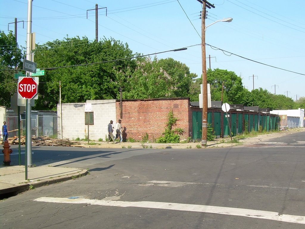
The location of this yuppie invasion is on the north edge of Druid Hill Park just east of Parkdale Avenue, near Woodberry. Below is a shot of Parkdale just inside the portion of the park beyond that which was spared from the bulldozer's wrath. The City has erected a seemingly permanent barbed wire gate to keep the entire public out. Everyone !!!!! That means you, whoever you are...


The City has kept the vast northern outback of Druid Hill Park almost totally off limits to all species of homo sapiens for many years. Signs say "No Trespassing" and various other admonishments. If that doesn't work, there are low gates. Beyond that are the barbed wire fences.

So obviously the function of the Druid Hill Park outback is not to serve human beings. So what is the function? Well, the City has cultivated various piles of debris and materials in various locations, so storage must be considered one of its prime functions. Druid Hill Park could be construed as a kind of urban backroom closet. Beyond that, there is the calming reassuring notion that since people are the source of most urban problems, as long as people are kept out of the park, there will be no problems.

Too bad the City can't solve its problems in other urban areas by just fumigating them of all human habitation. It's a very simple equation. No humans equals no problems. This is a very attractive selling point for the new yuppie houses that will be built along the edge of the Druid Hill Park outback. It's really a very time-tested, tried-and-true formula. Waterfront development works largely the same way. Nobody lives in the water. Ergo, no problems. Living on the edge of the water equates to problem-free living.


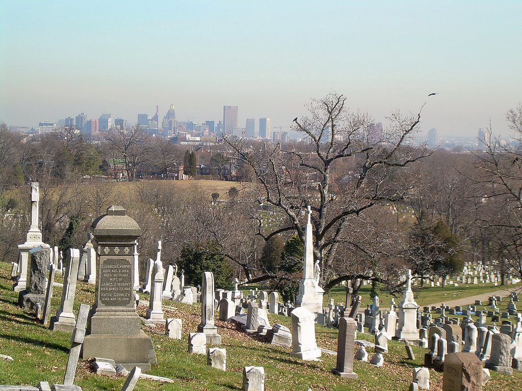
It has also worked brilliantly for many decades in an adjacent location on the edge of Druid Hill Park just to the east. The picture above shows Druid Hill Park looking westward from Hampden. Peaking through the trees on the hill are houses on Seneca and Parkden Avenues that are essentially nestled inside Druid Hill Park.


This idyllic residential setting on Seneca and Parkden sets the precedent for the housing that Streuver Brothers has planned for Druid Hill Park. Its a wonderful opportunity to create a new top quality residential community. Opportunities like this don't come along very often in Baltimore.

Druid Hill Park was not built to be the type of urban park that is a central focal point for its surrounding neighborhoods. In the nineteenth century, Druid Hill Park was originally at the very outer edge of the city. The southern part of the park was its front door, where people from the city would arrive at the end of the transit system. This was the "people" part of the park. Beyond it to the north wasn't really parkland at all, but just the rural countryside beyond the park.

Astonishingly in 2007, this is still the way Druid Hill Park functions. The northern outback of the park still isn't parkland. It's rural - even though it is now squarely in the city.

In the early 1960s, Druid Hill Park was shut off from the city even more by the construction of the Jones Falls Expressway. This reinforced the isolation of the east edge of the park. The Hampden neighborhood is directly adjacent to Druid Hill Park to the east, but they might as well be in different universes.


At any time in the past four decades, the wall between Hampden and the park could have been penetrated, but it hasn't. The photo above shows Druid Hill Park from Ash Street in Hampden. This indicates how simple it would be to create access to the park under one of the large expressway overpasses. The photo also shows the current construction of a sewage pumping station at this location. The park access could be incorporated into the pumping station project.

But instead, the lack of access to Baltimore's foremost park has always been a convenient stalemate situation. No humans equals no problems. But also no opportunities. It is as though people were and are afraid that any human intervention between people and the park would only cause problems.

But there are plenty of examples of artful park planning for human use. Central Park in New York is the most famous and obvious example. Central Park is used by millions of people. It is as thoroughly urban as any place can be, and yet it is still a park, and an extremely attractive, valuable and environmentally responsible one.

Beyond that, Seneca and Parkden Avenues are examples of people essentially living inside Druid Hill Park, and Baltimore has examples that go beyond even that. Fairmont is an absolutely gorgeous neighborhood in West Baltimore off Clifton Avenue that is almost totally surrounded by parkland. Dickeyville is a more well-known and celebrated historic neighborhood off Forest Park Avenue.

No one complains about these places, not even the tree huggers. Trees were lost to roads and houses when these neighborhoods were built, but many more trees remain and are planted anew, and these trees are truly cherished and nurtured. Those yuppies who buy the new houses that Streuver Brothers is getting ready to build will certainly do so as well. No one complains about a lack of trees on Seneca and Parkden.

We need to fully re-examine the relationships between the parks in Baltimore and the communities that surround them. We need to avoid thinking about parks as being simply a certain quantity of acreage, and start thinking of them as having the best possible relationship with the people who live around them and who will act as their stewards. Creating a full-time human relationship with a park is the best way to ensure that parks will no longer be used as a trash and storage receptacle.

There is much more potential for redesigning the northern outback of Druid Hill Park to foster a better relationship with human beings. There are some spectacular settings where the park and the people could interact.


Above is a picture taken from the hill above Seneca and Parkden Avenues, looking eastward toward Hampden. Further up at the top of the hill, the view is even better. This could be one of the best addresses in Baltimore, enhancing and enhanced by the park the surrounds it.

Another important strategy is the creation of defined edges for the park. This is a major problem for the north outback of Druid Hill Park, as it is for many other places in Baltimore (see Baltimore InnerSpace article on Carroll Park ).

The north outback of Druid Hill Park now serves mostly as the private wooded backyard for the people who live adjacent to it, as well as those who will buy the houses that are about to be built. This is fine for those people but not for the rest of us. Those who live near the park should be its stewards, but not its sole private beneficiaries.

The public should demand a public face for public park access, and this can best be done by the establishment of street edges that provide access and define precisely where the park begins.

Druid Hill Park could be synonymous with a truly prestigious address, to be shared between its residents and visitors. Who wouldn't want to visit a park that is both a pristine natural reserve and adjacent to the home of well-heeled residents who keep it that way? Of course, some fat-cats prefer to live in sealed-off gated communities, but many others would enjoy living where they can associate themselves with Baltimore's premier park. The north edge of Druid Hill Park should entice everyone.

SOUTHWEST PARK

THE SHINING CITY ON THE HILL ?

Stand in your front yard and look up in the sky. What do you see?

From several streets in Brooklyn Park, what you see in the sky are scores of trucks and trailers. No, it's not flying trucks, and it's not a heavenly apparition, although it's probably the closest thing we'll see to what R.E.M. referred to as "a truck stop instead of Saint Peter's" in their tribute to Andy Kaufman, "Man on the Moon".


The Brooklyn Park neighborhood west of Belle Grove Road is right next to the shore of the Patapsco River and Southwest Park, but nobody can see either of those landmarks from there, due to a sound wall constructed next to the Harbor Tunnel Thruway (seen at the end of the street in the photo above).

January 5, 2007

WEST BALTIMORE:
DEATH WITH HONOR AND GLORY

Please think of this as part of the time-honored Baltimore tradition of looking on the bright side of things, like naming our great NFL football team for the morbid-minded Edgar Allen Poe, or the way we take pride in our City's TV series like "Homicide".

December 31, 2006

Innerspace 2006

INNERSPACE IN REVIEW: 2006

Baltimore Innerspace is an alternative master plan that contains actual actions and projects, not bureaucratic gobbledygook. To review, here is your guide to what was covered in 2006.

TRANSIT

THE RED LINE - is the proposed east-west regional rail transit line that needs to be able to do two things:

- To integrate the regional transit system so that everything actually connects to everything else.

- To create places where a new kind of urban development can take place that actually depends on transit for its accessibility.

In these places, transit should be the dominant travel mode, not a nice "alternative" afterthought to the automobile upon which virtually all of Baltimore's economic growth has relied for the past half century. This requires a clean start, not a subtle retrofit.

EDISON-MONUMENT - is the East Side place where the regional transit system can become truly connected. This is a huge piece of vacant land adjacent to the Amtrak tracks where a comprehensive transit hub can be established for the integration of the entire bus and regional rail systems and MARC Commuter Rail. It is especially essential for East Baltimore and Downtown to have a link to the new super-regional economy, exemplified by the expansion of the military bases at Aberdeen and Fort Meade and the way that the entire Washington metropolitan area is being drawn closer to Baltimore. The Red Line plan for East Baltimore should be an extension of the existing Metro Green Line east of Hopkins Hospital along the Amtrak tracks. The MTA Red Line plans have totally ignored the need to integrate the transit lines in this way.

THE HAVEN STREET CORRIDOR - is the East Side place where the Red Line can allow transit to take its rightful place as the dominant transportation mode for new development. Ambitious development plans are already starting to come to fruition in CANTON CROSSING, BREWERS HILL and BAYVIEW. Ambitious Plans are also on drawing boards in HIGHLANDTOWN and GREEKTOWN. All of these plans need the Red Line to be built on a vacant freight siding adjacent to Haven Street in order to create the kind of transit-dominant environment that is necessary for transit line to have its maximum impact. This is in stark contrast to the "official" Red Line alternatives prepared by the MTA which try to subtly weave through the already established areas of FELLS POINT, CANTON and the BOSTON STREET CORRIDOR, where most development has already happened, travel patterns and habits are already in place, and the Red Line can have only a minimal impact.

THE FRANKLIN-MULBERRY CORRIDOR - is the West Side place where everything can get a fresh start. In most of Baltimore's old "highway war zones" like Fells Point, Canton and Otterbein, people have gotten on with their lives and adapted the vacant lots and structures to fulfill real needs. But people have been mostly just fussing, fretting and doing nothing about Franklin-Mulberry. That is hopefully changing, but you wouldn't know it by the look of what the MTA proposed for the Red Line. What is needed instead is a fresh concept - a downsized highway to reflect that it will never be I-70 but is still useful for funneling through traffic, and a fast efficient transit line which truly integrates with new development to make the most of the vast space available. The West MARC Station anchors the west end of this corridor and provides the multi-modal transit hub opportunities.

NEIGHBORHOODS


CANTON - is truly Baltimore's prototypical urban neighborhood of the 21st Century. That means using some basic tools to allow the aura of Canton to spread around Baltimore - mostly just simple things like four-way Stop Signs, angle parking and rooftop decks, set within the melange of formstone renovations and infill construction. Some people still think that Canton is all about expanding waterfront high rises and the resultant dense human activity, but they're wrong. There are opportunities in Baltimore for more of that, but not in a prototypical urban neighborhood like Canton.

SETON HILL - is one of those unique hidden hideaways where the people try to make a virtue out of their seclusion. Even their big magnificent park is obscured by walls. So seclusion appears to be only a small step from neglect.

THE GAY STREET CORRIDOR - is a forlorn place where the basic principles of traffic flow and traffic engineering have been thrown out along with a lot of other trappings of urban civilization, in what is sometimes referred to as the "Other Baltimore".

THE EUTAW STREET CORRIDOR - is Baltimore's closest resemblance to Le Champs Elysees. Well, it's not all that close, but compared with all the other streets urban designers want to call the Champs in their dreams, it's not bad. What Rue Eutaw needs is a roundabout at North Avenue to mend the division between RESERVOIR HILL and BOLTON HILL, and another roundabout at Dolphin Street to mend the division between Bolton Hill and UPTON and STATE CENTER. Roundabouts in these places also make sense from a traffic flow standpoint, making them attractive to sane smart motorists but not crazy ones.

RESERVOIR HILL - is separated from BOLTON HILL by big nasty North Avenue, which was widened many years ago in such a way as to eliminate the reasons why it might have needed to be widened in the first place, except to create a protective moat of destruction around Bolton Hill. Narrowing North Avenue could be part of a plan to mend the division between Bolton and Reservoir Hills, which along with a roundabout would refocus attention on this as a real place and not just a corridor.

NEW JONESTOWN - has a sort of traffic calming "thing" stuck in the middle of East Lombard Street at Albemarle, which only has the result of confusing traffic and pedestrians, creating an obstacle for both and taking away parking where it should naturally be. Median strips can be great people places, but only if they are designed very carefully. The new median nearby on South Broadway between Lombard and Fleet Street in UPPER FELLS POINT appears to fill the bill.

BROOKLYN - is absolutely the best neighborhood in Baltimore that has not been discovered by the trendies. There is an eerie resemblance to Federal Hill circa 1970 when you could buy a solid rowhouse hovering above the harbor for well under a $100k in pre-inflation dollars.

PENN STATION - is supposed to be a priority neighborhood for City government, but you'd never know by its rather scandalously abusive traffic patterns and street functions, including dumpsters in the middle of Oliver Street and totally uncontrolled expressway-bound traffic whizzing across the sidewalk on Charles Street. See the full Top Ten List of crimes against humanity. This isn't a neighborhood. It's a mess.

MOUNT VERNON - BELVIDERE - is the proposed integration of Mount Vernon, one of Baltimore's most famous neighborhoods, with one of the City's most obscure dead-end streets, Belvidere Street, which ties into our greatest and most celebrated cemetery, GREEN MOUNT. All of this is a logical, beneficial and realistic alternative to one of Baltimore's most spurious recurring pipe dreams, the conversion of the Jones Falls Expressway into a huge surface boulevard in order to attempt to integrate the east side prisons with the west side neighborhood.

PARKS


CARROLL PARK - is a great big beautiful park in Southwest Baltimore which is separated from the neighborhoods to the north by an industrial wasteland that virtually ensures that the park will not be an asset to them. The B&O Railroad Museum owns this wasteland, but they are preoccupied by strengthening their museum, not the land development business. What is needed is a whole new community fronting on Carroll Park's north edge in the grand tradition of the streets surrounding New York's Central Park and the more Baltimore-sized ambitions of the streets surrounding Patterson Park. Carroll Park North Edge would also be a fantastic place for a streetcar line to carry the historic B&O Railroad motif from the Inner Harbor to Montgomery Park, the city's largest office building.

FARRING BAYBROOK - is wonderful hidden park of wonderful hidden Brooklyn, with panoramic views spreading out all the way from Downtown to Dundalk.

OTHER UNKNOWN PLACES

THE LOST HIGHWAY - is an Interstate Highway so beautiful that it makes downtown appear in its background like the skyline of Emerald City looks from the poppy fields of the Land of Oz, while the poppy fields themselves make CHERRY HILL look like Roland Park. But there are no ramps to enable Baltimore-bound travelers to use the Lost Highway, so it will remain lost until we click our ruby heels together and build the proper ramps. It's something we could have done anytime, but we seem to be waiting until the Good Witch of South Baltimore tells us to.

SOUTHWEST PARK - is so incongruous that even the Land of Oz can't explain it. Located right off the PATAPSCO AVENUE light rail station is a vast green park on the shores of the Patapsco River that is overlooked by a mountain of tractor trailers. This would make a great place for parkfront transit oriented development.

That's the sign post up ahead... your next stop... Baltimore Innerspace.

December 5, 2006

Overlooking Carroll Park


One of Baltimore's most celebrated, most historic and most well-preserved mansions overlooks an industrial wasteland. The reason that this is tolerated is probably because the industrial wasteland serves as a buffer to separate the mansion and its vast glorious park environment from one of Baltimore's seediest neighborhoods. That situation feeds the all-too-common mentality that historic parks and treasures are things to be sealed-off from human riff-raff rather than treated as the human resources that they should be.


The mansion is Carroll mansion, home of one of Maryland's leading 18th century citizens. The park is Carroll Park, the west side equivalent of East Baltimore's Patterson Park, which has become the focus of neighborhood revitalization emanating in every direction. The neighborhood is Mount Clare, named after the birthplace of American railroading which now houses the B&O Railroad Museum. The industrial wasteland is mostly owned by the B&O Museum, which has hugely ambitious plans but has many less remote and higher priority places to spend its precious funds than here.


The Mount Clare neighborhood turns its back on the park. Its streets dead-end into the industrial wasteland where trash accumulates. Generally, the closer its houses are to the park, the worse they are maintained. The north end of the Mount Clare neighborhood abuts Union Square, which has been beautifully renovated along with the homes that surround it, while the properties right next to Carroll Park are mostly in a state of dissolution that makes it difficult to tell what is supposed to be residential and what is industrial.


The industrial wasteland is also occupied by rotting railroad cars that are the target of graffiti artists and other vandals and miscreants. These railroad cars also form a bit of an additional barrier between the neighborhood and the park. In the picture above, the neighborhood is hidden off to the left, while Carroll Park is hidden off to the right.


Carroll Park itself is beautifully maintained, considering that it has very little local constituency. Its shape is a huge trapezoid and only its smallest dimension, the three blocks on the east edge adjacent to Pigtown's Bayard Street, has a residential frontage (shown above). To the south is Washington Boulevard, which is mostly fronted by the distinctive historic headquarters of the City's streetcar fleet, now retrofitted for the storage and maintenance of MTA buses.


On the west edge of Carroll Park is possibly Baltimore's greatest recent preservation success story - the magnificent Montgomery Park, the City's very largest office building. While the magnitude of this success cannot be overstated, it underscores a planning principal that is well-known in urban areas throughout the country - that an office district that lacks support from other uses such as residential and retail will become a dead zone after the end of weekday business hours.

So it is the north side of Carroll Park, with the industrial wasteland that comes between it and the Mount Clare neighborhood, which is by far the longest dimension of park frontage. Hidden along a long appendage to the northwest corner of the park is the Carroll Park golf course, the vast Gwynns Falls Trail and the incredible Carrollton Railroad Viaduct, but these remote gems are hidden so completely from the rest of the park that they might as well be on the moon. Here is an urban neighborhood with its very own public golf course, probably the least elitist golf course in the whole metropolitan area, but it's still beyond most of the folks in Mount Clare.

Imagine if Patterson Park, or any other successful urban park anywhere, had to exist in the same type of environment as Carroll Park, particularly along its north edge. What if Patterson Park, instead of being surrounded as it is by rowhouses overlooking the greenery, had a vast intervening industrial wasteland like that which comes between Carroll Park and the Mount Clare neighborhood? What if instead of being drawn into the park by the surrounding streets, one had to cut through a totally undifferentiated thicket of weeds and bushes to get there?

Great parks are defined by the streets and communities that surround them. Imagine New York's Central Park without Fifth or Seventh Avenue (the latter better known as Central Park West) or Chicago's Grant Park without Michigan Avenue. All they would be is just big pieces of land. That's what Carroll Park is.

There is an irony to the way Carroll Park and Mount Clare evolved over the years. When the Carroll mansion was built in the 18th century, and even when the first railroad track was laid in the mid 19th century, they were on the rural fringe. This area has really never been urban. The inner city Mount Clare neighborhood went through its entire urban life cycle from birth to decay without an urban connection to Carroll Park.


The Carroll mansion's lack of an urban connection is reflected by the fact that the front yard of the house faces the back of the park. The mansion's elegant front gateway is shown above, only a couple hundred feet away from the Mount Clare urban wasteland in the background. The mansion is as disconnected from the City as its park surroundings.

What Carroll Park desperately needs is a front door that creates a community identity. The industrial wasteland along the north edge of Carroll Park should be replaced with an urban street that defines the edge of the park in the most public way possible, which would become the address of new rows of distinctive rowhouses that would overlook Carroll Park, the same way that Fifth Avenue overlooks Central Park. The worst address in Mount Clare would be instantly transformed into the best. The front yard of the Carroll mansion would be right across the street from the new houses, setting the architectural tone.


The entire Mount Clare neighborhood would then be redefined as the neighborhood that leads to Carroll Park instead of the neighborhood that backs up into an industrial wasteland. The B&O Railroad Museum would then finally be able to run its vintage train tours through the urban neighborhood that rightfully grew out of the rural hinterland that once existed, instead of through the land that time forgot.

The historic train tracks could also be adapted to run streetcars or light rail transit from the Inner Harbor to Montgomery Park, connecting downtown to the City's largest office building and encouraging further employment and residential growth, revitalizing the Mount Clare Junction Shopping Center and extending the reach of the tourist district to include the B&O Museum. This is a logical extension of the new urban wave which is currently proceeding from Camden Yards and Ridgely's Delight into Pigtown.

The Mount Clare neighborhood should overlook Carroll Park the same way that great urban neighborhoods overlook great urban parks throughout the world.

November 28, 2006

GAY STREET:
TRAFFIC LAWS VERSUS THE LAWS OF THE STREET

The deterioration of Gay Street between North Avenue and Preston Street is a sad urban tale that has been told many times, not just there but in Baltimore as a whole and indeed throughout America, with many lessons learned and not learned. But the story has seldom been told through traffic regulations. Even so, the lessons may be familiar.

No one could argue with the fact that the City has large swaths of real estate that are simply urban failures. While it is the boarded up housing and vacant lots that are the most apparent manifestations, illogical traffic and parking regulations are also part of the scene.

Gay Street between North Avenue and Preston Street is one of the clearest examples of such failure. And while the boarded up housing and vacant lots may be the result of some complex pathological urban process, the traffic regulations are simply the result of blatant neglect and incompetence.


This is Gay Street looking southward from North Avenue. There are three lanes, curb to curb, next to the very narrow sidewalks which are next to mostly blighted housing and vacant lots. Parking is never allowed on the northbound curb, where the bus is in the picture above. Parking is allowed except between 7 to 9 AM and 4 to 6 PM on the southbound curb. The center lane is designated for reversible traffic flow. The southbound sign says, "Curb Lane Only 4 PM to 6 PM", which means that the southbound traffic must use only the curb lane between 4 and 6PM, because the center lane is given over to the northbound traffic (leaving downtown) during the evening peak period.

The most obvious problem created by the parking regulations is having fast-moving through traffic and buses mere feet away from the houses, 24 hours a day. How could a residential community possibly endure under such conditions? The answer is that it cannot and has not.

But there is an even larger traffic problem. Until 4 PM each day, parking is legal along the southbound curb. Then at exactly 4 PM, parking on the southbound curb becomes illegal and at exactly that same moment, the southbound curb lane becomes the only lane available for southbound traffic. At 3:59 and 59 seconds, the center lane is designated for southbound traffic and exactly one second later, that lane becomes designated for northbound traffic.

Furthermore, there are no electronic signals to choreograph this split-second transition from southbound to northbound traffic in the center lane, or from parking to no parking along the southbound curb. There is nothing to synchronize the watches of the motorists making this transition, or to inform the motorists who have no watches or are not looking at their watches.

In other places with reversible lanes (the Bay Bridge for example), there is a time period when the reversible lanes are not used in either direction. The reversible lanes are swept clean of traffic so that a transition can be achieved for use by traffic in the opposite direction. This is not done on Gay Street because at the split second before the transition occurs, it is totally legal for a car to be parked in what becomes the only southbound traffic lane one second later. There is no time to ticket or to tow these cars, which in the Baltimore City government are two separate time-consuming processes.

But what the signs say is not what actually occurs on Gay Street. What actually occurs daily in the center lane of Gay Street is a good analogy for life in general in this forlorn neighborhood.

First of all, the public laws are rendered meaningless. It is a common occurrence to see traffic traveling in both directions in the center lane simultaneously. One driver or the other has the legal right to be there based on who is adhering most accurately to the clock. Of course, what it really amounts to is a case of the drivers staring each other down and one of them baling out. It may be the one who is in the right, or it may be the one who is in the wrong, or it may be the one who is least strong-willed (i.e. has the least balls) or it may be the one who is more able to pull to the right and manage to avoid the traffic or parkers in that lane.

Secondly, the true law that governs local behavior is the law of the street. Sane drivers avoid the center lane. Of course, if the curb lane is blocked, legally or otherwise, one cannot avoid the center lane. So the most sane drivers avoid Gay Street altogether, which is the chief reason why Gay carries less traffic here than north of North Avenue where it is called Belair Road. Slightly less sane people will drive on Gay Street but try to avoid the center lane. Still farther down on the sanity scale will be the drivers who seek out the center lane and "dare" opposing drivers to do likewise. Still further down the sanity scale will be those who dare to park their cars on Gay Street near the 4 PM bewitching hour. Finally, there are the most crazed and desperate - those who live on Gay Street. There are not very many of those people anymore.

It is not difficult to image how the "law of the street" regarding traffic regulations might fit into the local etiquette regarding other endeavors of neighborhood commerce and social life. It takes a lot of nerve to survive on Gay Street.

But what is truly astonishing is that the posted traffic regulations on Gay Street are the exact same as they have been for decades. Once upon a time, Gay Street was a nice neighborhood. It was certainly a much nicer neighborhood when the current traffic and parking regulations were put into effect (the 1960s? the 1970s?) than they are now.

This illustrates the slow quiet cancerous effect of bad traffic and parking regulations and urban problems in general. Not many people are going to just get up and leave town when the City puts some up some traffic sign in front of their house that they don't like. You may not even have a car so you may not even give it much thought. Many City people didn't own cars back then and many still don't. The City's attitude has always been to deal with parking problems where there are a lot of parkers. After all, the squeaky wheel gets the oil.

The biggest event on Gay Street in recent history was the riot of 1968. That was south of this area, and that portion of Gay Street was then closed completely and turned into a pedestrian mall. That has generally been regarded as a failure too, but it is interesting that it was exactly the opposite kind of failure that Gay Street has experienced between North Avenue and Preston Street. It was a failure of no traffic, as opposed to a failure of traffic. At least it was not a failure of neglect.

The larger lesson is this: An urban neighborhood must be nurtured as a neighborhood, not as traffic moving on a street to be manipulated by signs and regulations that are far less powerful than the innate laws of urban survival, growth, life or death.

November 17, 2006

NEW JONESTOWN:
NOT ABOUT A ROUNDABOUT

The City has given us another example of how NOT to design a roundabout, or maybe a non-roundabout. Who knows what they were thinking when they designed the thing at East Lombard and Albemarle Streets in the New Jonestown housing development?

Previously, we discussed the failed roundabout at Wilkens and Mount Street, but at least that was a real roundabout. This one is basically just a traffic obstacle, and not a very good one.


Lombard is a two lane one-way westbound street when it approaches the non-roundabout. One lane is striped to go to the left of the obstacle and one lane to the right. As you can see from the picture above, the orange barrel that denotes the place where traffic is not supposed to go (straight ahead) has been knocked over by someone who indeed drove straight ahead. The barrel replaced a sign that was previously supposed to inform drivers not to drive straight ahead, but which was also knocked over by someone who drove straight ahead.

Things are actually even more confusing beyond the non-roundabout where the street comes back together. The lane to the left of the roundabout re-emerges beyond Albemarle as a lane where parking is allowed at night. There is nothing, not even a barrel, to inform drivers that the one and only lane between the curbs to the left of the non-roundabout becomes a parking lane. Either the driver will crash into the parked car that occupies its lane, or try to swerve to the right into the lane that may be occupied by a driver swerving from the right and who legally has the right-of-way.

In sum, the one left lane often becomes zero, while the one right lane becomes two. This is really stupid.

So what was the reasoning behind this non-roundabout? It looks like an extremely lame attempt to create a Savannah-style neighborhood park to add interest to the setting of the new houses. EXTREEEEEMELY LAME, I'd say. You'll notice from the photograph above that there are no benches or street furniture in the space. There are no trees. There is no art or sculpture. There is nothing except an orange barrel, that replaced a sign, both of which have been knocked over.

But it's even worse than that. You'll notice from the photograph that there is absolutely no parking allowed in the block that contains the non-roundabout, even though the total width in this block is about twice what it is in the blocks before and after, both of which allow parking at least during off-peak hours.

This is a major deficiency throughout the New Jonestown neighborhood. There are many block faces where parking is not allowed. On-street parking is a very important element of urban neighborhoods in places like Baltimore. No matter how good a house's rear access might be, there are times when you might want to park in the front to bring something in the front door.

Moreover, streets without on-street parking have a desolate quality which allows the through traffic to dominate. A comparison to adjacent Little Italy is revealing. Much more on-street parking could have been provided in New Jonestown with just a bit more attention to traffic patterns and curb locations. Without parking, nothing stands between moving traffic and pedestrians. Except maybe an orange barrel.


Then again, sometimes the City actually does things right. Above is the new median strip that was recently completed in South Broadway between Baltimore and Fleet Streets in Fells Point. It replaces a meager four foot wide concrete strip. Broadway still has four lanes - two in each direction - and approximately the same number of parking spaces. But previously, the parking spaces were head-in at an angle, so the entire street looked like a big parking lot. Now it looks like a street in the best sense - not just a place for cars, but also for people. The amount of pavement has been reduced, while the functionality has increased as four rows of parallel parking has replaced two rows of angle parking.

Some might argue that there is too much loitering on Broadway. But even loiterers try to find the best place to do their thing, so what are you going to do? Make a place unattractive just so loiterers will stay away? That defeatist attitude is just what is often used to design places, to strive for mediocrity.

Instead, we should strive for high-quality loitering. Loitering should be very public. It should not be allowed to slip into semi-private recesses where it appears mysterious and potentially threatening. In the public realm, activity should be public, while private places should be clearly private.

There should be no room for ambiguity. Questionable police actions and arrests are the result of such ambiguity. A public space that is obviously public helps make human actions explicit, especially among loiterers. Ambiguity is thereby eliminated, and both the police and the citizens will know where we stand.

The most public urban places are in the middle of median strips, clearly separate from anyone's private property or space. The City needs to have median strips that are hospitable, attractive and well-designed. Benches, trees, landscaping, and on-street parking can all be used to contribute to this.

These lessons can be applied all over Baltimore, most notably to Pratt Street in the Inner Harbor, where loitering is now allowed to hide and fester behind large earth berms. This portion of Pratt Street would be an ideal place for a highly visible median strip that separates through traffic from the service drive for Harborplace, the World Trade Center and the Aquarium. This median could efficiently and unambiguously serve a bikeway, a transitway, and yes, loiterers. It could be done even better on Pratt than many other streets because this section of Pratt has no cross traffic.

South Broadway is an outstanding example of how this can be done right. West Lombard at Albemarle is an outstanding example of how this can be done wrong.

October 29, 2006


THE RED LINE SHOULD TURN GREEN


Running Red Line rail transit through the streets of Fells Point would repeat the same mistakes that were made when the Central Light Rail line was rammed down Howard Street, only worse. Light rail has done little to help Howard Street. It has overwhelmed the small-scaled streetscape to accommodate the block-long 300 foot trains and has eradicated vital on-street parking in the process.

Regional rail transit is effective only when it is fast and fits in. On Howard Street, light rail is painfully slow and could be even slower on the narrower Fells Point streets, where unlike on Howard, it would have to share its lanes with traffic.

Instead of running the Red Line on the streets of Fells Point, regional rail in East Baltimore should be built as an extension of the existing Metro Green Line, east of the current Hopkins Hospital Station. This can be built in a corridor in which rail transit can be established properly from the "ground up" rather than as a weak retrofit, where it can truly serve regional travel needs, and where a brand new culture of transit oriented development can be created.

As illustrated on the diagram above, six potential station locations along a three mile East Green Line Extension have been identified where regional rail transit can become a true foundation for the future.


The above photo shows light rail on Howard Street looking north from Madison in the Antique Row district. This illustrates how NOT to provide regional rail transit. From the neighborhood perspective, the biggest and most obvious problem is that parking has been totally banned from the west side of the street (to the left). Merchants in areas like Antique Row and Fells Point rely heavily on street parking for their customers.

Another problem here is that the closest light rail station is two blocks away. Regional rail can only perform properly if stations stops are spaced at least a few blocks apart, and activity will not be attracted to transit if it is not oriented to these stations. Moreover, on Howard Street, much of the parking has been wiped out on all blocks, but in Fells Point, the blocks with stations would be the ones that have their parking eliminated.

On Howard Street, the light rail runs painfully slow. But in Fells Point, it would be even slower, because the streets are narrower and there would be no way to keep the very heavy traffic off of the tracks, and since three car trains would take up an entire block, there would be no place else for the traffic to go.

Light rail is supposed to evoke fond memories of streetcars, but that is where the similarity ends. It is streetcars rather than light rail that would be at home on the streets of Fells Point. Unlike light rail, streetcars require stations that are only slightly longer than bus stops, so the lost parking would be negligible, even if stops were more frequent. Light rail is also intended to serve longer trips, such as Hunt Valley to the airport or Social Security to Canton, so travel speed is of the utmost importance. That is why light rail is out of place on slow downtown streets, whether in Antique Row or Fells Point.

Light Rail transit is supposed to transform the places it goes through, but on Howard Street or Fells Point, the transformation can only be for the worse.


The photo above shows the corridor where regional transit should be located in East Baltimore: As an extension of the existing Green Line Metro along existing rail rights-of-way for Amtrak just north of Eager Street and an unused Conrail branch just east of Haven Street.

Unlike the Red Line culture clash in Fells Point, fresh opportunities would be created at station areas along an east Green Line. They include the following:


BIOTECH PARK - This photo, looking east along Eager Street from Washington Street to Broadway, shows what a radical change is now taking place just north and east of Hopkins Hospital, where many blocks of new houses and employment centers are about to be built. The Metro subway currently ends right under the portion of Broadway shown in the background here. Now is the time to plan for a Metro extension that would proceed under this section of Eager Street and rise to the surface in the Amtrak corridor just a block to the east. A station could be incorporated into the portal where the Green Line would emerge from underground, thus making it much easier to build, secure, and assimilate into the community.


BEREA/MADISON PARK - Further east along Eager Street, the Amtrak corridor is lined with marginal and abandoned buildings and vacant lots that are ripe for redevelopment as central elements in the effort to expand the redevelopment momentum created by the Biotech Park. The City has already begun efforts to acquire property for redevelopment, both here and to the north near the American Brewery.


This view provides an overview looking west from Edison Highway toward the Hopkins Hospital skyline. The Amtrak tracks are under the power poles on the right. The Metro extension would be just left of the Amtrak tracks under the large trees.


EDISON/MONUMENT - This huge tract adjacent to the Amtrak tracks would be a perfect location for a comprehensive transportation hub, serving both a Metro Station and a MARC Commuter Rail Station, as well as bus transfers and parking. This will facilitate easy connections between thousands of daily bus and rail trips between Cecil, Harford and Baltimore Counties, Downtown Baltimore, and all the way to Washington D.C. It would thus be a vital link to the State's strategy for accommodating the thousands of new federal and spin-off jobs for the expansion at Aberdeen, Fort Meade and in the DC metropolitan area. This is crucial to creating a true REGIONAL transit system and diverting traffic overload from I-95 as well as the surface streets of East Baltimore.

Additional development to support the transit line and/or maintenance facilities may also be provided, including a replacement facility to allow redevelopment of the MTA bus yard on Oldham Street, which is the critical link between Greektown and Bayview for the continued expansion of housing and health-related jobs.


The Southeast Metro Extension would diverge from the Amtrak right of way at Haven and Monument Streets, and then proceed southward along an unused rail spur owned by Norfolk Southern which begins at the two bridges shown here over Haven (to the left) and over Monument Street (to the right.) Amtrak is on separate tracks just behind these two bridges. A spur eastward to Bayview and beyond could be easily built from this point.


HIGHLANDTOWN/GREEKTOWN - The Green Line extension would swing southward from the Amtrak corridor on an unused rail branch just east of Haven Street. The station location shown here is at Eastern Avenue in Downtown Highlandtown, which is the past and future central hub of southeast Baltimore (NOT along the waterfront where development is virtually all done). The huge vacant Crown Building is shown in the background, and represents the vast redevelopment potential of this area, extending into Greektown and Bayview to the east.


BREWERS HILL - Streuver Brothers is already doing much to redevelop this area, including the Natty Boh Building and vicinity, but that is just the tip of the iceberg. The transit line would occupy the green swath to the right of the photo above taken just south of O'Donnell Street, surrounded on both sides by new development opportunities.


CANTON CROSSING - The transit line would terminate at the Ed Hale waterfront complex, near the intersection of Boston and Conkling Streets. The high rise First Mariner Bank Building shown is just the first phase in creating a new urban center to extend development beyond the waterfront toward the east.