December 31, 2009

Decade in Review

MARYLAND'S DECADE IN TRANSPORTATION:
SAME AS IT EVER WAS
The most recent installment of Michael Dresser's column in the Sun was an excellent summation of the top ten transportation stories of the past decade. But what really struck me is how little has changed in the past decade. Sure, we couldn't have expected to be driving around in flying cars like The Jetsons by now, but why are we stuck in neutral?

Michael Dresser's list could have been written prior to the '00s instead of after it was over. The names would have been slightly different, but the ten stories could have been just the same.

So now, as another decade turns, let's party like it's 1999 and see how the descriptions on Michael Dresser's own list (presented in his same order) might have read if it had been written before this decade rather than after:

10 - Light rail double tracking - Governor Schaefer had to fire MTA Administrator Ron Hartman for the wildly underestimated cost of the central light rail line and the ensuing cover-up. After about fifty percent worth of cost overruns and ridership underruns later, the line was finally completed in 2006, as it had been originally conceived in the 1980s. Some of the second track had been deleted from the project that opened in 1992 - a deja vu for the single track Red Line tunnel currently planned by the MTA under Cooks Lane.

9 - Continuing deadly carnage on the highways - Will this ever change?

8 - Transportation funding crisis - Gas tax stuck at 23.5 cents per gallon. Read Governors Glendening, Ehrlich and O'Malley's lips: No new gas taxes. The good thing about a lack of funding is that it requires intelligent planning instead of throwing money at the problems. The bad thing is that when real money is not available, planners prefer to throw play money instead.

7 - Inner Harbor water taxi done on the cheap - It's a tiny body of water with big body currents, which is its unique charm. Baltimore is not Venice or San Francisco or anywhere else. Respect it or face deadly consequences.

6 - Ouster of MTA Administrator - Wheels fall off buses, metaphorically and literally. Baltimore transit system ridiculed far and wide. See #10.

5 - Baltimore and Washington compete for the same transit money - Washington cleans Baltimore's clock because they take transit seriously. Planning for Baltimore's Red Line began at the turn of the 2000s and a decade later we still don't have a feasible fundable or workable project.

4 - Bay bridge needs major repairs - What else is new?

3 - Planning to replace Woodrow Wilson Bridge begins in earnest - We should have savored this one. It was most likely the last time a billion dollar project will ever be done in Maryland without tolls. And nowadays, it seems that every project costs in the billions.

2 - Proposed InterCounty Connector emerges as statewide political issue - Governor Glendening tries his best to kill the highway, but it refuses to die. Future Gubernatorial wannabes line up to save it, most notably his handpicked successor Kathleen Kennedy Townsend.

1 - Baltimore has a dangerous undersized freight rail tunnel under Howard Street - Fixing our entire rail system, not only freight but passenger transit at the local, regional and even interregional magnetic levitation or other future high speed technology, depends crucially on what we do about this obsolete downtown tunnel and the trains that now use it. So ten years later, we have done nothing, and planned almost as little.

Gee, writing this 1999 list was so easy, I might as well write the list for 2019 while I'm at it.

To be continued...

October 9, 2009

MLK-FMX

A DIRECT SOLUTION TO THE FRANKLIN-MULBERRY STALEMATE DISASTER
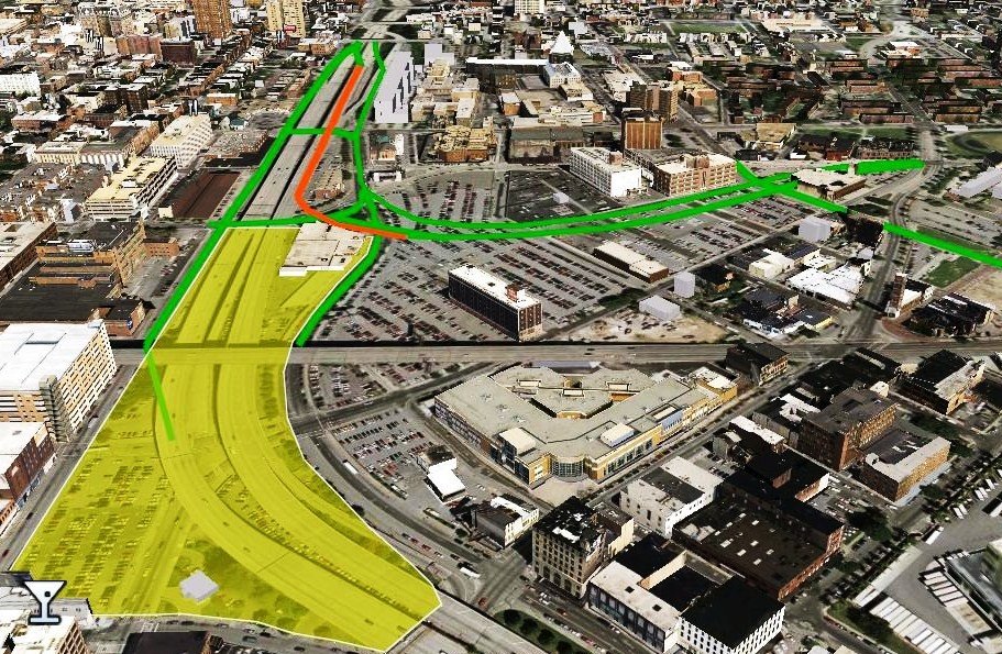
The solution: Consolidating all the traffic into the current eastbound roadway to the right, thus freeing the remaining land now occupied by the median strip and the westbound roadway (left) for new transit-oriented development linked to the community.

Nobody denies that the US 40 "Highway to Nowhere" was instrumental in destroying the Franklin-Mulberry community in West Baltimore in the 1970s. But the truly amazing thing is that, three decades later, the City insists on maintaining that highway as-is, even in its so-far futile attempt to rebuild the community around it. That hasn't worked over the past thirty years and it won't work in the next thirty. And rail transit alone can't fix it either, as every other Baltimore area community with rail transit can attest, from Howard Street to Hunt Valley and Owings Mills.

The City is still in a state of denial about the cancerous effect created by this highway. Along with the MTA, they only see the wasteland it created as a vacuum which the transit Red Line can fill (with more parking for MARC commuters). They still cling to the expensive 1970s plan to cover over the highway "ditch" rather than truly repair it, which has been demonstrated to be unworkable by the decades of inaction.

September 1, 2009

MTA vs LHF Plans


MTA "PREFERRED" RED LINE ALTERNATIVE 4C 
VS. THE "LOW HANGING FRUIT" PLAN

The MTA Red Line philosophy is "one size fits all". And if the shoe doesn't fit, the MTA will spend hundreds of millions of dollars extra to bury as much of the line as they think they might afford so no one has to look at it. If the crammed-in lines don't connect, they'll build yet another tunnel to make people walk between them. Then they'll cram the rest of the line through the communities that they can't afford to bury, whether anyone likes it or not.

The "Low Hanging Fruit" philosophy is a total opposite: Build a rail transit system that fits its environment, so that people will orient their lives to it. Take advantage of the opportunities that have already been planned to make the city more livable, and bring those plans into harmony with the rail transit system. Build transit to transform the city, not to cram it through.

August 21, 2009

Low Hanging Fruit Plan

THE BEST, SIMPLEST AND MOST EFFICIENT RAIL TRANSIT PLAN - TO REPLACE THE MTA'S CONTRIVED CONTORTED "PREFERRED" PLAN

For years, the MTA and their cohorts have been accusing their opponents of trying to disrupt the Red Line process. What we're really doing is trying to make the process work.

After numerous delays of their own, the only way the MTA was able to come up with something that looked even superficially feasible was to inflate the ridership numbers at the last minute, after submitting lower numbers to the Federal Transit Administration in their Alternatives Analysis and Draft Environmental Impact Statement. While inflating the ridership numbers by increasing future population and employment projections, the MTA got rid of two stations and narrowed the tunnel under Cooks Lane to a single reversible track, in their last ditch effort to make the cost and benefit numbers work.

Thus, the MTA's "preferred" Red Line alternative was something that no one preferred during the process, based on data that was unavailable. Nor would anyone ever want to "prefer" their plan.

July 22, 2009

Hilton Terminal

Hilton Terminal: The only solution to the west end Red Line mess

Nobody else has a solution, so I'll just have to do it. This plan original appeared in March in Baltimore Brew.
Now the MTA has said they need to save money by building only a single track tunnel under Cooks Lane. Obviously, if the MTA can't build a decent tunnel under Cooks Lane, that means they really can't build a tunnel under Edmondson Avenue either, which has become a non-negotiable demand of the surrounding community. But if the MTA ignores this demand, they will probably end up in court and the Red Line will die a slow death.
So in the spirit of reconciliation, I offer this plan. (I don't know why people think of me as a troublemaker. I only want to help.)

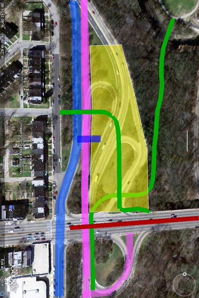
The Red Line should end at Hilton Parkway, where it will still serve the Edmondson communities, but it will not ram its way into them. Then build a terminal station/parking garage/Leakin Park Gateway where part of the obsolete Hilton Parkway interchange now stands on land that once belonged to the park.

I've sketched the rough concept in the Google Earth image above. The colors are:
RED - The Red Line - ending in a widened median of Edmondson Avenue at Hilton Parkway.

YELLOW - A multi-level structure built on what is now the north half of the Hilton Parkway interchange. The top level would be new parkland with a playground, commercial kiosks serving transit riders, and a gateway entrance to the rest of the park. The lower levels would be parking.

This photo shows the grade differential between Hilton Street (above) and Hilton Parkway (below) which enables the construction of an almost invisible parking garage in the hole created by the interchange. The houses in the background would then look out on parkland instead of a highway interchange.

MAGENTA - Hilton Parkway, straightened out and narrowed into the westernmost underpass under Edmondson Avenue. The ramps south of Edmondson would be unchannelized to accommodate traffic now using the ramps to the north.

BLUE - The existing southbound ramp from Hilton Parkway to Edmondson Avenue, which would be adapted to carry two-way traffic including some vehicles now using the ramps. It may be necessary to feed all southbound traffic from the north into this road to nullify the potential conflicts at the north end. A short bridge over the parkway below would provide access to the parking garage.
GREEN - New pedestrian and bike paths through the new parkland on top of the parking deck, leading to the Gwynns Falls Greenway shown in the upper right corner, at the Leon Day Park playfields off of Franklintown Road. Connections to this path would be provided over the top of Hilton from Harlem Avenue (shown, upper left) or Denison Street, as well as inside the existing underpass under Edmondson now used by northbound Hilton Parkway traffic.
Here is the Hilton Parkway underpass seen from the south, with Edmondson Avenue on top. Traffic would be consolidated into the road going through the left tunnel, and the right side would be renovated for pedestrians and bikes. If Edmondson Avenue can be widened sufficiently, a stairway up to the transit station in the Edmondson median could be provided.
This photo shows the gorgeous Gwynns Falls Valley which is now all but invisible and inaccessible to the community because of the interchange. The new pathway from Hilton/Edmondson to the Greenway Trail would be just to the left of this photo and the railroad tracks.

Implementing this plan would enable the Red Line to work with the community instead of tearing it apart. It would also save a ton of money compared with what the MTA wants to do (a squeezed force-fed unworkable Red Line), and two tons of money compared to what the community wants to do (an underground Red Line).

July 7, 2009

Something Borrowed, Something Red

A RED LINE PLAN TO HARBOR POINT -

AND A DIRECT ROUTE TO COMPRHENSIVE RAIL TRANSIT TO EVERYWHERE

Revised diagram showing Fayette Street Red Line thru Downtown to Harbor Point, Orange Line to Jones Falls Valley and Yellow Streetcar System

Here's a Red Line plan that unlike the MTA preferred plans, would be rather easy and cheap to build, would provide tons of flexibility, would be very politically popular, and doesn't propose anything stupid.

Better yet, the MTA has already done most of the basic alignment planning on most of it, so they wouldn't be able to give their usual knee-jerk response about Red Line plans being outside their scope. In fact, most of this plan is assembled from other people's plans, not mine (with just a couple of exceptions where I don't know of any other plans.)

The best part is probably that this is a great way to create a comprehensive rail transit system relatively quickly, probably at no more cost than the piecemeal partial plan the MTA wants to do.

So without further ado, here is the full phased system, starting with:

1 - RED LINE LIGHT RAIL UNDER FAYETTE STREET

The Red Line would be built as light rail in a short tunnel under Fayette Street, where it would have a reasonably easy pedestrian linkage with the existing Charles Center Metro Station just to the south. It would emerge out of the ground just east of this point near Gay Street, adjacent to City Hall. It would stay on the surface of Fayette Street eastward to Central Avenue, then proceed southward on Central Avenue to the waterfront at Harbor East, where it would enter the vast undeveloped Harbor Point property (formerly Allied Chemical). The final termination point would be near the intersection of Caroline and Thames Street at the west end of Fells Point.

The Red Line would thus hit all the right spots - the Charles Center Metro Station, Harbor East, Harbor Point and Fells Point. It would also miss Canton, much to the relief of the active opposition there. Unlike the MTA's alternatives, it would provide great service to the heart of Harbor Point, jump-starting future development there and hopefully giving it an equity boost. It would also cost a whole lot less than the City and business community's preferred Red Line tunnel alternative, which includes its long scary pedestrian tunnel under Light Street.


Red Line on Central Avenue thru Harbor East, terminating at Caroline and Thames Street in Harbor Point development site. Fells Point is to the right (east), Inner Harbor to the left (west). Yellow Line would be streetcars on Fleet Street and Eastern Avenue couplet.

From Central Avenue westward, this alternative is identical to one the MTA has already mapped out. It is also very similar to what was originally defined as the "high priority" route segment in their system 2002 plan, before the extension to Bayview was added two years ago. The big difference is that it would serve the heart of the Harbor Point development. And none of this plan weaves any tight threads along any narrow streets.

2 - YELLOW LINE STREETCAR

This would essentially be the streetcar plan developed by the Charles Street Development Corporation, between Charles Village and the Inner Harbor. This plan has already undergone a rather rigorous professional feasibility study. Hopefully, the powers-that-be would choose to re-evaluate this plan in the context of its role as part of a full rail transit system, but it stands fairly well as-is. However, this streetcar line should not be a mere "circulator". It should be the backbone of a comprehensive local transit system serving the new enlarged multi-use downtown that we have heard so much about lately (or not so lately, if you've been paying attention.)

3 - GREEN LINE METRO EXTENSION BEYOND HOPKINS HOSPITAL

This is already supposed to be a "high priority" MTA project anyway. The Metro absolutely needs to be extended somewhere beyond Hopkins Hospital.


The standard MTA practice for alleged high priority projects that lose favor is to just let them sift to the bottom of the workpile where it is hoped that they will eventually be forgotten (see MagLev, Downtown Light Rail Loop, Inner City Shuttle Bugs, Downtown Glen Burnie/Marley Light Rail Extension, etc.). But it should not be forgotten that the existing Hopkins Hospital Metro station was built with no facilities at all for feeding the transit system, so it is totally inappropriate as a regional rail terminus. It also needs to connect to an East Baltimore MARC Station, for which the existing Metro is far better suited as a feeder to downtown than is the Red Line from a MARC Station in Bayview.

(Of course, the MTA thinks my idea of extending the Metro eastward along the Amtrak tracks toward Bayview, rather than northward under Broadway, is dumb. If that is what the MTA believes with all the intellectual fortitude at their disposal, I'm powerless to change them. Just extend the Metro somewhere.)

4 - STREETCAR LINE EXTENSIONS

Now is the time to giving serious thought to what an eventual comprehensive streetcar system should look like. The following are mere suggestions. I apologize that they happen to be my own suggestions, and not someone else's. Please replace them with your own if you wish.

(a) Eastward along Pratt Street in the Inner Harbor to Pier 5 to the Red Line corridor to Fells Point, Canton, Brewers Hill, Highlandtown and/or Bayview.

(b) Southward to Port Covington and/or the Key Highway corridor.

(c) Northward to Northwood and Morgan State University.

(d) Westward to Mount Clare, Carroll Park and Montgomery Park.

(e) Somewhere else.

5 - JONES FALLS LIGHT RAIL ORANGE LINE CONNECTOR

This has been proposed by Edison Properties as part of their proposal to knock down the lower Jones Falls Expressway to create attractive new development sites.

Running the Red Line under Fayette Street, then bringing it up to the surface near the JFX, would greatly enhance the Edison Properties transit plan. Shifting the expressway southeast of the prisons to divert traffic away from this area would enhance their transit plan still more.

This would allow the existing North Central light rail Blue Line from Hunt Valley to have a faster and better route into the heart of downtown and to the Charles Center Red Line station, facilitating transfers to the rest of the system. It would also include a direct link to Penn Station.

(Note: A previously shown light rail connection branch southwest of the Red Line from MLK Boulevard/Fayette Street to Mount Clare and Carroll Park would not be feasible under this plan, and would need to be streetcars instead, as shown on Yellow Lines.)

POSSIBLE OPERATING PLANS

Under this system, all of the following operating scenarios are possible. Major intermediate transfer stations are noted:

- Green Line Metro: Owings Mills to Lexington Market to Charles Center to Shot Tower to East MARC Station

- Blue Line Light Rail: Hunt Valley to Lexington Market to Camden Yards to BWI-M Airport or to Cromwell / Glen Burnie

- Red Line Light Rail: Social Security to West MARC Station to Lexington Market to Charles Center to Harbor East to Harbor Point/Fells Point

- Yellow Line Streetcar: Charles Village to Penn Station to Charles Center to Inner Harbor to Port Covington or to Harbor East to Canton/Highlandtown

- Orange Line Light Rail: Hunt Valley to Penn Station to Shot Tower to Charles Center to Lexington Market to West MARC to Social Security (Note: Orange Line connection previously shown to Carroll Park / Montgomery Park would not be feasible, and should be streetcars instead.)

- Purple Light Rail Line: BWI-M Airport to Camden Yards to Lexington Market to Penn Station to Shot Tower to Charles Center to Lexington Market to West MARC Station to Social Security (or some of the above).

And the best part is: Almost all of these were the ideas of the MTA, Charles Street Development Corporation and Edison Properties. Almost none of this plan was originally mine.

June 10, 2009

Jones Falls Expressway


HOW TO REINVENT THE JFX:
BEND BUT DON'T BREAK IT

The key is to wrap it around the prison district, to distribute its traffic onto all the streets it should go to, and to allow the streets south of the prisons toward the waterfront to have a civilized environment, carrying only the traffic that wants to go there. Green is surface streets and highways. Red is elevated - southbound only. Yellow is new developable property.

Read the whole story at BaltimoreBrew.com

May 31, 2009

Collington Avenue

COLLINGTON SHOOTING BEGS THE QUESTION:
HOW IMPORTANT IS URBAN GEOGRAPHY?

A small "Crime Brief" in last Thursday's Sun describes a typical senseless shooting on the streets of Baltimore: "Butchers Hill man fatally shot near home Wednesday". Except technically, the man did not live, nor was he shot, in Butchers Hill. But I live in Butchers Hill so the story really stuck out for me.

Real estate agents often exaggerate boundaries of more popular neighborhoods to catch people's attention, so it seems plausible that a newspaper might do that too. Several of my neighbors caught the error and notified the Sun, which soon corrected the online version of the story, although this time they omitted the neighborhood from the headline. Seems that Middle East doesn't sell as well as Butchers Hill.

So what's in a neighborhood boundary? If it's the waterfront, the answer is fairly obvious, but any urban street can be imbued with perceptions that can change property values, racial composition and feelings of safety that become no less real. The street of the shooting, North Collington Avenue, is a classic case in point.


May 15, 2009

Morgan to Canton Streetcar Line


MORGAN TO CANTON STREETCAR LINE

Here's an idea that should expand your visioning horizons, and provide an escape route from the MTA's Green Line planning stalemate.

The MTA actually claims to be considering streetcars as a transit mode for the Green Line project from Hopkins Hospital to Morgan State University. This demonstrates that the MTA is ignoring the central overarching issue, which is what they should do with the heavy rail Metro which currently terminates suddenly and inappropriately at Hopkins Hospital. All it indicates is that the MTA is simply doing cookbook transit planning, and streetcars happen to be the fashionable mode du jour these days.

May 14, 2009

BaltiMorphosis


Introducing BaltiMorphosis.com

Bravo, Peter Tocco. He's taken my abstract concept for fixing the Franklin-Mulberry corridor and brought it to 3D graphical model life in his new website, BaltiMorphosis.com , for anyone to see, feel and even change for themselves using Google Sketchup software, which can be downloaded from a link provided on the site.
The image above is from his model, showing how there is enough room in the existing "ditch" for a compressed highway that still accommodates all the traffic, the Red Line, a bikeway, and a local street with transit oriented development on both sides, including multi-level buildings on the north (left) side.

May 4, 2009

"Could you diagram your suggested relocation of the Maryland ramp? Not sure of your location."
- Anonymous writes
Sure. It's shown in blue on the photo map below.

I proposed this a long time ago when I was a city planner, while the city was reconstructing the Jones Falls Expressway. The city decided to rebuild the ramp in the same location as it was before because the engineers thought that there would not be enough weaving distance if the ramp was moved. I showed how the engineers' analysis was faulty but I lost anyway. Yes, the weaving distance would be reduced, but not enough to cause problems, and any disadvantages of that would be more than compensated by the fact that the ramp itself would accommodate the traffic far better.

Now the city wants to squeeze a whole new extension of Martin Luther King Boulevard into this space. How in the world they could pull that off is a total mystery. (I really don't want to know.) It would seem to ruin the whole campus atmosphere the University of Baltimore has been trying to create. Its impact on the Cultural Center (Meyerhoff Hall and Lyric Theater) and the State Center redevelopment are also a question. Perhaps all the new traffic generated by the allegedly "transit oriented" development was the rationale for the MLK extension in the first place.

The property just south of this ramp proposal is used to store postal vehicles - not exactly the most vital use in this area. It could stay if need be, but I don't see why it would.

It's sort of nice to be able to indulge in a slightly long-winded explanation of this.

April 30, 2009

Oliver Street

DUMPED-ON OLIVER STREET
TO BECOME BOOK LOVERS BOULEVARD

(Reprinted from BaltimoreBrew.com)

- Oliver Street’s bizarre “S”-shaped curb separates the JFX ramp from the also-odd dumpster alcove. Penn Station’s in the background.

Little Oliver Street is arguably Baltimore’s most geographically important two-block-long street, connecting some of the city’s choicest real estate. At the east end is Midtown, Charles Street and Penn Station. At the west end is Bolton Hill, Mount Royal Avenue, light rail and the Maryland Institute College of Art.

In between is the University of Baltimore’s . . . dumpsters.

March 5, 2009

Stable Oil Prices

BAD NEWS: DEMAND FOR OIL HAS "STABILIZED"

The world oil price has tumbled with falling demand, caused not by preachy tree huggers abandoning their gas guzzlers, but by the economic recession, which knows no environmental ethic.

But now oil demand has reportedly stabilized, not because the economy has recovered, but because people know a bargain when they see it. At less than $2 a gallon for gas, people would rather spend their money cruising around the sprawled-out countryside searching out desperately priced going-out-of-business sales than productively and contentedly staying in one place. Why focus on rebuilding the inner city when there are plenty of cheap houses out in the boondocks where one can drive to and fro on cheap gas?

Gasoline is the currently favored currency of economic survival: Guzzle gas in the suburbs instead of investing in inner city schools, housing, and corner grocery stores. Some cities like Baltimore are doing OK right now relative to the rest of the country, but this should be our time to shine. Cities like Baltimore should be the key to a new productive economy, not places that are merely not doing as badly as they could be.

The oil barons have us where they want us. Now that oil demand has stabilized, they can dig in their heals and prepare us for the next round of massive oil price hikes. But this time we will be even more ill-prepared than before, because we are still trying to dig out of a recession. And instead of digging out by building on a new solid foundation of resource conservation, we're doing it on the fleeting illusion of cheap gas.

So enjoy the party while it lasts. Because it won't.

February 27, 2009

Cap and Trade

OBAMA'S CAP AND TRADE PLAN IS THE SHINING STAR OF HIS DEPRESSING BUDGET

Most of President Obama's budget plan is smoke and mirrors, but his "cap and trade" plan for emissions sticks out with refreshing clarity. It could be a model for restructuring the entire country's oppressive tax system.

Never mind whether you believe in the religion of global warming. A free market system for using emissions to replace income as the basis for taxation is a big winner that can bolster the economy.

All but $15 billion of the revenue raised in 2012 by Obama's cap and trade system would be used for income tax cuts. The rest would be used for renewable energy research. Market pressure spawned by the emissions cap should generate further alternative energy research and demand. This should be a win-win for the economy and the environment.

February 26, 2009

Retooling

RETOOLING THE INNER WORKINGS OF INNERSPACE

Time to get back to Innerspace. What you might notice here now is a bit different from what was.

I've been devoting all my blog time lately to Baltimore Brew, the online brainchild of Fern Shen, formerly of the Washington Post, which is devoted to bringing real local Baltimore journalism to the blogosphere, while still maintaining that blog vibe as well.

I'm honored and flattered that Fern actually recruited me of all people, among all her real journalists, to be part of her noble enterprise. So you can find some of my articles at http://www.baltimorebrew.com/ , although a lot more of them are on her cutting room floor, owing to her attempts to mold me to her exacting standards.

Actually, what she tried to do was whip me into some semblance of journalistic and blogospheric shape while somehow trying to maintain my inimitable inscrutable self-indulgent penchant for 2500 word epic tomes. But while she's very good, she couldn't perform miracles. I haven't figured out if she won her bet with Colonel Pickering to turn my Liza Doolittle into an H. L. Mencken, but I realize there is no turning back.

And I still can't seem to fit the mold. It has confounded both Fern and me as to whether what I'm writing now is Baltimore Brew or Baltimore Innerspace, so we have concluded that it is a bit of both. I haven't exactly resolved to consciously write shorter, more diverse and more timely pieces, but it seems to have just turned out that way.

Please visit us at Baltimore Brew and keep visiting me here.

Redlining

CITY COUNCIL MEMBERS ENCOURAGE MORTGAGE REDLINING

The Baltimore City Council is now considering a bill that would radically change the foreclosure process on city mortgages. Back in the bad old days, there was an ugly word to describe situations in which the mortgage process was treated differently in one place than another - redlining.

Back then, redlining happened because of racial discrimination. Now, it is being embedded into the law. Back then, the problem was not enough mortgage money flowing to redlined areas. Nowadays, the problem seems to be too much mortgage money - flowing in a speculative financial climate where borrowers get mortgages too easily.

Monument Street Marketplace

NEW CITY DEVELOPMENT WOULD SQUANDER
RAIL TRANSIT OPTIONS


A unique opportunity - 27 vacant acres along the Amtrak tracks in East Baltimore, perfectly suited for a comprehensive transit hub, but the City just wants another shopping center.

The Baltimore Development Corporation has recently selected a developer for a 27 acre vacant site in East Baltimore that was supposed to be a MARC Commuter Rail station in the MTA 2002 regional rail plan. But the proposed development makes no effort to exploit the potential for a transit station.

The Monument Street Marketplace would include a 183,700 square foot shopping center, probably anchored by a large supermarket and/or "big box" retail, and 63,000 square feet of flex office space - the kind of space that accommodates truck loading docks next to offices. There would probably be close to a thousand surface parking spaces if accepted standards are met. The site is located on a former landfill bounded by Monument and Madison Street, Edison Highway and the Amtrak tracks.

The Maryland Transit Administration's 2002 regional rail system plan, still the most recent document guiding overall transit development, calls for a MARC Commuter Rail Station for the "Purple Line" at this location. The 2002 plan designates this a "Phase One Priority Project", along with the Red and Green Lines, although no project planning has been done on it so far.

Unlike the rest of the MARC system which serves the entire corridor to Washington DC, the initial phase of the Purple Line would provide local service only between Madison Park and Middle River. This would require an extension of the existing Metro subway, also called the Green Line, beyond its current terminus at Hopkins Hospital. The first subsequent station would be at Madison Park, serving the Purple Line, and eventually the Green Line would extend in a giant arc northward to Morgan State, eastward to Hamilton, northeastward to White Marsh and then southward around to the same Middle River station near Martin Airport that now serves MARC and the proposed Purple Line.

This proposed Green Line extension is now in trouble because the MTA has repeatedly stressed that heavy rail transit is now too expensive to be cost effective. Because of this, the MTA has ruled out heavy rail as a vehicle mode for the Red Line. However, the Green Line is already heavy rail, so ruling out further heavy rail construction would be tantamount to ruling out the entire project.

Meanwhile, even without heavy rail, the Red Line has gotten too expensive to meet federal cost effectiveness standards because of pressure from many quarters to build much of it in tunnels instead of on surface streets.

With the problems facing the Red and Green Lines, it is no wonder that the Purple Line has faded onto the back burner. Into this vacuum, the Baltimore Development Corporation has recently selected a development plan for the site with little or no regard for its potential transit orientation.

ALL THEIR EGGS IN ONE RED LINE BASKET

As far as rail transit is concerned, the MTA and the City are betting everything on the Red Line, even though the favored alternative fails the federal cost effectiveness test. The Red Line would also have a new East Baltimore station on the MARC Commuter rail line, but it would be located farther out north of Bayview, which would require a cumbersome and expensive overhead pedestrian connection to avoid the adjacent intermodal freight yard.

The key to the success of any MARC station is to make the MARC line heading to the east toward Middle River and Harford and Cecil Counties into a true commuter route into Downtown Baltimore. In this regard, Penn Station simply has not worked.

To make the Red Line work as a connection from MARC to Downtown, it would have to be fast. That means that it must be built to a very high standard, which means extensive tunneling under Downtown, Fells Point and perhaps Canton, which further increases its price tag beyond the bounds of feasibility and affordability. Moreover, if the MTA succumbs to the pressure to bury the Red Line in East Baltimore, it will make it very difficult for them to say "no" to the many voices insisting that they bury it in West Baltimore as well.

If the Red Line process fails, the MTA may find itself with no feasible rail transit projects available at all.

To get out of this bind, the MTA needs to maintain its options for the vacant unencumbered 27 acre site at Edison and Monument. Building a MARC station and a Green Line connection to this site would be the easiest, cheapest and most effective way of connecting both to Downtown Baltimore. The Green Line could emerge from underground immediately north of the existing Hopkins Hospital Metro Station, then run east along the Amtrak tracks to the new station. There is no need for an expensive tunnel, no freight yard in the way, and the rest of the rail transit line is already built into and under downtown and then out to Owings Mills.

Perhaps best of all, it will allow the MTA to build the Red Line through Canton, Fells Point and Downtown as a simple, inexpensive, cost effective and politically popular surface streetcar line. It will no longer have to be big and fast enough to handle long distance commuter trips.

The shopping center plan for the Monument landfill site needs to be put back on the drawing board, until the MTA gets its act together to nail down a coherent rail transit plan for East Baltimore. Large vacant urban properties adjacent to the MARC system are too precious to be wasted on anything except transit and transit oriented development.

February 6, 2009

Stimulus in Maryland

INFRASTRUCTURE STIMULUS:
MARYLAND HAS ALREADY TRIED THAT

New I-95 spaghetti at the Beltway

If economic investment in infrastructure is such a big stimulus to the economy, Maryland should already have gold flowing in the streets.

The state got a huge jump on President Obama's approach to economic stimulus when it went into a seemingly bottomless hole of debt last year to start construction of the InterCounty Connector highway in Montgomery and Prince Georges County. That highway was originally supposed to cost about $2 Billion, but now nobody really knows what the price tag will be. It will certainly cost much more than that.

Construction to widen Interstate 95 north of Baltimore is another $1.4 Billion injected recently into the local economy, and the final cost of that is still unknown as well. Meanwhile, the reconstruction of the Woodrow Wilson Bridge from PG County to Virginia is also still going on, injecting still more billions into the economy.