May 22, 2017

'Stable' Pimlico neighborhood for a one-horse town

Sports are traditionally an important way to transcend the black-white racial divide, but at Pimlico racetrack, the city needs to take a big step beyond that. The Preakness race is great, but that's only once a year, beyond which "race" has other highly charged meanings. Pimlico needs a full-time solution - a neighborhood that lets us step out of ourselves.
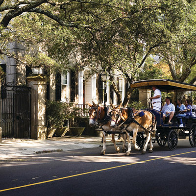
Could the Pimlico racetrack neighborhood look like this? (Horse-drawn rides are always popular.)

The city that revolutionized baseball at Camden Yards now needs an even more radical change involving the way people see horse racing at Pimlico. Historic Pimlico racetrack is already Camden Yards, Fenway Park and Wrigley Field rolled up in one. Now it's a matter of recreating a feeling that transcends history, that elevates us inside and outside the racetrack.

The geography of change


Pimlico's surrounding geography can fully cooperate. Much has been made of the contrast between white affluent Mount Washington neighborhood to the north and black lower income Park Heights to the south. But physically, the racetrack itself creates an east-west split, not a north-south split. Both the east and west sides of the track include sections of both Mount Washington and Park Heights, but the east side also includes the Levindale neighborhood just to the south, which is one of the most stable attractive sections of Park Heights, along with the large Lifebridge Health complex of the Sinai and Levindale Hospitals.

Distinctive and attractive genuine stone houses on Laurel Avenue in the Levindale section of Park Heights,
two blocks south of the racetrack property.


The track is physically hemmed in by two east-west arteries, major Northern Parkway and minor Belvedere Avenue, but not by north-south streets. The east-west divide could be dealt with by a wide attractive tunnel under the track linking the infield, which could also address Northern Parkway. Belvedere is narrow enough to pose no problem. Back in the 1970s, Pimlico Road was closed through the racetrack site and replaced with Preakness Way farther east. There is nothing permanent about this, however, and there is flexibility to reconfigure the street system to integrate the track with its surroundings.

Oriole Park at Camden Yards taught much about this in the 1990s. The adjacent Ridgely's Delight and Otterbein neighborhoods see Camden Yards as a unique asset. Parking can be taken care of with residential permits, although for an annual event as huge as the Preakness, the neighborhoods participate fully as resident hosts, embracing rather than shunning their outside guests. Parking can be managed. It is absurd for economic development "experts" to use parking as a primary criterion for urban vs. suburban racetrack comparisons.

And building luxury suites? They're soooo 1980s. Yeah sure, if some rich guys want to shut out the crowd and encapsulate their entourages in private cocoons without participating in the action and interaction, that's fine. They even provide big screen TVs, as if recreating the feeling of a club basement "man cave" is the goal. But luxury suites have nothing to do with the overall experience at Pimlico, Laurel racetrack or anyplace else - not even at allegedly "state of the art" Churchill Downs or Jerry Jones' Dallas football palace. They're an irrelevant oxymoron that's just hanging on like "Reality TV".

The time is over when suburban places like Laurel are seen as the solution to urban problems. So when will we learn? Back when horses rather than cars were dominant in cities, pollution was just the mundane stuff on the street you accidentally stepped in. And a "stable neighborhood" referred to the horse houses behind where the wealthy lived.


But now in ironic postmodern times, it may be possible to create a lucrative niche real estate market where the romantic equestrian clippety-clop is a common sight and sound in front of your house. Such things have already happened in rural communities. So as often happens, cities are the final frontier. And where better to do it than as a backdrop to the Home of the Preakness, second jewel of thoroughbred racing's triple crown?

Image result for urban horse riding
Here's what a horse neighborhood could look like. Imagine this as a Pimlico backdrop.

South Mount Washington: Putting the horse before the cart (or car)


So here's the concept: Create a new kind of neighborhood just east of the racetrack that would be physically integrated with both Mount Washington to the north and Park Heights to the south, but with a totally unique environment.

While much is made of black vs. white, here horses would be #1 and humans would be #2, regardless of breed. Everything would be optimized for horses, so all the issues of animal rights activists would be addressed. The mundane ramshackle horse stables that currently flank the racetrack periphery would be replaced with stables of suitable grandeur. Horse-people would then live above them, just as they did in the 19th century.

Street surfaces would be horse friendly. Traffic speeds would be governed by the horses, just as they are by the culture in Amish country.

This could be a "gated community" for the purposes of keeping the horses inside, rather than with any of the usual exclusionary connotations. Well designed entrance gates would also actually become an attraction of their own, since they would be the focal point at which the neighborhood reaches out to its surroundings. Additional suitable security measures to protect valuable thoroughbreds would also be implemented. (In horse culture, it's not yet politically incorrect to say "well-bred".)

Looking south toward the dense wooded periphery of the racetrack site just east of Preakness Way (seen to the right).
This woodland would be ideal for a "bridle path" to ride horses eastward to Cylburn Park.

Pimlico Road should be reopened in some form to provide the greatest integration with the racetrack and the surrounding communities. A strong neighborhood interface with the Lifebridge Health complex should also be created, including common use of its attractive densely wooded green spaces, which should be expanded by replacing some of its parking lots with structured parking. A bucolic "bridle path" through this area, eastward to Cylburn Park, would also be a great addition.

Proposed South Mount Washington "horse neighborhood". Existing rows of stables
are to the left, adjacent to the racetrack. Proposed "bridle path" is shown in orange,
from  Preakness Way east to Cylburn Park, just north of the Levindale Health Center.
The Mount Washington neighborhood is to the upper right. Park Heights neighborhood is to the bottom. 

The name of this new equestrian neighborhood should be decided by the real estate experts, but "South Mount Washington" might be appropriate because it already lends cachet and value (cache?cash, eh?) as the identity of one of the city's most rustically attractive neighborhoods. (No offense, Park Heights, you benefit as well.)

The area's new 21st century amenities, geared to larger crowds of jobs and visitors with more general purposes, would be focused on the area west of the racetrack, north of the intersection of Park Heights and Belvedere Avenues.

Living in South Mount Washington would not be for everyone. It would be for horse people. But urban living in general is already increasingly a niche market as suburbs dominate demographics. Economic development also calls for far different measures in different places, like Pimlico and its suburban rival in Laurel. Just as Pimlico's Preakness is unique as the middle jewel of the triple crown, there would be only one South Mount Washington neighborhood.

Image result for urban horse riding
Horses from the Pimlico horse neighborhood could serve as ambassadors to the surrounding neighborhoods.
This may also create a viable and acceptable way to resurrect the "A-Rab" produce carts.

It would spread some of that Preakness feeling over the other 364 days a year, although people probably wouldn't wear those crazy Preakness fashions every day. By celebrating horses, both at Pimlico and its surroundings, we would all get beyond ourselves to celebrate, strengthen and revitalize life as a whole.

May 16, 2017

New bi-level Pimlico: Racetrack-infield-neighborhoods

Here's a plan to fix Pimlico Racetrack by turning part of it inside-out, thus transforming the teetering  home of the Preakness into something that has never been seen before - while preserving everything that makes the track a historic legend.

The racetrack's biggest complaint is that it's located in a bad neighborhood. This is wrong, but it's a major perceptual problem that could nevertheless lead to its demise.

Lush lovely Ken Oak Road looking west toward Pimlico Road in Mount Washington, only a block north of the racetrack.
The large attractive houses are set back so far from the street trees that you have to look hard to see them.

The solution is to rebuild the existing track as proposed by the Maryland Stadium Authority, but with one key difference: Simply lower the a wide prominent portion at the north end so that it goes under the track and integrates the infield with the rest of the site to the east and west. The vast infield area, which is now connected only through a narrow dank tunnel, would then become a central focus of the entire racetrack site.

The new orientation and grading would mean the infield would no longer feel like an afterthought. Instead, it would be a highlight - just as it already is for the hundred thousand patrons who attend its party once a year on Preakness Day. The infield and its lower corridor connections would then be integral parts of the expansion of Pimlico into a full-time, multi-use activity center for the community, the city and the region - with horse racing as its theme and motif - as recommended in this previous blog post.

Here's the most audacious idea: Relocate Northern Parkway so that it runs through this below-grade corridor underneath the racetrack. Everyone driving on Northern Parkway every day would get the Pimlico experience. And the traffic flow would instill life and movement to the track even on days when there are no events.

Now here's the best part: With Northern Parkway relocated below-grade, it would no longer be a major barrier between the racetrack and the Mount Washington neighborhood to the north. While the most often cited criticism of Pimlico is about its surrounding neighborhoods, this really refers to the lower income Park Heights neighborhood to the south. What is seldom mentioned is that Mount Washington to the north is actually one of Baltimore's highest income neighborhoods.

This distorted narrative actually suits a narrow agenda of some who desire the racetrack to remain a barrier between the two disparate neighborhoods. But it's very harmful to the larger interests of the city and region as a whole. The common view in both neighborhoods that Pimlico must succeed in order for the surrounding areas to succeed. The only real alternative is to close down the racetrack and turn it into an empty development site and a blank slate. That's a can of worms and pitfalls that no one has ever been able to address. What would replace the racetrack?

Bi-level Pimlico Plan: The blue line is the realignment of Northern Parkway between Key Ave (left, west) and
Preakness Way (right, east). The yellow land areas would be excavated in a tapered manner to create a wide corridor
to and through the racetrack infield (center). Mt. Washington is the neighborhood to the north (top).

Conceptual possibilities


Since the Maryland Stadium Authority is currently studying rebuilding the racetrack virtually from the ground-up, going below the ground would not add significantly to the disruption or even the cost. There are many conceptual possibilities, but here's one way a bi-level Pimlico could be designed.

The re-grading would roughly encompass the area between existing Northern Parkway and the north circle of the racetrack oval inside and outside the infield. The track itself would remain just where it is now.

Northern Parkway would be lowered and shifted southward between about Key Avenue to the west and Preakness Way to the east.

The re-grading would be tapered gradually in most places, to create an airy, open, accessible environment. Existing Northern Parkway would remain in place as a local street for the Mount Washington neighborhood, but with far less traffic. The digging would be deeper to the west because the land is flat. Northern Parkway is on a hill to the east.

The "tunnel" under the racetrack which would connect both sides to and through the infield would be as wide as necessary so that it can be designed to not feel like a tunnel at all. The northern edge of this tunnel would contain the relocated Northern Parkway, which would be narrowed from six lanes and a median strip down to four lanes (44 feet) or perhaps only two lanes if enough traffic still uses the existing upper Northern Parkway, including all traffic that wants to access the neighborhoods and the racetrack site.

Designers would no doubt rise to the challenge to make the grade changes as interesting as possible. The taper in the infield could contain a stage for performance events during the Preakness and the rest of the year. The taper next to the main grandstand west of the infield could be integrated into a new below-ground concourse to serve race patrons.

With the diversion of the heavy Northern Parkway through traffic into the tunnel and away from the neighborhood, the interface between the racetrack and Mount Washington neighborhood would have an entirely new feel. Without the heavy thru traffic, existing Northern Parkway could be made to feel similar to the slow elegant parkways inside the neighborhood, like Ken Oak Road (pictured above) and Cross Country Boulevard. On the south side of the street, the racetrack or its multiple new uses could be oriented to feel like they are directly associated with upper-crust Mount Washington, reinforcing the image of horse racing as "the sport of kings".

Since the established boundary of Mount Washington is in fact Northern Parkway, the neighborhood would essentially be expanded by a block to the south of the existing roadway, and the new development on this land would be Mount Washington development.

This design would also enable the Park Heights neighborhood to the south to be integrated as well, with a gradual transition northward to Mount Washington instead of the current abrupt border feeling. Like in Mount Washington, the racetrack plan would essentially expand the Park Heights neighborhood toward the racetrack, especially near the central intersection of Park Heights and Belvedere Avenues. Unlike in Mount Washington, however, pretty much all previous racetrack plans called for this change. However, until now, there was never a strong enough justification to actually do it.

Most importantly, the racetrack needs to be reinvented as a year-round attraction. All the raw material to accomplish this is there, most notably the rich historic legacy and the eager host neighborhoods where life already happens every day.

The current Pimlico planning process is the city's last best chance to do it right.

May 2, 2017

North Av/Reservoir Hill riot redux: Don't blow it again!

On North Avenue, less than a mile east of the center of the 2015 riots, the redevelopment that happened after the 1968 riots has just been knocked down so it can be redeveloped yet again.

The 1970s Madison Park North development was notoriously nicknamed "Murder Mall" for its chronic crime. It was arguably the most awful new design anywhere in Baltimore in the past 50 years - a bad shotgun wedding of urban and suburban style elements. While the rest of the Reservoir Hill neighborhood has since recovered well, if slowly, the only recourse remaining for Murder Mall was its recent demolition.

Beautiful Bolton Street in Reservoir Hill, looking south directly at the rear of the last remaining structure in Murder Mall. 

In fact, the stately century-old rowhouses on adjacent Bolton Street just north of the site in Reservoir Hill, once largely in shambles, now look just about as well preserved as its mirror image blocks to the south in "blue-blood" Bolton Hill, which have been almost continuously prosperous since the nineteenth century.

Unfortunately, despite Reservoir Hill's recent success and the fact that the 2015 riots missed this area, it's all-too-easy to envision the same mistakes being made again in the new redevelopment. But the one clear tool to making the plan work may be to redesign this portion of North Avenue itself, which now acts as a formidable geographic barrier between the old-guard Bolton Hill and newly-emerging Reservoir Hill neighborhoods.

The Murder Mall demolition site, looking east. Reservoir Hill is to the left (Lennox Street)
and in the background (Park Avenue). The site's lone remaining structure is to the right.

Redevelopment as it looks so far


The fate of Murder Mall demonstrates the ruinous power of bad design. And it's not just high rise low income "projects" that become doomed. Innocuous low-rise "mixed use" (often seen as a panacea) development such as this can be doomed too, if the design is bad enough.

I won't enumerate the crime history or all the design sins of Murder Mall. It's pretty much gone now. This isn't a design blog anyway. It's a planning blog, so it's time to look toward the future, not the past, as Mayor Pugh would say.

And there are a lot of intelligent people with an interest in the Murder Mall redevelopment project, either as hired professionals, nearby residents, stakeholders or interested bystanders. So I'll let them do their thing and see what they kind of design come up with.

But for some reason, I'm nervous. So far, the posted website is just about a total blank. It doesn't even say whose website it is. It only asks you to tell them your email address, just like any two-bit internet hustler. This is a bad sign.

On the other hand, the website's only picture is of those beautiful rowhouses nearby - an effective attempt at tacit reassurance that they know what an asset the existing neighborhoods are to the project, and that they will hopefully try to compliment them in the new design.

But there's also a rendering of a redevelopment scenario posted in various other places, which looks like a high budget glass version of Murder Mall, defying anyone to break the glass and start another riot. This glass style reminiscent of "star-chitect" Mies van der Rohe was fashionable at the same time in the 1960s when the ghetto bunker-style Murder Mall was built. Can't we get out of that era? Oops, newer post-modern architecture is often not relevant either.

Madison Park North Redevelopment Will 'Create Something Transformative For West Baltimore'
The first rendering of the Murder Mall redevelopment stands out with 1960s modern international-style architecture,
but with a similar "superblock" layout and North Avenue essentially unchanged in the foreground.

Contradicting all that, the largest building in Murder Mall has not yet been demolished. With everything else gone, this building just sticks out and would block any reconnection of the single remaining block of Bolton Street in Reservoir Hill. Keeping this building is the main thing that prevents the site's reintegration with the communities and creates a "superblock" fortress environment that was one of the primary reasons Murder Mall was such a disaster in the first place.

But that remaining building is a usable shell for a new supermarket, which seems to be what the surrounding communities want most, even though it is the land use with the most suburban roots. A supermarket is what debates over the nearby State Center project have talked about most, even though its really big issues are the massive guaranteed state government rent payments and the need for transit-oriented development.

On the plus side, the rendering suggests that such a supermarket would be integrated creatively if it was to be included in the project, rather than just occupying the same old failed building. The rendering's architecture also suggests an emphasis on uses other than residential - meaning retail and jobs, the two things needed most. There's already plenty of residential in the surrounding areas.

On the minus side, the rendering also shows existing North Avenue retained in pretty much the same oppressively wide suburban way as it was rebuilt after the 1960s riots. Mixing urban and suburban style environments is a strategy fraught with pitfalls. That might be the largest lesson to be learned by the failure of Murder Mall.

That also describes the pitfalls of the redevelopment process. Recreating suburbia won't work, but suburban models are what are most successful... in suburbia. People just want a supermarket, rather than getting hung up in issues like architectural styles, urban versus suburban, and superblocks versus grids.

Bottom Line: Blending in


The simplest way to express the lesson which must be learned is this: The project needs to blend into the beautiful successful neighborhoods to the south and north - Bolton Hill and Reservoir Hill. Because of the surrounding neighborhoods' success, failure here would be all the more spectacular - unlike Old Town where the post-riot design was pretty decent in its own way but the surroundings kept it from working anyway.

Bolton Hill probably won't or can't be changed. They've already solidified their outer edge along North Avenue to turn inward. There's virtually no access to anything in Bolton Hill along the entire North Avenue border, except the intersection at Park Avenue (there always seems to be a "token"). It would be great to change that, but there are no "soft" properties where it could readily be done.

Of course, the Reservoir Hill neighborhood to the north also has its own internal agenda. It's a wonderfully diverse neighborhood that has accomplished much and needs to get along with each other to come up with some kind of united front for the project. The city needs to respect that.

That leaves North Avenue itself as the most likely instrument of change, because it's nobody's turf. Right now, it's nearly 100 feet wide adjacent to the site, even though much of it elsewhere is only 60 feet wide, and the two lanes in each direction which traffic ostensibly needs would only require 40 to 44 feet. That leaves a lot of leeway. On-street parking is also of little use here, unless the new development is designed for it.

Since the south (Bolton Hill) side of the street is likely already a "hard" impenetrable barrier, probably the best thing to do is to push all four lanes of through traffic to the south side. That would free up the north half (or more) of the roadway to be used to compliment the design of the redevelopment project. The most common and most urban way to do this is by designing a "service drive" to make the adjacent portion of North Avenue into a slow moving local street, rather than a main east-west artery.

Murder Mall before it was demolished, with suburban style housing
situated amid open nooks and crannies where crime happened.
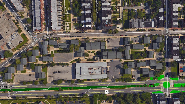
This "superblock" is bounded by North Avenue to the south, Park Ave. to the east, Lennox Street to the north
and Linden Avenue to the west. Bolton Hill is south of North Avenue and Reservoir Hill is to the north

Another more all-encompassing possible element would be to construct one or more roundabouts at key locations along North Avenue, such as Park Avenue (shown), Linden Avenue (at the southwest corner of the site) and Eutaw Place (further west). Roundabouts have the unique ability to interrupt major thoroughfares in a way that focuses attention on the local "place" instead of on an entire corridor, which can reinforce the barrier aspect. Roundabouts could also effectively sort out the conflicts of traffic turning into and out of the service drive.

A proposed North Avenue streetcar line, as has been discussed lately, but that would do exactly the opposite, so it's hard to see how that would be a successful catalyst for change.

Possible roundabout at North and Park Avenues. Development site is in the upper left corner.
West of the roundabout, North Avenue would be split with both directions of through traffic south of the median
and a local service drive north of the median.

In sum, the Murder Mall superblock was a product of the demolition frenzy of the early 1970s that also included the widening of North Avenue to make it even more of a barrier between Bolton Hill and Reservoir Hill than it was before, and even though urbanist Jane Jacobs explained a decade earlier the diametrically right way to do it and avoid border vacuums that breed crime.

The new development needs to unify communities, but this may be as difficult to do in the current age as it was in the riot-torn 1960s. Changing the design of North Avenue may be the one effective action in "neutral territory" that everyone can agree on to bring people together.