December 19, 2018

Pimlico poised to repeat success of Camden Yards

Populous, the lead planner for the new Pimlico Racetrack, is the same firm that designed Oriole Park at Camden Yards in the late 1980s. That's the ballpark that revolutionized baseball, and now along with a planning team orchestrated by the Maryland Stadium Authority, they're set to do it again. The key is planning for real people in a real community and city, not just for horse players.
The proposed Pimlico plan, oriented to the local street grid and providing numerous development sites.
Northern Parkway and Mount Washington are to the left (north), while Park Heights is to the top,
 beyond Belvedere Avenue and to the right beyond Winner Avenue. 

The new Pimlico plan is a recognition of economic reality, not some romantic notion of what horse players want or just another huge politically driven subsidy giveaway. Such a subsidy giveaway is what happens now at the Laurel Racetrack, where a tiny portion of the public gets big league subsidized prize purses for its minor league sport. History and need demand that money and attention should be rightly directed to Pimlico.

The Preakness drives everything


The real big money action is with the Preakness Stakes, Baltimore's annual Super Bowl of horse racing that attracts world-wide attention. In contrast, the rank-and-file horse players see The Preakness as just a diversion. But to the public at large, and the people throughout the nation and the world who define Maryland's public image, the Preakness is everything. So The Preakness is what defines and drives the new Pimlico plan.

Yes, the Preakness is only once a year. Therefore, Pimlico should be redesigned for activities that cater to people who want to be at the home of the Preakness on the other 364 days, not just to people who want to attend horse races on some of those 364 days. That's the huge distinction.

The Stronach Group can continue to run Laurel Racetrack for its small niche of horse players if they wish, but the State of Maryland needs to put its dedicated subsidy money into Pimlico, driven by the annual world class Preakness event. Or Stronach can support Pimlico with this funding instead of Laurel. Either way, the state's subsidies will support the Maryland horse industry and the world class Preakness event that drives the city and state's image.

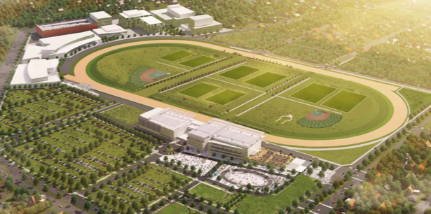
The Pimlico plan, showing the racetrack related infrastructure, including the multi-purpose clubhouse
and streets that would extend thru the track infield when not closed for events.
Also shown to the upper left is a concept for the Lifebridge campus extension into the site.

Pimlico's geography


Currently, Pimlico has an image of being in the midst of a scary crime-ridden ghetto, but this is totally opposite from what the area's inherent geography provides, which is ripe for redefinition. The race track is currently just plopped down in a manner that isn't oriented to anything, so people create geographic associations in their own minds. The Park Heights neighborhood is nearby and regularly gets bad publicity when bad things happen, so Pimlico's image suffers in tandem.

Of course, that's a huge problem with Baltimore in general, and the only way to fix it is to actually make the geography work better. Just like Pimlico, Baltimore has areas with better images and with worse images. Pimlico happens to be adjacent to the affluent Mount Washington neighborhood, the prosperous Sinai/Lifebridge health campus and the unsung but beautiful Levindale neighborhood. Even the Cylburn Arboretum, Jones Falls Valley and the city's premiere Roland Park neighborhood are relatively close and can provide support. These provide the raw material to make the geography work.

In my previous Pimlico posts, I tried to devise ways to reorient the racetrack to take better advantage of its geography, but I missed the simplest and most direct way to do it. I assumed that the orientation of the track itself was fixed, in order to retain any remaining historic architectural elements which may need to be preserved.

But the Pimlico planning team and its plan participants wisely concluded that the most crucial part of its history was simply being where it is - the geography. It is the land itself that is special and unique to the century of history for which Pimlico is known.

All the planners had to do to take advantage of that was simply rotate the racetrack by 35 degrees, to reorient it to the surrounding urban street grid, so that a development plan could be devised to create suitable transitions to the communities. That way, all that is good and special with Pimlico and with the communities can flow together. The history of one becomes the history of all.

Pimlico site plan, showing proposed development and streets through the infield. "P" is retail center off
Park Heights Avenue, "O" is residential off Belvedere Avenue, "Q" and "R" are related to Lifebridge Health Campus.

There are numerous design elements which can be used to promote this. Most fundamental is the extension of the urban street grid into the site in all directions so that they become truly integrated. This includes a ring road that is concentric to the race track itself, so that anyone on the site can become fully conscious of the track. The streets will even be extended across the track into the infield area, which will become the prime parkland and recreation area of the surrounding communities. All of this will be designed so that all elements can be closed as necessary for events, especially the Preakness of course.

The second crucial design element will be the design of the clubhouse itself, which will be the critical central "anchor" for various events and activities all year around, for anything that wants to take place in an environment where sacred horse racing history took place.

There will also be specific uses, like retail, offices, a hotel and the Lifebridge health complex which takes advantage of the fact that Baltimore is known for its world class health care industry. Much still needs to be analyzed regarding this, of course. Lifebridge would be responsible for its own land use planning, which is not addressed in the current plan. Care must be taken by Lifebridge to avoid the egregious mistakes that Johns Hopkins has made with its physical campus planning that resulted in a fortress mentality and alienation of the surrounding communities. The bottom line is the creation of sustainable jobs and economic development.

Many people have suggested that all this development could happen without the racetrack, but in that case, this would be just another big vacant lot in a city that is full of them. There would be no particular reason for people or businesses to locate here rather than somewhere else, like the suburbs. But being part of the Pimlico racetrack campus is priceless.

Comparison to Oriole Park at Camden Yards


Back in the 1980s, Populous was known as HOK and had just come from planning the new Comiskey Park for the Chicago White Sox, when it was selected to plan Camden Yards. The Chicago stadium plan was the typical "giant ashtray" plopped into the site in a way that totally alienated it from the surrounding communities. Unfortunately, the initial concepts for Oriole Park at Camden Yards were the same concept. Even the distinctive historic thousand foot long B&O Warehouse, which ultimately became the signature design element of the stadium, was eliminated from the plans. This was simply considered the accepted thing to do at the time.

But everyone wanted something better. Spending a day at the ballpark should be far more than just about the baseball game. It should be a communal experience, with other people and with the city itself.

The rest is history. The stadium was designed around the warehouse and oriented to the street grid and the downtown neighborhoods. Instead of a generic round ashtray, the stadium fits into its space with distinctive angles and facades. It's not a historic stadium like Wrigley Field or Fenway Park, but it's a historic place, which is even more crucial.

A whole new breed of ballparks has followed suit, but Camden Yards was the first and most distinctive. Promotion doesn't just focus on the Orioles (which is fortunate considering how bad they were this year), but on "Birdland", the stadium place itself. Fans come from all over the country and even the world to experience Camden Yards. Its sometimes a bit unnerving to see so many excessively exuberant Yankee and Red Sox fans, but they spend money in Baltimore and help the local economy.

More lessons have been learned in designing sports stadiums around the country since then, and Oriole Park has not done a great job of exploiting related development opportunities surrounding the ballpark. The Hilton Hotel is not admired much, and the Middle Branch Gateway Entertainment District has not been very successful yet, unless you call Royal Farms-style gas convenient stores a success.

But now at Pimlico, Baltimore has another prime opportunity to do it right and make history again. It's not just about horse racing or baseball, it's about urban life.

>>> Selected previous Pimlico and Camden Yards posts:

https://baltimoreinnerspace.blogspot.com/2017/05/stable-pimlico-neighborhood-for-one.html

https://baltimoreinnerspace.blogspot.com/2017/03/fix-pimlico-and-preakness-shutdown.html

https://baltimoreinnerspace.blogspot.com/2011/08/camden-yards.html

November 27, 2018

A Shot Tower Maglev station would transform the city

There is one potential station location for the proposed high speed MagLev system that would change the way people along the entire east coast see Baltimore - especially Baltimoreans themselves. It's a station that could be at the intersecting point of the existing east-west Metro subway and a much faster spur of the city's north-south light rail line. It's a station that could also add 15 acres of new prime developable land to what could be the fastest growing part of downtown.
Footprint for proposed MagLev Station shown in blue, now the central post office, at the
 south end of the Jones Falls Expressway (shown at right). Metro subway is in green under Baltimore Street.  

A brief local history


This potential MagLev station site is at the foot of the Jones Falls Expressway and the Shot Tower Metro Station. This location has great access and was originally supposed to be a key part of downtown and a gateway to the Inner Harbor, but that never happened.

In the 1980s, Mayor Schaefer decided the open portion of the Jones Falls should become "Fallswalk",  patterned after the highly successful riverfront promenade in San Antonio, Texas. Some ambitious plans were carried out, including the Children's Museum in the grand old fish market, as well as "The Brokerage" shopping mall in the building which now contains the Rams Head Live music venue. But then in the 1990s, the police headquarters decided to use the closure of Baltimore Street to build the Metro to create its own permanent dead-end parking lot. When the Metro station finally opened, the MTA didn't even bother to return the bus service to the adjacent section of Baltimore Street, further isolating it. In 2001 after 9/11, the police decided to go a step further and make Baltimore Street into a secure "no man's land" where even pedestrians were prevented from approaching the Metro Station for several years.

The most conspicuous insult added to injury was that a very cool helium balloon tethered ride which had been erected above the Metro Station entrance had a mishap, where the balloon and its riders got stuck for many hours several hundred feet above downtown. That was pretty much the last straw. What was supposed to be a future high-rise "air rights" development site became just another ad hoc parking lot for whoever has the clout to park there.

While people often talk about the abject failure of transit-oriented development on Howard Street and other places, the Shot Tower Metro Station should also get an honorable mention. But just as on Howard Street, the seeds of failure were planted much earlier. People had unrealistic expectations when this portion of the Jones Falls Expressway was built in the 1980s as an at-grade boulevard (President Street) with the Jones Falls stream uncovered. (Unfortunately, that's a concept that refuses to die as some "visionaries" still want to tear down the expressway northward past the prisons.)

Simply put, the highway wasn't built to a pedestrian scale, and it probably never will be.

The real key is getting rid of the regional post office


But the expressway didn't even start the anti-urban trend in this area. That role could go to the 12-acre central regional post office built in the early 1970s adjacent to what later became the expressway. A regional post office was a bad anti-urban land use choice - a massive fortress that generates a huge amount of truck traffic. Its architecture also reflects this, being just about as brutal as "Brutalism" can get. This regional post office should be moved out to the suburbs or the city's outskirts.

The site would then become the ideal location for the city's Magnetic Levitation system station, with all the grandiose urban architectural gestures that such a revolutionary transit mode would justify.

Train stations have historically been the places where cities have put their civic pride on display to the most conspicuous extent possible. And now New York City happens to be doing it again with the redevelopment of their central post office into the Moynihan Train Hall, as they finally atone for the sin of tearing down their glorious Penn Station back in the 1960s.

Image result for moynihan train station images
Future New York train station on site of former central post office, across the street from the current Penn Station.

This kind of ostentation will be even more crucial for the northeast corridor MagLev line, the vast majority of which will be underground and thus provoke no sensual stimuli other than pure speed, up to 300 mph.

Riding MagLev into Baltimore should be a major event. It should leave no doubt in riders' minds as to where they are. Baltimore's boosters must understand this on some level, based on the jumbo video screen they've installed on the train platform to hype-up the city at Penn Station.

The scale of the adjacent JFX, aka President Street, cannot be reduced to human scale, so the scale of the humans must be expanded to meet the challenge.

The scale of MagLev itself also fits this formula. It's passenger platforms will be over 1300 feet long, compared to the planned Red Line light rail's platforms of less than 200 feet. The tunnel excavation for each MagLev station, where the "top down" construction technique is deemed necessary rather than a conventional "boring machine", is planned to be over 3200 feet long.

Perhaps most importantly, the MagLev station would fill a gaping hole in the urban fabric of what is otherwise a very fast growing area of on the east edge of downtown. Development is now spreading northward from the "New Downtown" at Harbor East and westward from the Johns Hopkins Medical campus to Old Town. The post office would not only be replaced with a MagLev station, but also great high density accompanying urban development such as offices, residential and retail uses.

Map view of proposed MagLev Station adjacent to intersection of Metro (green) and
proposed central light rail extension (orange) from Penn Station to the north to Harbor East to the south (bottom).

Rail transit connections


Another Baltimore failure has been its inability to fulfill the 1960s vision of a central rail transit hub station, where high quality east-west and north-south lines would meet. The Charles Center Metro Station was supposed to be that station, but the existing Metro has become pigeonholed as more of a minor low-ridership northwest line. Meanwhile, it is now realized that a proposed central north-south spine line to Towson would end up costing many billions which simply can't be justified.

So in the 1970s, a far cheaper light rail line up the Jones Falls Valley to Timonium and Hunt Valley was planned. This was originally to extend all the way down the valley to the east side of downtown. It was finally built in the 1990s, but to Howard Street on the west side instead.

Then a funny thing happened. As the light rail line was built to link the west side, downtown itself drifted eastward. And not only did jobs and retail abandon the west side in droves, but the light rail line itself proved immune to all attempts to run at a decent speed.

So with the explosive growth and expansion in Harbor East, along with a possible MagLev station, now is the time to revive the original plan to extend the central light rail line all the way down the Jones Falls Valley from Penn Station. The speed of the two mile segment from Penn Station to the MagLev Station would be quick, with very few traffic conflicts and probably only one intermediate station under the expressway at Centre Street to serve Mount Vernon, Old Town and the new development on the Sunpapers site. The cost would also be reasonable.

The demolition of the post office would also enable the MagLev and light rail stations to be integrated as seamlessly as possible, taking advantage of the direct underground connection to the Shot Tower Metro station which already partially exists.

South of this point toward Harbor East, however, the light rail line would run into some serious traffic conflicts on President Street, so careful and creative planning would be necessary. But it would be worth it. Even a slow light rail line for this last half mile to the Inner Harbor and Harbor East would add greatly to its value. Another possible concept would be to end the high capacity light rail service at the MagLev and Metro Station and simply run streetcars beyond that point, with both services overlapping to Penn Station.

MagLev Station footprint in blue, Central light rail extension in orange and Metro subway in green.
View is looking south toward Harbor East at the top.

MagLev Station Alternatives


When measured by the station location criteria in the latest MagLev study report released this month, the Shot Tower / Post Office site comes through with flying colors.

Prior to this report, station locations at Penn Station and Harbor East had already been rejected. There is an inherent geographic problem with Penn Station in that "geometry precludes a feasible route to the northeast", as stated in the report. In other words, Penn Station is simply located too far off the straight high speed path from Washington to Philadelphia and New York. That's a fatal flaw.

Both Penn Station and Harbor East also suffer from "complex construction challenges" as the report states it. This basically means that there isn't enough land available anywhere to excavate the station and provide access for the very long and deep tunnel boring process that would be necessary. This is particularly a problem at Penn Station because the route alignment would be on an angle tilted to the northeast, which is not amenable to the shapes of any parcels that would be available.

This is also a problem for all the station sites in the "Downtown Station Zone" defined by the report, including the Inner Harbor and apparently the Mechanic Theater site which I had proposed here. According to the study, it's somewhat less of a problem, but still an issue, in the Camden Yards/Convention Center site that has been retained in the screening process.

Finally, the Harbor East site suffers from "intermodal connectivity constraints" as stated in the report, which is another way of saying it has insufficient traffic and transit access.

The Shot Tower / Post Office site solves all these problems. A nice gigantic hole in the ground of 10 to 15 acres could be dug to fulfill all the construction needs. The route alignment angle would create a virtually ideal path toward Washington and on to New York. There could be direct access to an interstate highway and two direct high quality rail transit lines, located near the geographic center of the entire metropolitan area.

Closer view looking south down President Street extension of I-83, with post office in the lower left
 next to historic St. Vincent DePaul Church (white tower) and Shot Tower (brown brick tower).
 South of Baltimore Street (green) are subway entrances on both sides of President Street, which can also serve as
MagLev Station entrances. The one to the right (west) has direct access to the Inner Harbor along Market Place.

The Maglev Alternatives report suggests that engineers have been far more dominant over the planners than they usually are in this type of process. After all, nobody in these parts has ever built a Magnetic Levitation line before, so questioning engineering judgment is risky. Our MTA did try to design such a MagLev system back in the 1990s, but the result looked too much like a 40 mile deluxe version of their 18 mph Baltimore Red Line plan rather than 300 mph high speed transit. Both projects met the same fate of failure.

So now it is time to expand our horizons and give MagLev its rightful place at the top of the transit hierarchy - which ranges from light rail to heavy rail Metro to MARC to Amtrak to hyperloop and on up to MagLev.

Baltimore needs to build a MagLev Station which is befitting of our city's special role between Washington, Philadelphia and New York? The Shot Tower / Post Office site offers the best location to make it happen.

November 14, 2018

With Amazon HQ2, MARC should be extended to Virginia

With Amazon's newly announced Northern Virginia Headquarters 2.1, Crystal City will now start to displace the District of Columbia as the "New Downtown" for the entire Washington metropolitan area. That includes Baltimore. So Amtrak's Northeast Corridor must be extended from New York to beyond Washington, DC - into Virginia. And just as surely, the MARC Commuter Rail "Penn Line" must also be extended from Baltimore and DC into Virginia as well.

Currently, trains from Baltimore and New York must undergo a cumbersome and time consuming switch from electric to diesel locomotives at Washington's Union Station in order to proceed southward to Virginia. This will no longer be acceptable. It must go "all electric".
Extension of MARC "Penn Line" from DC Union Station to the Amazon Crystal City Headquarters
 in Arlington, Virginia and three nearby stations, made possible by electrification of the Amtrak line. 

Baltimore and DC will both be suburbs of Northern Virginia


The new Amazon headquarters in Northern Virginia (let's call it NOVAmazon) is actually destined to live up to that often abused term - "game changer". It will accelerate changes in the roles of both Washington and Baltimore in the urban hierarchy, and bring all of them closer together - hence the need for a transportation link that is best capable of connecting it all.

NOVAmazon is just the tipping point. The sprawling nature of the federal government and the 130 foot (thirteen floor) DC building height limit have long doomed the Washington metropolitan area to outgrow the District of Columbia as its central business district. So now the transportation system must now keep up with the inevitable.

Ironically, the District of Columbia will now become more like what Baltimore has also been becoming - just another node in the great Northeast Corridor megalopolis. As such, the distinctions between cities and suburbs have been getting a bit blurred. DC's wide avenues and expansive National Mall have long had a slightly suburban quality compared to Baltimore's intense gritty urban feeling. Throughout most of our country's history, Baltimore was much larger than Washington, which was always a relatively sylvan campus whose virtually only reason for being was as a setting for federal lawmakers and culture.

Now both Baltimore and Washington will be subordinated, relative to Northern Virginia. The big difference is that Baltimore is currently nearer to the bottom of the pecking order. Baltimore has already had time to get accustomed to the role of being a small fish in a big pond, and this is just another step.

Extending the northeast rail electrification southward will allow Baltimore to maximize its suburban spin-off from the Amazon move. Among other groups, this will include Amazon commuter employees, contractors and vendors as well as other people who just want to expand their horizons to what Baltimore has to offer, like BWI-Marshall Airport (which will be easier to get to than Dulles even with its new Metro extension.) Mostly, people will be trying to get away from the Washington area's sky-high cost of living, which is bound to get even higher. There has been lip service about this for a long time, but now is the time to get serious about takking advantage of Baltimore's lower cost of living, especially in West Baltimore, which is now the frontier. New MARC Stations at Sandtown, Upton, Mount Royal and Violetville could join the existing West Baltimore Station near the "Highway to Nowhere".

New rail relationships between Amtrak, MARC and VRE


The electrification will enable many MARC trains from Baltimore's Penn Station to extend their runs beyond Union Station to the current commuter rail stations at L'Enfant Plaza, which is farther into the heart of Downtown DC and has connections to four Metro lines instead of just one. Then the trains can proceed into Virginia to Crystal City and Alexandria, and most likely a new commuter rail station at Potomac Yard in between, which will likely experience the most dramatic growth from the new Amazon presence.

Maryland's MARC Commuter Rail line may be poised to take more advantage of the new travel patterns than either Amtrak or Virginia Railway Express (VRE). All Amtrak trains in this corridor traverse the entire corridor to New York or beyond, so they will have less flexibility to increase service in response to ridership growth at a specific location, even one as meteoric as anticipated from NOVAmazon. Long distance Amtrak trains must also keep their station stops to a minimum. It's not likely Amtrak will add another stop between Union Station and Alexandria. In contrast, MARC could more easily make Baltimore to Alexandria its core corridor and better tailor service to specific local travel demand patterns.

MARC and the State of Maryland should actually be in a strong negotiating position on this. Amazon should make a big push for the extended electrification in order to link its Northern Virginia Headquarters 2.1 to its New York Headquarters 2.2. The funding would happen through Amtrak, while CSX owns the tracks and thus must also be satisfied. But MARC would reap much of the benefit.

The Washington Metro will likely to continue to be the transit mode which guides Virginia's high density urban growth, far more than VRE. Virginia has put a great deal of emphasis on development in the Silver Line Metro corridor from Rosslyn to Ballston to Tysons Corner to Dulles Airport, and there is no good connection from that corridor to Amazon at Crystal City. Building such a connection would be difficult and expensive and thus require great growth in that corridor to justify it.

VRE is more likely than MARC to continue its current role as a more traditional commuter rail service, with its two branches to Mananas and Fredericksburg deep in the Virginia sprawl country. So VRE will still clearly be somewhat on the fringe. As a telling example, their ticket operation currently isn't even integrated with Amtrak's. At DC Union Station, you can't buy VRE tickets from Amtrak vendors or machines. At the gate to VRE's station platform, there's a sign saying you must have a ticket to proceed through the door, but VRE's only ticket machines are beyond that gate door.

In general, rail service needs may even outgrow the arbitrary distinctions between Amtrak, MARC and VRE. A new regional transportation authority would integrate all three, along with SEPTA, NJT, etc. and even Maglev. No transportation should operate in a vacuum, and that includes the regional highways as well (see this blog post).

The new southern terminus of the electrified Northeast Corridor could be Lorton, Virginia, just south of Alexandria, where Amtrak has a large train yard where switching from electric to diesel locomotives could be done with less disruption and more efficiency. There's already a station there for Amtrak's Autotrain service to Florida, and this could be expanded to serve all other trains as well.

Many other capacity and flexibility improvements will also be warranted as development and ridership grows, but electrification is a start.

Back in the 1970s, Amtrak extended the electrification of its Northeast Corridor northward from New Haven to Boston to keep up with the times. So all this is nothing new, except for the extraordinary change and growth in the Washington-Baltimore region which is leading to it. NOVAmazon will be the key focus.

October 30, 2018

Baltimore's MagLev Station MUST be Downtown

The engineering report for the high speed Baltimore-Washington Magnetic Levitation train station alternatives will be released soon, with three basic options - two of which are merely waterfront development sites. Downtown is the only option which makes any sense, the only location where it can serve the entire Baltimore region as a whole and lead to broad-based growth.
Three candidate MagLev station locations: Only downtown would have integrated access to the entire city and region.

Baltimore was built around downtown. All the region's transportation infrastructure has always emanated from downtown, including the street, highway and transit systems. MagLev is supposed to revolutionize Baltimore's place and role in the U.S. Northeast Corridor with 15 minute travel to Washington at up to 300 mph and eventually to New York. The entire region must benefit from this, not just isolated places.

Port Covington and Westport, the two alternatives outside downtown, are isolated places - former industrial and railroad properties shielded by the waterfront. The primary reason they have been considered attractive for billions of dollars of investment by their developers, supported by the city taxpayers, is that they are separated from downtown.

Traffic access to both Westport and Port Covington are zero-sum games that rely almost completely on highways that are already at or near capacity. Westport's highway connections include at-grade railroad crossings. Port Covington's connections require relocating and expanding the I-95 ramps in a way that would simply reduce the capacity for through traffic.

In contrast, downtown is served by a comprehensive and open-ended transportation network - spokes on a wheel which extend outward in all directions. Development has always followed these spokes. MagLev would simply be a continuation of the historical development patterns that have always been the framework for the city's growth.

Every neighborhood in the city and suburbs is defined to a large extent by its geographical relationship to downtown. Growth areas of earlier eras such as Mount Vernon, Upton, Charles Village and even Govans are defined as being midtown and uptown. As downtown's roles have evolved over the years, these relationships have evolved with it. Major downtown redevelopments like Charles Center, the Inner Harbor, Harbor East and Harbor Point have in turn created challenges for these communities to grow as well.

But what would happen if suddenly, Westport or Port Covington became the primary focus? There is very little historic linkage between these areas and most of Baltimore. Some linkage can be created via the central light rail line, with perhaps a spur, but this is hardly the kind of comprehensive connectivity that would be needed. The geographic boundaries of Westport and Port Covington are both limited and finite.

Downtown is also the only place that has the kind of rich complex web of land uses, interests and ownership that can truly respond to the challenges of MagLev and ensure that its benefits are as broad based as possible. All interests would get to decide how they want to respond to take advantage of MagLev.

Westport/Port Covington development monopoly


A huge problem with Westport and Port Covington is that both are essentially owned and controlled by the same single individual - Keven Plank, founder and majority owner of Under Armour. That is far too much control to give a single person.

The first phase of Port Covington development is supposed to proceed in late 2019 or 2020 - a relatively low density mixed-use complex adjacent to the newly completed whiskey distillery on the waterfront. This would be followed by much more ambitious and higher density development later, anchored by a large Under Armour corporate campus, as defined by a carefully crafted long range plan which was developed to get approval for $660 Million in city Tax Increment Financing.

But recent events make this questionable. Under Armour's growth has recently plummeted. Plank was highly aggressive in attempting to woo Amazon in its current highly publicized HQ2 campaign. When that failed, Plank's development team reportedly put its hat in the ring for a new arena to replace the old Baltimore Arena downtown.

This kind of Port Covington one-track mentality definitely hurt the city's effort to attract Amazon. The city has many other great development sites.

And this would essentially have necessitated the carefully crafted Port Covington master plan to start over at square one. A MagLev Station would require the same. An athletic wear campus, whiskey distillery and medium density development would not be the best uses in proximity to a MagLev Station.

Westport's future potential would be even more constrained. Plank's development team has indefinitely suspended all the ambitious Westport development plans which were prepared by the defaulted previous owner Patrick Turner, and they are content to simply the large waterfront property sit vacant until they deal with Port Covington. But unlike Port Covington, there is a small adjacent moderate income neighborhood which has essentially been held hostage by this, victims of all this fuzzy future speculation.

The Westport community has been very open minded about preparing for future development challenges, working for years with Patrick Turner to create the best possible plans for all. But a Westport MagLev station would be beyond any small community's ability to plan for change. If Westport was chosen for the MagLev Station, the community would be turned inside-out overnight.

From the standpoint of MagLev's development impacts, Westport and Port Covington really can't be considered separately. Westport would be Port Covington's secondary real estate market, and vice versa, owned by the same Plank consortium. They are essentially the same alternative. And downtown is the only other choice.

MagLev for the masses


The need for MagLev to serve everybody cannot be overemphasized, and is a primary reason why the station must be downtown rather than on any isolated development site. It cannot be merely a plaything for the rich. Yes, some relatively well-to-do will use it to commute to Washington, but its role needs to go far beyond that, especially as it is eventually extended toward New York and elsewhere.

In determining how various income groups would be affected by MagLev, distinctions need to be made between development and transportation impacts. The limited finite geographical size of Westport and Port Covington means that high income people would be able to dominate the speculation. In contrast, downtown areas immediately around the station would be most attractive for the high rollers, but as distance increases in all directions, lower income folks spanning the entire region would be able to take advantage as well.

That brings us to income effects of the MagLev system itself. The huge multi-billion cost of MagLev is irrelevant to how it would stratify income groups. Capital cost is committed up-front and is a "sunk cost". This is now all rail transit works. When the cost of the proposed Red Line tripled, no one thought that would have an effect on whether rich people would ride it.

Once MagLev is up and running, the challenge will simply be to attract as many people to use it as necessary to fill all the seats. Naturally, if service is of a sufficiently high quality, rich folks will be attracted and the operators will try to set the fares to get as much money from them as possible. This is what Amtrak does with its Acela trains, which are barely faster than the regular trains (mostly by skipping stops) but have double or triple the fares.

This is also the same as the distinction between first class and coach air travel. The long-term trend has been for airlines to cater increasingly to the lowest class, with cheaper fares and treating the masses like they're crammed into cattle cars. Since the popularization of air travel in the 1950s, there has been only one major attempt at a service exclusively geared to the upper class - the supersonic Concorde, which was a total failure.

MagLev will be nothing like the Concorde, because it will be a truly high capacity mode of transportation. Its propulsion will be on the guideway, not on the vehicles, so operating cost per vehicle will be low, leading to a push to maximize the number of trains. So for the rich and not so rich alike, the high frequency of service will be at least as important as the speed.

Everyone will want to take maximum advantage of being able to arrive at the station whenever they please and board a train as quickly as possible, rather than being slaves to a schedule. Sure, there will no doubt be a high fare first-class service that provides priority boarding and nicer seats, and maybe free booze if there's time for it, but that's about the only extent of the class distinctions.

Amtrak will have to adapt as well, emphasizing shorter distance trips between stations that don't have MagLev. The distinctions between Amtrak and commuter railroads will then blur or even disappear. This is already apparent in Amtrak's long range capital improvement plan, which only attempts to raise travel speeds by small increments. Commuter rail ridership is already concentrated more on higher income groups, while less frequent riders cover the entire income spectrum. So the cheapest MagLev fare between Baltimore and Washington may eventually be not much more than a typical Amtrak fare. MARC may go to a single base fare no matter how many miles you ride, just like MTA buses.

So MagLev needs mass appeal, as much as any mass transit does. That can't be provided at Port Covington or Westport. It can only be accommodated downtown, where the entire regional transportation system converges.

Mechanic Theater station site looking west from Redwood Street across Charles Street.
The curved roof of the Charles Center Metro Station entrance at Baltimore Street is seen to the right. 

Best downtown station for MagLev and Hyperloop: Mechanic Theater site


The obvious location for a MagLev Station is the former Mechanic Theater site at Charles and Baltimore Street at the exact traditional center of downtown, right at the Charles Center Metro Station. Whenever the old Baltimore Arena is finally demolished, sooner or later, the station can then be linked to the central light rail line. Other good candidate sites may also be available, but they must be near the center of downtown.

The criteria for a station on Elon Musk's proposed "Hyperloop" system are pretty much the same, and the same station should be designed for both. It is now apparent, however, that Musk's business plan is to emphasize incrementalism in his proposed system, rather than attempting to build an expensive, high speed, high capacity line all at once. It is also increasingly likely that the initial segment won't serve Baltimore at all, and may be in southern California. So, there will be a "learning curve" before major decisions need to be made. This should complement MagLev quite well.

Musk's system will initially use slower "skates" that operate up to 150 mph, about half as fast as MagLev or Hyperloop, covering stations which are closer together and off the main "trunk" line. This would create more of a tree with branches than a single high speed corridor. Thus Musk's system could feed MagLev, the same way conventional transit does.

Baltimore must prepare for the future of transportation no matter what eventually happens. The only way to do that is to plan for a high speed rail station in the heart of downtown.

October 17, 2018

Squeegee scene solution: City at the crossroads

Downtown intersections are now a microcosm of life in the city, with everybody getting into the act - not just drivers, bikers, buses and pedestrians, but "Squeegee Kids", poor "homeless" solicitors and monitors from the presiding "ruling class". The basic rules are observed, ignored, debated, stretched to the limit or violated by all, but remain inevitable nonetheless. It all seems complex but it's really simple.
Lombard Street looking west from South Street through downtown. "Do Not Black Intersection" sign is overhead.
 All signals say green, but traffic is blocked enough so that pedestrians are jaywalking.

The life cycle is the traffic signal cycle


The basic pulse of the city is regulated by traffic signal timing. Green and red lights cue every actor in the street drama to move in and out of the action. Downtown street life in Baltimore is divided into discrete 110 second cycles in peak periods which each contain a green, yellow and red light for each direction.

The 110 second cycles provide some green time for traffic in each direction to move, but also quite a bit of time to stop. There's red light time when you're supposed to stop, plus additional time when you must stop because traffic is blocked.

Everybody uses this extra time for whatever they can. Through traffic must sit, or perhaps proceed into the intersection and block it. Bikes and scooter riders can swing onto the sidewalks and become pedestrians. Pedestrians can jaywalk. Some drivers may check their cell phones. And "Squeegee Kids" and panhandlers can go to work.

The city touted the benefits of its upcoming downtown traffic signal timing improvements which were supposed to go into effect before enforcement of the new "block the box" traffic violation rules, but has now apparently given up on that. So this week, $125 fines for motorists who find themselves stuck inside an intersection began, without the aid of new better signal timing. City officials merely whimpered when their timing tweaks failed this summer, so then they said they'd put it all back the way it was. That's no progress.

The problem is that in a tight urban street grid, traffic signal tweaks are a zero-sum game at best, much like most other programs that attempt to slice up the urban pie. Giving more green time to one street means less green time for the other street, and all streets carry users of all modes. It can't be done on an individual intersection basis either, since traffic flow must be measured by the capacity of the system as a whole.

But what really happened is that the city officials remained quiet until city drivers started to speak up in protest. That hadn't happened in a while. Bike riders, transit riders and pedestrians have all raised their voices - but not the "cagers", as the bike lobby calls people who sit in cars surrounded by a ton of protective "shiny metal boxes" (as The Police sang - not the Baltimore Police, but Sting and his band on the "Synchronicity" album).

At worst, many "cagers" reacted against the bike riders. That was not a smart move. Everyone is in this together. And on the Pratt/Lombard one-way couplet where traffic demand is heaviest and tempers are shortest, bikes are only allowed to use the bus lanes and are not given lanes of their own. Big buses win on the intimidation factor, while many bikers have become adept at weaving in and out of the bus and car lanes and sidewalks, as have riders of  the new motor scooters, while the "cagers" can only seethe with envy.

"Squeegee Kids" graduate from a short to a mid-term issue


The big benefactor of recent events will be the "Squeegee Kids" who wash windshields while drivers are stopped waiting at intersections. According to the law, these kids are illegal solicitors who violate traffic laws, as are the increasingly present panhandlers. But also starting this week, the Downtown Partnership plans to place security guards at intersections to "monitor" the actions of these solicitors at a cost of approximately $3000 per week (according to the Oct 12 Sun).

This should be of great benefit to those who conduct their solicitations in an orderly and friendly way, legitimizing their activity which until now has taken place outside of the law. The threat of arbitrary, capricious and apparently random law enforcement, including vigilante "road rage" by offended drivers, should now be curtailed. One may argue that the $150,000 per year might be better spent on more constructive employment or other activities, but paying this money to the security guards is essentially just that.

Since the city also spends a lot of money on traffic enforcement personnel, one may also contend that all these costs are getting too high. One could also add the fact that downtown businesses pay extra taxes above the city's already sky high property taxes to support this as well. Running Baltimore is expensive. 

Now we can also add more traffic enforcement to these costs. The new "block the box" campaign will keep motorists waiting at the intersections even longer, giving the panhandlers and "Squeegee Kids" even more time for their solicitations. For motorists, staying out of the intersections isn't easy. It is difficult to keep a safe distance from the vehicle in front of you in bumper-to-bumper traffic, especially when it's a bus, truck or SUV. You may also see a traffic gap fill up quickly by someone switching lanes or turning right on red, which although mostly illegal downtown, is less enforceable than blocking the box.

Each additional expense and cost added to the operating budgets further solidifies the status quo and makes all this a middle term rather than short term issue. It's no longer just reactive. The panhandlers and "Squeegee Kids" are becoming further entrenched in the city's culture and have their own subcultural identity. This then adds to the city's "Two Baltimores" image - black vs. white, rich vs. poor, visible vs. hidden, and the semi-segregated "White L" geographic zone.

It's all on display. For whatever reasons, the "Squeegee Kids" are far younger and overwhelmingly black, while the panhandlers are much older and surprisingly much whiter for a city that is two-thirds black. There seem to be differences among the panhandlers between appearing positive versus looking pathetic, although "God Bless You" is a favorite catch phase among both. (Religion emerges in any morality play.) On the other hand, the "Squeegee Kids" may be expected to convey more of air of entrepreneurial professionalism and legality under the watchful eye of the security monitors.

Long range plans were a joke


The long abandoned long range plan for Pratt Street, celebrated by the urbanists at the time, was to convert it to two-way traffic. This would have made things far worse for everyone, despite including some widening which would have made the sidewalks narrower and prevented the current construction of new retail frontages on some blocks. Traffic patterns and flow were barely even a consideration.

There was also a plan to eliminate the connector from Light to Calvert Streets adjacent to Harborplace and replace it with a wider Light Street south of Pratt. This did lead to the demolition of the McKeldin Fountain, but no traffic changes. To the contrary, the mandatory left turn lane on Pratt from Light to Calvert was recently eliminated and converted to a thru lane, coupled with the widening of Pratt downstream from Calvert by eliminating the flag court and taxi stand. This has in fact resulted in some improvement in traffic flow at some expense to pedestrians, but not enough to quiet the irate motorists.

The best way to think about long range planning is to realize that what we have now is the result of all the city's previous long range plans. One previous generation's school of thought was that pedestrians should be shifted from streets to their own "skywalks". So much for that. More than ever, signalized intersections remain the tableau of urban life.

Making intersections work: Lead, follow or get out of the way


So it all simply comes down to how to make signalized intersections work. The basic principle won't change: East-west moves, then north-south, then east-west again. It's not a matter of who you are - a car driver, pedestrian, bike rider, solicitor, squeegee kid or presiding representative from the Downtown Partnership. Even driverless cars are still cars. Sure, they'll be smart enough to not block the box, but that just increases the opportunity for drivers of old cars to do it.

It's not who you are, it's where you're going. And it's all up to the traffic signal to dictate when you'll be going there: Go on green, stop on red, and transition on yellow.

The basic problem is that the transition time has gotten far too long, stretching out far beyond the three or four seconds of yellow time between green and red. Transition time now includes any time the intersection box is blocked and any time the light says green but it might as well say red because we can't move anyway.

Our windshields are too dirty only in a metaphorical sense.


The resolution of all these intersection conflicts is far more basic than any of this. It's simply a matter of reducing green time to what is actually usable. And then reducing red time to that which is actually necessary to move everybody who's going the other way. Relative allocations won't change much. 

Yes, people will still get stuck inside the intersections when signals say they shouldn't be there. A pedestrian won't make it all the way across the street. A solicitor will try to do his business in less time than he does now. For all that, like other conflicts in life, we should not rely on whether a traffic light says green or red. We don't really always rely on traffic signals right now anyway. People violate the rules simply because they can.

We should rely instead on basic social rules. Let a slow pedestrian cross the street. Let a panhandler get out of the way. What else are you going to do? Run him over? Let social rules evolve based on peer pressure. Squeegee Kids know not to clean windshields when traffic is actually moving. People will get the message.

The basic solution is to shorten the signal cycles


The solution to all this is simple. Simply reduce the city's traffic signal cycle lengths from the current peak standard of 110 seconds. Center City Philadelphia does it all - stop and go - in 60 second cycles. Baltimore can too. Shorter greens and reds would make everyone more purposeful.

September 13, 2018

Save Lexington Market: Salvage success from failure

Patricia Schultheis' excellent op-ed in today's Sun presents a crucial challenge: Saving Lexington Market. Everything from rats to general urban decay have been threatening this venerable historic institution for years. Now is the moment of truth when it must be fixed.
The 1980s Lexington Market addition was built in the bed of Lexington Street,
 and did not stem the decline of the surrounding area. (Flickr file: picssr.com )

The most obvious part of the general urban decay is the way the west side of Baltimore has become the "wrong side". While Harbor East, Harbor Point and other major development and renovation have flourished on the east side, the west side has been left in the dust. But fixing this disparity, as essential as it is, will take too long to save Lexington Market (see blog post). Long range plans are great, but retail is a fleeting and fickle economic sector.

The roles of Harborplace and State Center


The best solution is to to take advantage of the vacuum created by two of the city's other recent urban failures: Harborplace and State Center.

Harborplace started to great fanfare in the 1980s as a modern imitation of Lexington Market. Initially, it was a grand success as a "festival marketplace", but that era is long over. Its new painfully slow reboot (see blog post) has abandoned that concept entirely in favor of cookie-cutter national franchises in a suburban strip mall type of configuration. This will soon be reinforced by a new expanded flagship Whole Foods supermarket in Harbor East which is now under construction.

Harborplace helped suck the life out of Lexington Market, but now Lexington Market can return the favor, while displaying the real unique urban grassroots grit that Harborplace once strived for but never really attained.

Secondly, there is the failure at State Center, one stop north on the Metro and two stops on the light rail. The "anchor" of the massive State Center development, at least as far as publicity and public favor was concerned, was supposed to be a major supermarket. One report suggested the project could support a market as large as a hundred thousand square feet, which is Wegman-sized and far larger than any other supermarket in the city. But hype and false optimism have been longstanding pitfalls of this ill-fated development.

More recently, a new larger modern replacement for the nearby Eddie's Supermarket on Eager Street in Mount Vernon has been approved, and this appears to be more in tune with reality.

Again, Lexington Market can take advantage of that failure. Modern supermarkets like Wegman's are now incorporating aspects of old markets like Lexington Market, like stalls of fresh and ready-prepared food, again returning the favor. But Lexington Market can offer authenticity that the modern chains can never hope for.

Design challenges: New vs. nostalgic


Designing a "new" Lexington Market from the ground up creates risks of contradiction. A brand new market may simply imitate the urban past and suburban present, the same way the current designs have imitated Lexington Market. There is a fine line between recreating the past and merely imitating it.

That's why the design of the new Lexington Market is so crucial. Physically, there is already practically nothing truly historic about the existing market to build around. The new market's recreation of the past cannot rely on physical preservation.

The addition to the market built in the 1980s did not work in this regard, although it appeared to be a valiant attempt. The major mistake seems to be that the 1980s addition was kept almost totally walled-off from the 1950s main market, preventing the two areas from interacting and creating something new that combined the best of both.

So this time, the designers have decided that an entirely new market should be built, instead of trying to combine the old and new. The consensus has agreed that this is the right way to proceed, although there are risks. In her Sun article, Ms. Schultheis describes the current design proposal as "third rate". That seems harsh, but the design of the new market is so crucial that as many different design perspectives as possible should be considered.

Proposed all-new Lexington Market. Major design concepts are that it is glassy and multi-level.

One basic design concept is that such an urban market should be a three dimensional multi-level space. That is the basic distinction that separates successful unique markets from cookie-cutter supermarkets. This is part of what made Lexington Market's 1980s addition a half-hearted effort, and what the new Lexington Market needs to achieve to succeed. Maximum advantage should be made of the fact that its two street frontages, on Eutaw and Paca Street, are on levels of about a story apart (see blog post). The subway mezzanine under Eutaw Street also creates room for yet another level.

Also on the plus side, the pendulum has definitely swung back in favor of urban markets. The latest to capture the attention of urbanists is now under construction in downtown Seattle. As much as possible should be learned from the experiences in other cities. But on the other hand, most of these have benefited from the overall revitalization of their surrounding areas much more than Lexington Market can.

So the new Lexington Market must help to create revitalization trend, rather than just benefit from it. It must be the catalyst for change. Yeah, we've all heard that before, from the failed "superblock" development to the revitalized Hippodrome Theater. But Lexington Market hopefully has the power to really do it.

Lexington Market was once at the center of things. Now it must help create a new center, where east, west, north and south Baltimore come together.

Free light rail could jump-start the streetcar system


Here's an idea that could be a major help: Reinvent the light rail line between Penn Station and Camden Yards as a streetcar line. Buy a few new improved low-floor vehicles to help give it a new image and perhaps add a new stop at Antique Row in Mount Vernon. Make it free in this area, since its difficult for the MTA to check fare tickets in this downtown zone anyway. Also encourage free parking in the stadium lots at Camden Yards whenever there is no sports event. What have we got to lose? The spur to Penn Station now carries practically nobody anyway.

The really great thing about free light rail is that it requires the MTA to do absolutely nothing. Just don't enforce the fare ticket requirement in the free area, and then announce and promote that fact.

This may be just the thing to give the city's proposed streetcar system the jump-start it certainly needs. It would also blur the distinction between light rail and streetcars which would give light rail a major boost. The failed Red Line can then be born again as a combination of light rail and streetcars which serves a Lexington Market transit hub (see blog post).

Riding the old streetcars was an integral part of Lexington Market's glorious past traditions, which may be its biggest assets to save it.

Again, the theme is to salvage success from failure. Baltimore has had plenty of the latter. Now it's time to benefit from it.

September 7, 2018

Port Covington is Under Armour's Kaepernick

Social rebels like new Nike pitchman Colin Kaepernick come and go, but Port Covington will be around forever, with or without Nike rival Under Armour's corporate identity. Nike's new ad campaign has gotten massive buzz, but buzz is all it is. In contrast, Port Covington is a real place where Under Armour has made a billion dollar bet with somebody's money that it can vault itself to the top of the sportswear world and turn Baltimore around at the same time.
Colin Kaepernick sacrificed pro football for social reform. Then Nike hired him to sell shoes and sportswear.
So rival Under Armour should double down on Port Covington and Baltimore. 

Pundits speculate on how Nike's bet on Kaepernick will affect its dominant but dormant brand, the similarly languishing National Football League that he sued for conspiring against him, and oh, maybe promote human equality a little bit as well.

But Baltimore is an actual epicenter of all the social problems that Kaepernick purports to stand against. And Under Armour has put down roots in Baltimore, betting its entire corporate identity on this place. Baltimore has thousands of Colin Kaepernicks, just without Nike contracts.

The only problem is that Under Armour's massive bet was sooooo three years ago. Since then, Under Armour has merely hunkered down in Port Covington's abandoned Sam's Club big box store behind a massive security barrier, while the site's best piece of land was used to build founder Kevin Plank's whiskey distillery side-project. They also tried to sell Amazon on a less desirable property now occupied by the Baltimore Sun, but to no avail.

And the rest of Baltimore has merely gone on its separate way. Under Armour couldn't resolve the Freddie Gray riots or stop the police from "taking a knee". And Under Armour's corporate value took a major hit as well.

Similarly, Kaepernick's one-man "take a knee" campaign also languished until Publicity-Mill-in-Chief Donald Trump made him one of his issues, which of course, constitutes the publicity pinnacle. Only then did many fellow football players from all over the NFL start "taking a knee" during the National Anthem in emulation of Kaepernick. That is what has kept Kaepernick in the news. Nike isn't quite as big as Trump, but they'd sure like to be.

At this rate, one wonders whether even Impeachment might be good for the Trump brand, regardless of how well it works for the country. After all, Impeachment didn't hurt Bill Clinton.

Meanwhile, Port Covington has become just another big real estate venture being quietly pitched to various developers, just like Trump did back in the old days before starring in NBC's "The Apprentice". It's the same "Art of the Deal". Oh, the irony.

The bottom line from all this is an old trite tried-and-true one: "There is no such thing as bad publicity". The truth of that trope has certainly been debated many times since PT Barnum allegedly first said it, but now that sportswear giant Nike is betting on it, Under Armour needs to listen.

The planned Port Covington development just below Interstate 95 would become a new downtown,
 with Under Armour's corporate campus on the southern tip at the water's edge.

"Just Do It"


So here is what Under Armour should do: Bet on Port Covington and Baltimore in a big way. Not with hundreds of millions of dollars of future Tax Increment Financing money, but with something even bigger: The magic of hype.

Treat Baltimore as Under Armour's social consciousness cauldron and treat Port Covington as one and the same. Social issues are cool and so are we! Port Covington is thus a cool place where we can all be close to the cutting edge. But not too close. And of course, we'll all be wearing Under Armour from head to toe...

Thus, Under Armour's plan for Port Covington now appears to be more useful as a publicity icon and less so as an actual plan.

And the real plan will be whatever actually gets built and how it actually benefits the city and its citizens as a whole.


August 27, 2018

How to fix transit: Create a culture

Elections are a major part of our common culture, even as they become more divisive among contrasting subcultures. Mass transit illustrates conflicts among subcultures as well.

Transit was a fairly big issue in the June Maryland primary election as the Democratic candidates attacked Republican Governor Hogan for killing the Red Line in favor of the BaltimoreLink bus reorganization plan. I had hoped Ben Jealous could offer a positive course of action from this after winning the Democratic primary (see blog story), but he has offered so many things to spend money on that transit has gotten lost in the shuffle.

Publicity image for Hogan's BaltimoreLink plan was a nonstarter with the City administration.
But the only thing it really portrayed was a nice calm "transit subculture" in the middle of West Baltimore Street.

Interfactional conflicts


But recently things have gotten worse for transit as suburban communities have lobbied for cuts in transit to try to fight crime. In White Marsh to the northeast, they want to cut late night bus service. In Ferndale and Linthicum to the south, they wanted to cut light rail service.

While transit advocates push for better transit, people in these communities believe that transit is actually doing too good of a job of transporting criminals and troublemakers. So they want worse transit. Of course, they'll never say it like that. They'll say they want the right transit to serve good productive people. And they're right about that - all suggestions aside of racism and "dog whistles" and that negative kind of talk. ("Dog whistle" is a terrible term - if only racists can hear the whistle, how and why do their critics hear it and keep carping on it?)

Here's how the problem should be stated in a useful constructive manner: Transit ridership is far too low (not too high). Transit should be good enough to attract far more people, not just the criminals who exist in any population sample. Poor transit is perceived as only serving "other people" - just a social welfare service for people with no choices. Good transit serves a cross section of all of us, or at least it could offer an attractive option for those it serves.

Unfortunately, fixing transit in the suburbs is a daunting challenge, because activity and development are just too dispersed. Rail transit was hoped to be the answer, but it hasn't been. Rail was intended to attract transit oriented development, tailored to people and activity that promotes transit. That has been a failure throughout the metropolitan area, in both the city and suburbs alike.

The proposed light rail Red Line was similarly doomed, offering no substantial transit oriented development plans. Instead, it called on vague promises of "unity". Great expense was planned for tunneling to enable the Red Line to link the more affluent southeast waterfront to the worst wasteland in West Baltimore around the "Highway to Nowhere". Transit ridership is poor in both areas. That was a shotgun marriage, not unity.

Getting more affluent people to ride transit is another daunting challenge. This recalls a ridiculous TV commercial the Maryland Transit Administration ran some years ago showing a bus full of guys wearing suits and ties riding up Broadway past Johns Hopkins Hospital. And the MTA didn't even run buses on Broadway back then! BaltimoreLink at least fixed that, with some long-needed connections to the Metro Station there.

Pretending that transit is for the affluent is just fooling ourselves. If income is a major selection criterion, transit riders will inevitably be poor. When asked why they use transit, most riders simply say, "because I don't have a car" or maybe "because parking is too expensive".

Subculture as a tool


The solution is to make culture a major selection criterion for transit. Even Hopkins realizes that. Hopkins decided to run their own bus system serving areas where they feel that their particular culture is strong. Many other institutions have done the same thing, including the city government's own Charm City Circulator bus system serving the areas the city wants to promote (which also encompasses Johns Hopkins turf).

This has led to attacks that these shuttles avoid black and/or poor areas of the city, and these accusations are justified. The markets and service areas of these shuttles are defined very narrowly. Only Hopkins people are allowed to use the Hopkins shuttle, and the same sort of rules apply to other institutions as well.

While it is inevitable that transit riders will be a subculture, it should be defined as widely as possible - attempting to avoid parameters such as race and income. It should not be defined as "us" versus "them".

As much of the transit system as possible should be redefined on these terms. All of the shuttles run by institutions and governments should be combined so that they are open to anyone (see blog story). They will then become their own system, and redundancy among them and with the larger MTA system can be eliminated or at least reduced.

The MTA's BaltimoreLink bus restructuring is at least a small step toward this. The major routes have been redefined by colors. The intention for this was good, but the colors are not displayed enough to really work to identify the routes. Catchy names would be better at defining the cultural identity, such as the "Banner" route designated by the city for their circulator bus to Fort McHenry (home of the "Star Spangled Banner").

Details are often difficult. The MTA tried to move a major transfer point away from North and Greenmount Avenues after complaints that it was a "bad area", but then they got more complaints and had to move it back.

The whole "transformative" nature of BaltimoreLink was overhyped due to its timing soon after the death of the Red Line (see blog stories here and here), and its new bus lanes were largely limited to colored pavement and new signs at existing bus lanes. Letting transit pre-empt the traffic signals won't work downtown, because there are buses going in every direction.

Any truly significant bus reorganization must incorporate the Charm City Circulator system and the various shuttles run by institutions. It must embrace these and many other subcultures.

Transit oriented development also needs to be considered a new subculture as well. Rail transit simply cannot be successful without it. The Baltimore Sun, which was one of the most vocal proponents of the Red Line, has essentially now given up on rail transit. They're also huge proponents of the State Center redevelopment, even though they have minimized the economic benefit impact of transit (two rail lines, not just one!) to support the project.

The Sun hasn't admitted as much, but their recent conclusions are essentially based on no longer believing in transit oriented development as a driving force. That's why it must be treated as a subculture - a large niche, but not fully coinciding with the metropolitan area's overall culture. The era of the stereotypical "Mister 9 to 5" riding transit from the suburbs into downtown Baltimore is largely over.

Developments like State Center must be scaled to the projected size of this subculture. Developments which have already occurred in this area nearby next to the State Cultural Center and University of Baltimore (Mount Royal) light rail stations have already done this, albeit very poorly, with far too much dominance on parking garages.

The same is true for transit oriented development at Port Covington, Westport, Howard/Lexington, Perkins Point and the "Highway to Nowhere".

The Harlem Park Red Line Station as portrayed by Marc Szarkowski in the middle of what is now the "Highway to Nowhere".  This is about the zillionth time I've used this image to portray an ideal transit culture.


Culture = Sum of subcultures


In sum, subcultures are the key to better transit for everyone. For rail transit, transit oriented development must be integral to the planning process and to the project's identity. The Port Covington light rail spur must be planned and designed in concert with the development instead of as an afterthought.

For any future Red Line, the city must confront the future of the "Highway to Nowhere" corridor. The city acts like it loves that stupid useless highway, but a successful Red Line really can't coexist isolated in its median strip. The proposed Red Line was like a cheap streetcar at a high heavy rail price. Since it would inevitably be slow, it must be tailored to its subculture (see blog story).

The huge Perkins Point project on the east side offers a great opportunity to tailor rail transit to a mixed income clientele, which is more important than being fast (see blog story).

And overall, the inner city bus system should become a consolidation of all the shuttles run by the city and its institutions. This would bring hospital workers, students, tourists and other subcultures into the transit mainstream and provide better service for all.

July 23, 2018

East dominates West Baltimore: Fixing the disparity

There's a very revealing contrast these days between how planning is being done in East Baltimore versus West Baltimore. East is the booming side of town, while west gets the crumbs. The Southwest Partnership plan reveals how the west needs to step up its game in order to get into the action.

La Cite - West Baltimore's flagship development. Phase One in the foreground is almost completed,
 with proposed future phases shown looking north along Schroeder Street toward the "Highway to Nowhere".

East Baltimore's planning process has been much more comprehensive and much more attuned to eliminating the divisions between various areas. The biggest developments - Harbor East, Harbor Point and Hopkins Hospital - are already almost completed at the periphery and are driving the areas in between.

In contrast, Southwest Partnership's plan has ignored the huge Metro West project and the adjacent "Highway to Nowhere" which are by far the most crucial development issues which must be resolved. The big project nearing completion is the first phase of La Cite (shown above) which is on what is now the periphery of the redeveloped area. Its future expansions would be even farther out on the periphery.

But on the plus side, the planning process in West Baltimore seems to be much more open and grassroots. Of course, what we hear includes a lot of spin and perceptions.

Important things are happening in East Baltimore


The big recent news for East Baltimore is that the Perkins Point project has just been awarded a $30 million HUD grant to get things moving, one of only five cities nationwide.  That's from the "evil" Trump Administration which can do nothing right according to its many vocal critics. But c'mon, our president is a real estate developer, and his Secretary of Housing and Urban Development is Doctor Ben Carson from Johns Hopkins Hospital, which neighbors the project.

The details of the project are still extremely sketchy, considering its official price tag of $889 million (call it a billion) including redevelopment of Somerset Homes and Old Town, and the many years it has already been gestating. Geez again, I've said almost as much on this little blog, without even trying, as the city has said on its official website -  http://www.baltimorehousing.org/perkinsproject

What it looks like is that they just grabbed some impressionistic renderings of any of the zillions of new boxy generic three or four-story postmodern residential buildings that are going up in almost any growing city.

After decades of failures, this project just has to succeed eventually. The planners know what they're doing. The disastrous mid-century model for low income urban housing "projects", inspired by both Le Corbusier and Le Soviet Union, typified here by Perkins Homes to the south and Somerset Homes (already demolished) to the north on the Central Avenue corridor, is finally coming to an end.

Old Town is where the project history goes back the farthest, starting with the 1968 riots, followed by a dead-end shopping mall project. This was followed by years of crazy plans proposed by very important city people like Walter Sondheim, who wanted to knock down the Jones Falls Expressway to link Old Town (and the prison district) directly to downtown and Mount Vernon. There were big ideas to reconvert the big storm drains under the Fallsway and Central Avenue into actual rivers, with the heavy traffic zipping along on either side of them.

But the inevitability of the whole Perkins-Somerset-Oldtown plan is assured by the way the deck was stacked for the Harbor Point project at the south end of the Central Avenue corridor. That project was given a massive jolt by massive subsidies to the Exelon office building for its flagship, despite the fact that Exelon was legally obligated to locate in Baltimore anyway.

Can you imagine what kind of massive jumpstart could have been provided to West Baltimore if the Exelon building had been built somewhere on the west side of downtown? Alas, it's like another recent story - the hapless Orioles were practically forced to trade Manny Machado, by far their best player, to a rich pennant contender (LA Dodgers) for some future "maybes".

The planning concepts for the Perkins Point project are the kind that are gradually seeming simply like basic common sense as they are being brought out, but were certainly not that way beforehand.

Take the name: Perkins Point. You heard it here first. The Beatty Development Group (same developer as Harbor Point) has named his project subsidiary Perkins Point Partners. There's Fells Point and Harbor Point, so there has to be Perkins Point. The die is cast.

Then there's the concept of linking Old Town to the Hopkins Hospital campus and the Central Avenue corridor. After decades of conventional wisdom that said that what Old Town needed was a better linkage westward to downtown, what has actually happened is that downtown moved eastward instead.

Beatty plan for Old Town, showing the extension of McElderry Street toward the Hopkins Hospital Dome Building
 at the top of the graphic. Orleans Street goes from the lower left to upper right.
The Beatty/Perkins Point team still hasn't trumpeted this concept, but you can see it if you look closely at their meager graphics that have slipped out. In their sketch above, the densest development complex of the entire project (shown in blue) is at the fulcrum between Old Town and the Central Avenue corridor, with a street view corridor at McElderry Street through to the Hopkins Hospital campus which is not shown just beyond the background. I showed this idea first on this blog. As crummy as my graphics are, the Beatty version for the billion dollar project isn't a whole lot better.

Baltimore Innerspace graphic proposing an Old Town plan that does the same thing as the subsequent Beatty plan
 - creating a spine to Hopkins Hospital along McElderry Street, but extending west it to the Jones Falls Expressway,
 Sun Calvert complex and Mount Vernon in the foreground. Orleans Street is on the right (south).

Ironically, the Beatty plan now opens up to Johns Hopkins, but turns its back on Downtown, which has previously been considered the necessary anchor. Their plan ought to have strong connections to both, but downtown is now considered so minor and secondary that it's not considered worth dealing with. The planned redevelopment of the Sun Calvert Street complex ought to help change that.

Then there's transit. The conventional wisdom was that the Red Line light rail project was crucial to the city's future development, especially southeast. Then just when the Red Line seemed to be at its peak project momentum, Harbor East developer John Paterakis (who had worked closely with Beatty) forced the planned station serving his area to be moved out of the key Central Avenue corridor to a hidden spot near Little Italy. So obviously, it wasn't crucial at all. All the development already had all the momentum it needed.

But the greatest irony was that once Governor Hogan killed the Red Line, practically no one did anything to try to revive it. Sure, they all bellyached, but that's all.

So leave it to me, of all people... The far more expensive east leg of the Red Line is dead but the far better and more cost effective west leg can and should still be built. An east streetcar spur from a west side Red Line should be built through the Inner Harbor to Bank Street and Broadway, at the south end of this project where Perkins Point will abut Harbor East and Fells Point.

What's really happening is that all the essential stuff is being hammered out quietly behind closed doors, and the public stuff will be revealed only as needed according to some deliberate strategy. The big anchors are Harbor Point to the south and Hopkins Hospital to the northeast, and they're totally wired in to what's happening, of course. That's almost always how development really gets done.

Southwest Partnership Plan ignores what's most important


Now look at the west side of town, where the Southwest Partnership has conducted a commendably open planning process and has released lengthy reports chocked full of lovely graphics illustrating a glorious future for their heretofore neglected and under-performing area -  http://southwestpartnershipbaltimore.org/about-us/the-plan

The quality of the Southwest Partnership reports' graphics put the Beatty graphics to shame. But all this raises suspicions. Some of it just elicits an "oh, c'mon" kind of reaction. One graphic of West Baltimore Street, the old traditional commercial spine, shows that someone has decided to get rid of all the on-street parking and replace it with bike lanes. Presumably, the bus stops would be gone too. Did anyone actually think about this? Who drew this up and why?


Southwest Partnership's "illustrative" plan for West Baltimore Street,
 eliminating all parking and replacing it with bike lanes. 

This graphic includes an odd disclaimer: "Renderings are illustrative, meant to capture Baltimore Street’s potential." Yeah, it's illustrative of how to make West Baltimore Street into a ghost town. But this is so silly and incidental that it can probably be safely ignored.

More importantly, it seems that the bigger and more crucial the issue, the more gingerly they tiptoe around or avoid it. This does play into a political strategy. The issues people care most about are the ones near where they live, even if they're not crucial. This then allows the biggest issues to be addressed behind the scenes.

The biggest issue in West Baltimore right now is what to do with the giant hulking million-plus square foot Metro West complex formerly occupied by the Social Security Administration. Time is ticking away as it deteriorates. This will affect all of West Baltimore, with potential for thousands of jobs at stake, but it is on the geographic periphery of the Southwest Partnership area so it is totally ignored in their plan.

But you can be sure it is being analyzed and negotiated in detail behind the scenes, between the city and the high-powered developer, Caves Valley Partners.

One of its main questions is what to do with the "Highway to Nowhere", which bisects the site and runs right through the main building. This aborted Interstate highway is the single thing which is most often cited as having caused the downfall of West Baltimore.

The Red Line was then planned for fifteen years until 2015 without seriously considering what to do with this highway which surrounded the proposed transit line. The city even totally closed the highway for months so that the state could do some Red Line "site prep" at its west end between Payson and Pulaski Streets. But now, having an actual developer involved makes it real in a way that the Red Line never was.

Again, the Southwest Partnership plans are mum about all of this. It's on the periphery of their area so they feel it can conveniently be ignored. This is a mistake. The law of "border vacuums" demonstrates how things on the periphery can have the most dramatic effect on the surrounding areas.

In contrast, the East Baltimore plans have confronted the border vacuums. For many years, the clamor was to get rid of the Jones Falls Expressway because of its effect as a border vacuum on Old Town. And now, the peripheral Hopkins Hospital and Harbor Point sites, which were border vacuums for many years, are seen as the crucial anchors for the new development between them.


Southwest Partnership overview plan. "Highway to Nowhere" is in the upper left,
 culminating at the Metro West development at the "MLK BLVD" label.

The Southwest Partnership plan overview graphic (above) puts this in perspective. The "Highway to Nowhere" is depicted by barely visible drab gray streaks along the upper left border of the plan. This is the very essence of a border vacuum. At the top of this, the same kind of shadowy representation is used for the Metro West complex (right where the word "MLK BLVD" is displayed). The plan thus ignores Metro West.

But the plan essentially acknowledges the highway's border vacuum by putting a new very high density housing complex right along the highway (Mulberry Street). Such intense high value developments are a good way to deal with border vacuums. The only problem is that this is normally done along waterfronts or other high value borders, not along a horrible highway which has been depressing property values since even before it was built.

The plan doesn't even recognize the Red Line plan, even though their process started before that project was precipitously killed. The local Red Line Station had been planned and engineered between Carey and Calhoun Streets, just off the left side of the graphic, and nowhere near the high intensity development. There was a total lack of coordination between Southwest Partnership, the city and the Red Line planning team.

Now after well over a decade of planning, the first phase prototype of this high density housing is nearing completion with the new La Cite residential building at Schroeder Street between Fayette and Saratoga (see top graphic). This is being built in what seems like a peripheral low value area now, but is supposed to be a central high value area eventually. Some of us are skeptical.

Problems with "Border Vacuums" - racial and otherwise


In East Baltimore, the Perkins Point project eliminates border vacuums, while the Southwest Partnership plan would just ultimately make it worse.

The primary means that the southwest plan offers to enhance property values is through mass housing demolition to create new development sites and parks. This is painful and expensive, and even inhumane. Blocks slated for demolition usually have some crumbling houses, but also houses that are being steadfastly and bravely maintained by residents who have invested their lives in their neighborhoods. This plan has far too much of that. Hundreds of houses would be knocked down, including many with good residents that are in good condition, but just happen to be in the path of the plan. This kind of plan is what has given "gentrification" a bad name.

Instead of mass demolition and displacement, the more proven way to enhance property values and get development going is to build the major projects on the periphery first, with strong linkages to spur the rest of the development after that. Property values can then often rise sufficiently to spur rehabilitation of existing houses rather than demolition. This is what has happened in much of Baltimore, but much more on the east than on the west side of the city, and is virtually absent in the Southwest Partnership plan.

To do that in West Baltimore, dealing with the "Highway to Nowhere" and Metro West must be of the utmost priority, to create momentum to stimulate the rest of the revitalization in between. Here's how I outlined a blueprint several years ago.

This is even more crucial in the neighborhoods north of the "Highway to Nowhere", most notably Harlem Park, Lafayette Square and Sandtown, which don't have downtown and the University of Maryland Biopark as anchors.

One could even cynically argue that the Southwest Plan serves to retain the "Highway to Nowhere" as a racial barrier - black to the north and white to the south. The plan does work hard to eliminate such a racial barrier four blocks south at Baltimore Street, which was getting increasingly solid before the Biopark development. But will the racial barrier simply move northward?

Unfortunately, this is another instance where East Baltimore is serving as a model for West Baltimore. In East Baltimore, Fayette Street has been a traditional racial dividing line, but the Hopkins EBDI Plan is now essentially moving this racial border northward about seven blocks to the Amtrak tracks. Railroad tracks and major highways are much more solid barriers than are mere streets.

Another major border vacuum is the north edge of Carroll Park at the historic B&O Railroad "First Mile" right of way. This has gotten more attention in the southwest plan than has the "Highway to Nowhere", but  it still dances around the issues.

The earlier draft of the plan was worse, promoting a physical barrier around this rail right of way, with only a very unwieldy pedestrian bridge connecting the north neighborhoods to the park, or some new lights inside the Carey Street underpass that doesn't connect to the park anyway. These tenuous connections ignore the very concept that the plan promotes to build parks in the first place, to provide the most convenient possible proximity to residents.

Virtually all great urban parks from New York's Central Park to Boston Common have strong continuous access to their neighbors so that the park can serve as their extended living room. In Baltimore, Patterson Park is the prime example.

The southwest planners gave various rationales for their barriers, such as security or railroad regulations or to accommodate the freight train switching for an intermodal truck terminal that had previously been planned for Morrell Park. None of these rationalizations were or are in any way defensible or insurmountable.

The more vague language in the current version is a sign of hope. In addition, support has been building for a hike/bike trail in this right of way to connect to the Gwynns Falls trail. This could be part of a truly transformative six mile greenway loop that could go all the way to the "Highway to Nowhere" corridor and the lush green edge of MLK Boulevard adjacent to downtown and the University of Maryland campus.

On the other hand, the plan still shows far more mass demolition of housing in the Mount Clare neighborhood just north of the park than is necessary or justifiable.

In sum, the rules of planning should be relatively simple: Minimize demolition, save the subsidies for where they're really needed, increase property values, deal with border vacuums, and above all - think comprehensively.

East Baltimore has been much more successful at following these rules than West Baltimore. And unfortunately, secret sneaky behind-the-scenes negotiations have probably helped too.