December 18, 2012

10 Transit Rules

Determined riders do their best to thread through the MTA maze, but can the agency make it worth the trouble?
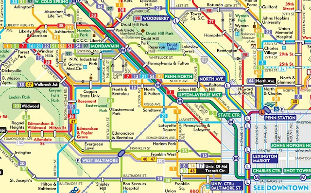
Photo by: detail, Maryland Transit Administration route
If only the MTA would follow these 10 rules of the road

Some ways to get Baltimore's mass transit system back on track.


Here's a little story I wrote that appeared in the Baltimore Brew on March 16, 2012 which sums up the basic principles of transit system structure that the MTA violates with impunity. It followed an impassioned account from a rider that appeared three days before, announcing she was giving up on the MTA.


Rude, sadistic bus drivers are but the tip of the symptomatic iceberg, when it comes to what’s ailing the Maryland Transit Administration. Actually, bus drivers are victimized by the same impossible transit system that riders have to deal with.

Here are 10 rules of transit planning which the MTA mostly violates with impunity, but if they would adhere to them, bus drivers could actually succeed in making the system work.

1 – The rail system should carry as much of the ridership load as possible. The empty seats on the rail system are the MTA’s biggest best untapped resource and potential economy of scale. In this regard, the Mondawmin Metro feeder bus hub is one of the few places where the system actually mostly works.

2 – All bus routes should be as short as possible. The longer a route, the more possibilities for things to go wrong and the farther buses can get behind schedule.
3 – A hierarchy of long and short routes should be established, allowing each to do what it can do best.
4 – For short routes, speed is less important and frequency is more important. High frequency makes reliability less of an issue because if a bus doesn’t come, another is scheduled to arrive soon. The city’s Charm City Circulator, which has an altogether more relaxed atmosphere than the MTA buses, can be a model. Redundancy with the Circulator, however, prevents more frequent service and needs to be eliminated.
5 – For long routes, speed is far more important, so routes should be located on faster roads with fewer stops. The MTA’s recent introduction of “Quick Bus” routes is a step in the right direction.
6 – Routes must be branded. Shorter routes can be branded for local neighborhood identity, creating a sense of local pride of ownership: “This is OUR bus route.” Riders will then demand courtesy from both drivers and each other, just like guests in our homes. Splitting the #1 line into branded South Baltimore and Sandtown lines makes a lot more sense than a temporary Fort McHenry Circulator.
7 – Fares should vary by trip or route length instead of “one fare fits all,” which defies all transportation marketing and economic sense. The electronic Charm Card creates opportunities for this which the MTA has so far ignored.
8 – There should be a comprehensive system of transit connection hubs, especially for the rail system, to replace the current system chaos with a coherent structure. An easy place to start is the parking lot next to the MTA’s Lexington Market Metro operations building on Eutaw Street, north of Saratoga Street.
9 – By far the most important rail system expansion priority must be to extend the Metro beyond Hopkins Hospital to a comprehensive transit hub comparable to the DC Metro/MARC New Carrollton Station. The official proposal to extend it to North Avenue/Broadway by 2035 would come far too late and virtually preclude any future extensions beyond that. A far cheaper extension to Edison/Monument could be done far sooner and facilitate future extensions to Bayview, Canton, White Marsh, Middle River and Dundalk.
10 – The proposed multi-billion-dollar Red Line is almost totally irrelevant to Rules 1-9. The continued existence of this plan merely demonstrates how the lame, directionless MTA has been manipulated by the developers, the Greater Baltimore Committee, City Hall, etc.

November 19, 2012

Fiscal Cliff

Y2K+13: The road off the "fiscal cliff" has already gone through Baltimore

Much has been said about the federal "fiscal cliff" of automatic tax hikes and budget cuts that are scheduled to take effect on December 31st, due to the ongoing national tax policy gridlock between liberals and conservatives. But Baltimore's economy fell off that cliff years ago, even with Baltimore mayors being free to follow any policies they've wanted. Baltimore has had no gridlock, except the old-fashioned kind on roads.

Baltimore's ongoing fiscal crisis is a preview of where the rest of the country is headed. The city already has high taxes on a dwindling tax base, supporting even higher spending that reflects the city and state's overwhelmingly lockstep liberal politics. But Baltimore has also followed the purportedly conservative course of dishing out tax breaks to the upper class who were supposed to lead to increased investment which has never materialized.

The solution should be a whole new tax policy that addresses inputs rather than outputs. What we get out of the economy is only as strong as what we put in.

Baltimore can teach the rest of the country a lesson

The stalemate is not between liberal and conservative goals. Individually and collectively, most of us have a liberal and a conservative side. Two years ago, President Obama kept the "Bush Era Tax Cuts" reviled by liberals when they were already set to expire on a mini-cliff. Conversely, "Romneycare" in Massachusetts haunted his conservative base throughout Romney's failed presidential campaign.

Maryland missed most of the onslaught of political sound bites broadcast nationally about this over the last two years, since the Democrats were obviously able to take our state for granted in their recent election victory. But basically, both sides were talking about us behind our back. The economic travails of the rest of the country have been supporting government spending allowing liberal Maryland to be the richest state in the union, even while Baltimore is still one of the nation's poorest cities.

So whatever happens at the Y2K+13 fiscal cliff will have more effect on Baltimore than the campaign volleys leading up to it. Democrats will still say tax the rich, which aims their fire directly at high income Maryland which supports poor Baltimore. Republicans will say cut federal spending, which also supports Baltimore. Automatic military cuts are also pending, which would also have an inordinate effect on Maryland. 

And beyond Baltimore and Maryland, military spending also has a global economic dimension. Middle East war cries affect the price of oil. Relations with China affect most everything else, particularly world trade which goes through Baltimore's port. The outcome of all this will probably be confusing or ambiguous, but it won't be pretty. Y2K+13 will no doubt have a greater impact than the Y2K computer crisis trumped up 12 or 13 years ago.

Baltimoreans also have arguments that we hope the rest of the country won't hear. Despite the city's virtually lockstep Democratic monopoly, Mayor Stephanie Rawlings-Blake continues a conservative mantra of lowering at least some taxes to attract investment, even if it's unclear for who, when and where. Of course, everyone wants someone else to pay and someone else's budget to be cut, not their own. But the laws of economics are not much in question. The power to tax is the power to destroy. When the country catches a cold, Baltimore gets pneumonia.

Clearly the tax system isn't working. Not enough private investment is trickling down through Baltimore's economy and the public money is either in the wrong places or isn't enough or both. It's all the same thing: misallocation of resources. The geographic money pipelines are clogged and/or misdirected, between Baltimore, its suburbs, the state of Maryland, the U.S. and the world.

Blame the game, not the playas

How do we get through Y2K+13 without just muddling through a battle of political wills? Places like Baltimore need to be played for their strengths instead of their weaknesses. Instead of playing for ever more federal aid for the "right" educational system or the "right" transit system or the "right" jobs stimulus projects, cities should simply be treated as places where people can live and work with a maximum of interaction and transportation efficiency. Yeah, that sounds vague...

But here's the point: Like the rest of the country, Baltimore will benefit the most not from picking winners and losers among the rich, middle class, poor, government agencies, private sector, military, civilians, or however one might want to slice the pie. We should be focused on how the game is played. Only then can cities like Baltimore play to their strengths.

There are actually still people who live in Baltimore because they want to, and because it serves their needs, rather than because they're stuck here or have found their niche to "game the system". It's not even something vague about potential. It's people who are really already here, and just want to make it work. Of course, it's also the thousands of people who would come to the city if they felt it would work, or have been repelled in the past. Cities work if their unique role in bringing concentrations of people face-to-face is exploited, which can't happen in the suburbs and hinterlands. To succeed, Baltimore needs only a small minority of the population, not as it was back in the heyday when Baltimore had nearly half the state's population.

To get off the fiscal cliff, we simply need to let those people flourish. It's not even just a matter of liberal intervention versus conservative laissez-faire. No matter how much the government intervenes, there will always be many people who are off of that radar screen.

Tax inputs, not outputs

Here is the clear way of how Baltimore can gain from the path down from the fiscal cliff: The nation needs a whole new approach to tax policy that addresses inputs rather than outputs. This has been proposed in many guises, such as energy taxes, consumption taxes, value-added taxes, gas taxes, sales taxes, user fees, carbon taxes, "freedom taxes" to reduce foreign energy blackmail, and cap'n trade systems to reduce global warming. It has been proposed as revenue-neutral to placate the anti-tax conservatives and as cash cows for the big government liberals.

What should be clear in this debate is that we're only going to balance our budget if we first grow the economy. It's dynamic, not simply arithmetic as has become trendy to say. There aren't enough rich people to carry us, even in Maryland, the nation's richest state. So we need to move from production (income) taxes which penalize output productivity to resource consumption taxes which encourage input productivity, quality and efficiency. People who want to benefit from less driving, less gas guzzling and more access to labor, social interaction and culture will find Baltimore. And they'll find all of Baltimore, not just the rich trendy waterfront.

Consumption taxes make a huge difference. When gas taxes go up, people find better ways of doing things and organizing their lives. Whereas when income taxes go up, people simply do less. Tolls on the new InterCounty Connector have radically curtailed traffic to the extent that questions why the multi-billion dollar road was built in the first place. That's money that did not need to be spent.

The stalemate between liberals and conservatives is just an excuse for an ongoing political fight. All Baltimore needs to do is hold itself up to the nation as a cautionary example as what will happen when we let ourselves fall off the fiscal cliff.

September 11, 2012

World's Widest Waterfall?

Inspired by 9/11:
A water feature inside the Highway to Nowhere

UPDATE 3/8/17: OK folks, Peter Tocco (bless his soul!) did do a photoshop of "The World's Widest Urban Waterfall" for me five year ago, but I never published it. So here it is, finally !!!!


For some stupid reason, I recall trying to convince Peter to do it up with a grand waterfront promenade (e.g. San Antonio's Riverwalk on steroids) and to make it "hydrologically correct" for the widely undulating elevation at the rim of the "Highway to Nowhere". But sheesh, why did I care? I never really decided where the Red Line should go either. I guess along Franklin Street (to the left of the above).

So add this to the "Low Line" proposal portfolio. And consider it an alternative to make Caves Valley's Metro West into a waterfront development and part of the Six-mile West Baltimore Greenway Loop.


It is September 11th. I just turned on the TV and it hit me. In my last post, I asserted that fixing Baltimore's "Highway to Nowhere" will require superior design, as well as creative planning. As great as the wanton destruction which has been wrought there, New York has a far larger and more profound wound to heal at 9/11 Memorial at the World Trade Center Ground Zero.

Baltimore needs the same kind of design vision, and I believe I mean that literally. A water feature that frames the destructive hole in the ground at the Highway to Nowhere ditch would be a compelling way to transform and unify the ditch, turning its blight into a focal point and preparing it for redevelopment. The sound of a waterfall thousands of feet wide would create the perfect "white noise" to aurally mask the traffic and create a soothing urban ambiance.

This photo taken inside the ditch during the half-year Highway to Nowhere closure shows a small piece of the south retaining wall, which could be converted into a waterfall. The up-close view across the grassy median and the eastbound roadway conveys how this scene does not need to be the oppressive environment that it currently feels like from a motorist's windshield or the urban wasteland above.

The world's widest waterfall at Franklin-Mulberry? It's possible. We simply need to unleash our collective creative juices instead of the heavy-handed construction machine that brought us The Highway to Nowhere in the first place, and is now trying to foist the Red Line upon us.

August 23, 2012

The LOW LINE

Introducing The LOW LINE:
Baltimore's answer to New York's High Line

Here's a Slide Show presenting graphics and photos that Peter Tocco and I have developed over the years for transforming the "Highway to Nowhere" into The LOW LINE.


Manhattan's High Line has taken the urban world by storm, and not just because it's an abandoned freight railroad transformed into a linear one-mile park in the sky. The High Line provides new insight into how unique urban environments can be beneficially fit into the city.

West Baltimore has just such an environment - the one-mile-plus "Highway to Nowhere" which has been wreaking havoc on the surrounding communities ever since it was first conceived way back in the 1960s.

The usual urban prescriptions have been tried and failed to turn these communities around: Rehabbed housing. Fighting crime. Social services. Brand new urban housing. Brand new suburban-style housing. 21st century biotech jobs. All of these have achieved only isolated successes.

Defenders of these programs say justifiably that isolated successes are a start, but it amounts to running just to stand still. The common aspect of all the solutions is that they attempt to celebrate normalcy - law-abiding guys with steady jobs who live in houses that are not boarded up.

The answer is not normalcy

But there's nothing normal about West Baltimore. To achieve normalcy there, you have to constantly shield yourself. Some do it with guns or gangs. The Heritage Crossing suburban-style enclave does it with earth berms. The biotech park does it with fumigated demolition and decked parking to minimize adverse community interactions. The city even proposed building a jogging/bike track encircling the upper rim of the "Highway to Nowhere" (applying for federal money of course) so people can get exercise while they're trying to survive their community's onslaught.

The big future multi-billion dollar transit project portends to make matters worse. The proposed Red Line would permanently embalm the "Highway to Nowhere" by using it to encase a new transit line - another solution that has been tried without success elsewhere in Baltimore. For many years, the city  even proposed building a cap over the "Highway to Nowhere" so we can just pretend it doesn't exist - a very expensive attempt at normalcy. New York went through the same process with the High Line. New York's previous effort was to simply demolish the old railroad structure and return to normalcy, which would have prevented the High Line from ever happening.

Physically, what West Baltimore needs is not normalcy. It needs a truly unique world-class environment to truly attract people, but with enough carefully designed access to its surroundings to plant the seeds of rejuvenation - to be apart from, yet a part of, the community.

This is what the High Line has done for Manhattan's West Chelsea and Hell's Kitchen communities, succeeding where the monster Javits Convention Center has not.

And this is what the LOW LINE can do for West Baltimore, connecting to Heritage Crossing, the MARC rail and Red Lines, the University of Maryland and downtown, but most importantly to itself and the adjacent forlorn communities.

Until now, the most successful Baltimore developments have clung to isolation and peninsulas and the waterfront. The LOW LINE finally offers a way to succeed by doing just the opposite.

July 13, 2012

Red Line to Harbor Point

Preparing for a Red Line that actually works
- Here are eight feasible non-rail (plus streetcars) projects
 which would prepare Baltimore for a functional transit line and vice-versa

Proposed Downtown Bus Tunnel could serve the Red Line when it's ready

With the recently announced major expansion of the Harbor Point development, the irrelevance of the MTA's multi-billion dollar decade-old Red Line plan is now assured. The Red Line is too expensive to build. It doesn't connect to the subway. And now we discover that it wouldn't even decently serve the new waterfront development growth it was contrived around. Instead, where every step beyond the station platform is critical, the MTA Red Line would be three to eight blocks away from Harbor Point. With the Inner Harbor reeling and Canton just a stable 1980s auto-oriented backdrop, Harbor Point's new expanded development plan puts as much development as far away as it can from its nearest Red Line station, making it just another plan for an expensive transit hole in the ground.

The Red Line was designed a decade ago to supposedly transform Baltimore. Now the Red Line has been left stalled. It was folly to expect Baltimore's redevelopment to keep waiting around for years and decades for a Red Line that will never be and won't help anyway.

So here are eight major projects which would actually prepare Baltimore to rebuild itself around a well-functioning transit system, and to incrementally and eventually build a Red Line that fits in and works, as opposed to a Red Line that could only be built in one multi-billion dollar swoop and would have to be forced into and under an alien landscape.


These eight projects would prepare the areas around the Red Line to be attractive and prime transit oriented areas, whether the Red Line was built or not. Then the Red Line could be built in small incremental manageable and affordable chunks. It would be built only where and when it is feasible, with little or no additional tunneling unless justified by real future events.

The alignment would be fairly close to the MTA's, except it would come much closer to the existing subway in the center of downtown, as well as to Harbor Point. Other inner city areas would be served much better and more suitably by streetcars, including the Inner Harbor and Canton. Bayview would no doubt be far better served by a heavy rail extension east of Hopkins Hospital.

It would no longer be a matter of putting faith in planners who insist that "if we built it, they will come", when the MTA's past track record has inspired no confidence whatsoever.


Red Liners know they have problems

About five years ago, one of the Red Line's primary authors said that if it was not built soon, it would be another generation before we got more rail transit. Well, Red Line construction is now even less in sight than it was then, so he appears to be right. "Another generation" would put the Red Line horizon at about 2030.

The price tag continues to move out of sight. Engineering difficulties recently required the proposed Red Line tunneling to be extended under Fremont Avenue in West Baltimore instead of rising to a surface alignment along MLK Boulevard. This will certainly drive up the unmanageable cost even more.There is no political will at the state or local level to do it. 

Here's the basic solution: Other major projects need to be identified which can be built along the Red Line corridor to improve the environment and facilitate future growth, whether the Red Line is eventually built or not.

Planners recognize the need for this strategy, but they have only done it in a very half-hearted way:

1 - The retaining wall at the west end of the "Highway to Nowhere" (Pulaski Street between Franklin and Mulberry) was finally demolished to make way for the Red Line. This was fraudulently hyped as the elimination of the entire highway, which was mere wishful thinking. The entire highway needs to go, but it needs to happen now, not taken as hostage to their Red Line. The next big event in the hapless highway's half-century history will be the Social Security Administration's impending abandonment of its massive Metro West complex. West Baltimore and Downtown need to be ready, even if the Red Line isn't (and never will be under the current plan).

The gorgeous Gwynns Falls looking toward Leak in Park from the Edmondson Avenue bridge, to be widened to accommodate the Red Line. The obsolete Hilton Parkway interchange is adjacent to the left, which should be eliminated to create community access to this beautiful scene, as should the huge Cooks Lane/I-70 stub interchange which also impinges on the park.

2 - The city plans to widen the Edmondson Avenue bridge over the Gwynns Falls and Hilton Parkway to make room for a future Red Line. In an ideal world, this cost would be borne by the MTA, but the city will instead pay it to keep the cost off the Red Line books.

3 - The city plans to build a "Boh-Donnell Connector" in Canton to help create the Red Line right-of-way. This is probably a worthy project in that it encourages through traffic to use the O'Donnell Street bridge over the railroad tracks, and then use Boston Street away from the community. But it is directly at odds with the plan to narrow much of Boston Street from two to one lane in each direction to squeeze in the Red Line. So what the "Boh-Donnell Connector" would really do is make Boston Street even more congested and encourage the planned Canton Crossing development to be even more oriented to I-95 and the suburbs than it would be otherwise.


Eight projects to pave the way

So here are eight recommended projects to truly pave the way for a Red Line - not the MTA's Red Line, mind you, but one that would truly prepare for Baltimore's comprehensive transit-oriented future. This far less expensive Red Line would traverse a brand new transit-oriented West Baltimore, would share a short new downtown bus-rail tunnel, would end up right at the front door of Harbor Point and Fells Point, and much more, all built when the city and transit system are ready for each other.

The following eight projects have benefits that greatly augment but far transcend the Red Line:

1 - Build a Downtown bus tunnel - This is what Seattle built to prepare for its eventual light rail line. In Baltimore it could be built under Saratoga Street starting near Greene, to Fayette Street near Gay, with short underground passages to the Charles Center and Lexington Market subway stations and escalators to the Howard Street light rail line. By being as short as possible, it could accommodate buses and facilitate transfers from many different directions, truly revolutionizing the MTA bus system. (See Brew story from Oct 2010)

Landlocked "Highway to Nowhere" median strip looking toward Downtown Social Security complex. Such wasted space !!!!!

2 - Tear up the "Highway to Nowhere" to facilitate new development - Replace it with a downsized highway and rail right-of-way to intimately orient transit to development and meet real-world traffic needs. Key anchor connections are the Social Security complex, Heritage Crossing, and the MARC station - all currently chronically isolated by highways. (See Brew story from April 2011)

Hilton Interchange Replacement Proposal - Yellow is new parkland with parking underneath, Green is new trails, Purple is consolidated Hilton Parkway thru underpass, Red is future Red Line on Edmondson Avenue

3 - Transform the obsolete Edmondson Avenue/Hilton Parkway interchange - (not just widen the overpass)  - to create new Gwynns Falls parkland integrated with Red Line needs, with hidden parking embedded into the topography. This would not only be a tremendous asset in connecting the community to its surrounding parkland, but it would also make this point a suitable Red Line terminus to enable the disruptive Edmondson Avenue section to the west to be built later or even cancelled. (See Brew story from March 2009)

Proposed Red Line thru Harbor Point, from Fayette Street (upper left) to Central Avenue (center) to edge of Fells Point (lower right). Proposed streetcar tracks in yellow.

4 - Design Harbor Point to accommodate a surface Red Line terminus right on the site - A minor modification to the recently announced Harbor Point site plan would enable the massive development to be truly oriented to a Red Line on the streets just outside its front door instead of buried in isolation under Fleet Street three to six blocks away. The Red Line terminus would then be adjacent to the intersection of Thames and Caroline Street, making it a great gateway to Fells Point. (See blog article from February 2012)

Central Avenue looking south from Pratt toward Harbor East and Harbor Point

5 - Rebuild a civilized transit-oriented Central Avenue - Central is currently the prime but ugly formerly industrial "no man's land" between Harbor East, Fells Point, Little Italy, Jonestown, Old Town, Washington Hill and Hopkins Hospital. Its crumbling underground stormwater tunnel is largely to blame. Rebuilding that would create a prime opportunity to prepare the street for a future surface Red Line instead of tearing up Lombard, Fleet, and Boston Streets for a far more expensive, disruptive and isolated Red Line tunnel.

6 - Build a streetcar system - The Red Line does a very bad job of attempting to simultaneously emulate both a streetcar system and regional rail system. Building on the excellent Charles Street Trolley study, Eastern, Fleet and Pratt Streets (but not Lombard) would be excellent candidates for a streetcar system that would be conveniently optimized to serve shorter trips. The MTA's Red Line would use the same kind of slow, diminutive low capacity streetcar-style vehicles which are not appropriate for the extensive inconvenient user-unfriendly tunneling that would make it as expensive as many heavy rail lines. (See blog article from May 2007)

7 - Reinvent the Inner Harbor again - A streetcar system would be a wonderful urban design theme for redesigning and redefining the oppressively wide Pratt and Light Streets in the Inner Harbor as livable environment. A few years ago, there was momentum to actually reinvent these streets, until the street-oriented retail pipe dream ended with the closure of Best Buy and Filenes's, the weird new Harborplace Ripley "Odditorium", the cheap new half-fast bike sidewalks, and of course, the Grand Prix making the streets safe for 180 mph race cars. 

8 - Expand Leakin Park into Baltimore County - The MTA's Red Line would pave over even more of the suburban countryside that is already occupied by the grossly excessive stub of Interstate 70, stunted at the edge of Leakin Park. This entire highway needs to be replaced by a modest narrow parkway, which would create much new parkland. A Red Line should be designed that would tuck unobtrusively into the resultant greenery of an expanded Leakin Park, hopefully in a way that would make the expensive disruptive tunnel under Cooks Lane unnecessary. (See Brew story from October 2011)

After all of the above, the MTA could still build the Red Line in accordance with the 2002 plan, but the folly of continuing to attempt to do that will become increasingly obvious, even to them.

May 9, 2012

Druid Hill Park Roundabout

Roundabouts that actually solve problems

Hopefully, the city is taking roundabouts seriously as a specific tool in solving real problems of traffic and its impact on the environment. The city's proposal to restore the former roundabout at Park Circle, using modern techniques and standards, is a good sign. The jumble of channelized road connections installed there at Reisterstown and Park Heights about fifty years ago to replace the roundabout never worked.

The labyrinthine concrete mess at the other corner of Druid Hill Park - the intersection of Fulton, McCulloh, Druid Hill, Druid Park Lake Drive and Auchentoroly Terrace - has never worked either. I mentioned that in my Baltimore Brew article of November 19, 2010. Now I've drawn up an example of how it might be done, as shown here.


This should be part of a larger step-by-step effort to undo the long-term damage highways have inflicted to the relationship between the neighborhoods and the park. It's about reinvention. It's not just a matter of trying to carve out street space for bikes or anyone else, such as the "complete streets" program which was rejected by the nearby community on Monroe Street.

Hopefully, the city will not just be using roundabouts to make a showy "statement", such as their half-baked plan for Light Street and Key Highway in the Inner Harbor.

March 8, 2012

Trolley Phase One

Charles St Trolley Fixes Fractured Downtown

A connector (shown in orange) should be built so that the proposed Charles Street Trolley (in yellow) can return southbound to the Inner Harbor via the existing Howard Street light rail line (in blue). A future trolley connector (in green) can extend the system to Harbor East and Fells Point, among other places.

The proposed Charles Street trolley project is unfortunately perceived from some viewpoints as just another expensive project promoted by one downtown faction in opposition to all others, each with their own goals and pet projects.

The most recent example of this downtown infighting was the battle over the new Exelon office building, waged by Harbor East versus the Inner Harbor. Similarly, traditional downtown interests led by Peter Angelos have filed a lawsuit against the massive State Center project, which they see as an economic threat. The battle for West Side interests is to demand attention on the stalled Howard Street Superblock development. To others, the battle is against the perceived Disneyfication of the Inner Harbor, typified recently by the Grand Prix which is seen (among other accusations) as an opportunistic threat which allows downtown to be dominated by a high speed tourist spectacle instead of creating a livable environment for residential growth. The proposed mega-convention center arena is also part of this threat.

Battle of Transit Systems

In this political landscape, the Charles Street trolley project has run headlong into the big political push for the rail transit Red Line. The city government and Maryland Transit Administration have been tepid at best in their support for the trolley because they feel they must summon all their political capital in their uphill pursuit of the multi-billion dollar Red Line. The Red Line alliance is particularly convoluted because it also includes another two billion dollars plus for the Purple Line in Montgomery/PG Counties, as well as support from big highway interests through the common ground push for a big gas/sales tax increase and a firewall to prevent spending it on education or other lip service priorities. Big as the state's proposed gas tax increase is (6% more or roughly double the current rate), it is barely a blip of the many billions all its champions want to spend. Meanwhile, amid this alliance, the city has gone into the transit business against the MTA with their severely redundant Charm City Circulator system, further fracturing the city's transit system.

Of course, most of the parties in all this will claim that they are actually working together, or at least that their alliances overlap one or another. Most of the battles are unspoken or under the radar.

Politics Versus Actual Long-Range Planning

Lost in all this is any real focus on the city's long range. How can all this fit together? The short answer is that it does not. Harbor East is now expanding out onto the Harbor Point peninsula, where it has virtually no subsequent place to go except to keep sapping the strength of the traditional downtown. The Inner Harbor is indeed becoming a Disneyfied sideshow. The West Side Howard Street corridor is nearly dead. Charles Street is keeping its head above water, but while the Charm City Circulator is seen as their liberation from the dreaded MTA, it does not bode well for the transit system as a whole. The MTA itself is a bigger money pit than ever. And the proposed Red Line would not even connect to Baltimore's existing subway.

But in all this, the Charles Street trolley project could actually be repositioned to become the glue to bring all the competing downtown factions together. Unlike the rest of the competing monolithic dinosaur-like projects, the Charles Street trolley could actually be instilled with the flexibility to bring Charles Street, State Center, the West Side, the Inner Harbor and Harbor East together instead of creating collateral friction which is blowing them apart.

The most obvious asset of the trolley project is its visual sizzle. Nearly everyone loves the idea of trolleys - spacious accommodating vehicles lumbering through an appropriately scaled streetscape, with the warm glow of nostalgia for a more civilized time long ago. Baltimore's surface light rail remains photogenic even as it fails miserably, and artist conceptions of the proposed Red Line try to make it look as trolley-like as possible, even though its massive disruptions, regional pretensions and giant price-tag are the diametric opposite.

Yes, buses can functionally do almost anything trolleys can do, and the city's Circulator has indeed appeared to live up to its promise even while the MTA remains clueless about how to attract people to buses. And at a cost in the hundreds of millions for a modest four mile run, the Charles Street trolley is not exactly chump change.

So what we need to do is sharpen the focus of the Charles Street trolley project, to satisfy the objectives which take advantage of its inherent strengths:

1 - Minimize its cost
2 - Maximize its positive influence
3 - Make it the center of an actual coherent consistent set of planning objectives for all of "greater downtown".
4 - Make it a project that all of downtown's fractured factions can believe in and support.

A Trolley Plan Everyone Can Love

Here is a plan that meets all these objectives:

1 - Build the "core" of the Charles Street trolley northbound-only from the Inner Harbor to Penn Station/Station North - only one track, one street, and about half the length of the original plan.
2 - Connect the trolley line to the existing Penn Station light rail spur to enable southbound return travel along the Howard Street light rail line.
3 -  Build a short trolley connection along Pratt and Light Streets from Howard Street to the Inner Harbor.
Existing light rail going under Maryland Avenue bridge. This track would be realigned up to Charles Street to connect to the proposed trolley line. (The new Fitzgerald complex adjacent to the University of Baltimore/MICA light rail station is in the background.)

This would be the first phase of a trolley system that would eventually go to Charles Village. It would also be poised for extensions to many other places such as Harbor East, Fells Point, South Baltimore, Northwood, Carroll Park and wherever (see my many blog articles).

This would give the Charles Street interests the core of what they want, and the momentum to get the rest.

It would also give Howard Street a shot of instant visibility and recognition. Current perceptions are that Howard Street is in another universe from the rest of downtown, but it is actually very close to some of Mount Vernon's major attractions, including the Historical Society, Walter's Art Museum and Antique Row (which would need a new station stop near Read Street).

This would also give added impetus to the State Center project along Howard Street, which is supposed to be based on "transit oriented development", which everyone agrees is good, but has instead become notorious for its questionable financial schemes. Perhaps if State Center had attractive transit access from the rest of downtown and the waterfront, it wouldn't need so much additional financial legerdemain.

Incorporate the Trolley into the Inner Harbor's Reinvention

Perhaps most importantly, building trolley tracks along Pratt and Light Streets in the Inner Harbor would renew the city's commitment to redesign these horribly auto-dominated streets in a civilized manner. This was the city's strategy several years ago, before the Grand Prix came long and pushed the city to quickly repave the streets to accommodate 180 mph race cars, to the detriment of the long term goal of a livable downtown neighborhood.


Early conception of the trolley line between McKeldin Square (left) and the Inner Harbor on existing Calvert Street. A much better idea is to make the trolleys the centerpiece in a totally new street design for the Inner Harbor.

Efficiently accommodating a trolley line on Pratt and Light Streets is a tricky proposition, given the high traffic volumes. Accommodating bikes has also proven difficult, especially for low skill riders, which the city appears to have failed to do in both the current and proposed designs. But it certainly can be done. The city previously earmarked $100 million for the total reconstruction of downtown Pratt Street and its connection to Light Street. Accommodating the trolley line in this plan would get the most bang for the bucks.

Ever since Harbor East beat the Inner Harbor in the Exelon sweepstakes, there has been renewed lip-service to making the Inner Harbor and Downtown into a more "livable" community, but this has flown in the face of the Grand Prix as well as the mega-convention arena plan, and tacky Inner Harbor plans such as the  Ripley's Believe-It-or-Not Odditorium.

Just as a short trolley link between the Inner Harbor and Howard Street would force the various forces to think on the same page, redesigning these streets for livability would also align the various priorities.

A trolley system is also the perfect "vehicle" for creating a strong unified motif between the various parts of Downtown, the Inner Harbor and Harbor East, and emphasizing short-distance travel between them. The proposed Red Line is totally ill-suited to fulfill these objectives, since it would be buried underground with inconveniently burrowed-away station locations, most suited for regional travel such as to the Edmondson Avenue/Social Security corridor rather than short jaunts around downtown.

Such a trolley system would also work better than the Red Line in concert with the existing regional light and heavy rail lines, creating a logical hierarchical system, with far easier connections between them.

All in all, building only a modest piece of the proposed Charles Street trolley as a first phase would not only make it far more affordable, but it would also open up all the opportunities to make the system work for all of the fractured downtown interests which go far beyond Charles Street.

February 28, 2012

Stacy Keibler at Penn Station

Penn Station: A new more popular Man-Woman Statue
After her recent universally acclaimed Oscar performance as George Clooney's arm candy, Stacy Keibler is now undoubtedly the world's most famous Baltimorean. So what could be a better follow up role than replacement of the reviled Man-Woman Statue in front of Penn Station?

February 9, 2012

A Town Square for North Avenue

The North Avenue space shown in green could be transformed into an elongated Town Square - looking west from the Centre Theatre (right) toward Charles Street and Maryland Avenue.

Now that the potentially dazzlingly moderne Centre Theatre on North Avenue near Charles Street has recently been announced for renovation, it's time to unify North Avenue's streetscapes into a Town Square, modelled after Canton's O'Donnell Square. Right now, North Avenue brutally slices through the area, creating a barrier which has served to spread blight over its entire length from east to west Baltimore. But as the widest section of Baltimore's widest east-west thoroughfare, it offers the greatest potential for reinvention as a central focal point.

The Station North neighborhood is also oriented far more to the north and south than to east and west. Thus the linkage to Penn Station, University of Baltimore, MICA, Downtown, Charles Village and Hopkins University would be enhanced by reducing the east-west expanse of North Avenue.

Widening and redesigning the median

The most offending element is the median strip, which makes North Avenue's extravagant width work against it, causing as much congestion as it relieves. The overall curb-to-curb street width of up to 100 feet or more requires long pedestrian "Walk" signal phases, which in turn requires long cycle lengths, which in turn increases vehicle stacking and delays.

The current North Avenue median is a wasted space occupied by a dense thicket of evergreen bushes.

North Avenue needs to be narrowed for the sake of both people and traffic, as well as their mutual interaction. The easiest, quickest and least expensive way to do this would be to leave the outer curbs alone, with their extensive and drain inlets, and focus on adjusting the median.

Baltimore has seen various attempts to make urban medians into people places. At McKeldin Square (Light Street) and Preston Gardens (St. Paul Street), this has been done in wide and extravagant but failed fashions. Now both are scheduled to be rebuilt yet again to atone for past urban design mistakes. A much more modest rebuild was done to the Broadway median in Upper Fells Point. At only about 16 to 32 feet in width (with or without the parking lanes), the Broadway median was still able to be transformed into an inviting linear pedestrian area.

O'Donnell Street in Canton is the best model for a median that looks and functions like a people place instead of a median. This is what North Avenue should aspire to, albeit in a somewhat narrower and longer configuration.

Creating a median that does not feel like a median

But the city's most successful urban median is O'Donnell Square in Canton, because it does not look or feel like a median at all. O'Donnell Street looks and operates like two separate streets, one eastbound and one westbound, with an inviting park in between. Putting the park between two such traffic arteries makes it as prominently public as possible. There is no possibility of the kind of public-private ambiguity seen elsewhere that can make parks into less defensible spaces. (The very public nature of McKeldin Square was why it worked for Occupy Baltimore even though it has largely failed as a park.) However, that's easier to do it with that median in Canton (80 feet width) than it would be at North Avenue, which can probably only be widened to a maximum of 40 to 50 feet.

Making east-west North Avenue feel more like two narrow streets than one wide one would be consistent with the corridor's overwhelming north-south orientation, and overcome the "barrier" effect. Hopefully, the resulting effect would function in a manner somewhere between Broadway and O'Donnell Street. But another problem is that North Avenue carries far more traffic than either of those other streets.

Having traffic coexist with a wider and more people-oriented median would require overcoming a combination of operational and psychological factors. Psychologically, it is important that pedestrians would perceive that the North Avenue median is not a mere "safety island" between the eastbound and westbound traffic flows. Pedestrians always want to cross such wide streets in one "Walk" signal phase, and when they can't, they feel very uncomfortable stranded in the middle. That's one reason why North Avenue, MLK Boulevard, President Street, Conway Street and other wide streets are such pedestrian failures.


Making the signal timing work

It's also why people tend to campaign for longer and longer "Walk" signal times, even though that also requires increasing the "Don't Walk" for one or more other crossings as well, resulting in pressure to increase overall signal cycle times. On the contrary, the best traffic/pedestrian environment is achieved when signal cycle lengths are minimized. Pedestrians should only have to wait through a brief "Don't Walk" and as soon as "Walk" comes up, they just walk, without worrying how long it will take. Countdown pedestrian signals are invaluable in reducing the anxiety, but motorists also need to be conditioned that once pedestrians are in a crosswalk, it belongs to them.

To make this work, pedestrians need to feel comfortable crossing only half of North Avenue at a time, and feel naturally at home when they get to the Town Square park in the median. The park must feel inviting and not be perceived as just an island.

Reducing the signal cycle lengths are also important to get traffic to cooperate. With fewer cars per signal cycle, the goal should be to eliminate the left turn lanes and green turn arrows, and have cars stay in the median space while waiting to turn left across opposing traffic. If this does not work, left turns would need to be prohibited during peak hours. It is also important to improve timing coordination between signals at adjacent intersections. North Avenue should thus be reducible to two lanes in each direction, which is the same as most of the rest of North Avenue throughout east and west Baltimore. It may also help to designate a double left turn lane from westbound North Avenue to southbound St. Paul Street, just east of the Town Square, to divert traffic and provide additional capacity just prior to the widened Town Square Park median.

Overview of the space that a North Avenue Town Square could occupy between Maryland Avenue (upper left), Charles Street (center) and St. Paul Street (right).

Putting it all together

By doing all this, the North Avenue median can hopefully be widened to around 50 feet between Maryland Avenue and Charles Street and about 38 feet in width between Charles and St. Paul Street. This should be wide enough to create a successful North Avenue Town Square Park. However, this will pose a challenge for the urban designers as well as for traffic planners and engineers, since it will still be far less than the 80 feet width in Canton's O'Donnell Square Park.

But North Avenue thirsts for such a highly visible and truly public urban square far more than does Canton, which is blessed with the waterfront promenade and several other major open spaces mere blocks away, including Patterson Park.

The benefits of a North Avenue Town Square are sufficiently great that it would be well worth taking maximum advantage of the opportunities available.

February 6, 2012

A Red Line plan to Exelon and Harbor Point
The Red Line's east terminus could be shifted to the heart of Harbor Point (lower right), at Exelon near Fells Point. Proposed streetcar lines are shown in yellow, existing subway in green and light rail in blue.

The recent decision to build the massive Exelon office complex in Harbor Point confirms downtown's strong eastward shift, and has rendered MTA's rail transit planning largely obsolete. Even more, it is a sign of the end of downtown as the central hub of a larger region. Major companies are no longer choosing downtown because of regional geographic advantages. While it is as necessary as ever for downtown to be the connecting hub for transit lines, suburb-to-downtown commutes represent a increasingly insignificant share of all trips.

In 2009, I devised a plan which anticipates and reflects for this. It would cost far less and do much more than the MTA's multi-billion dollar Red Line plan.

The MTA's Red Line plan is increasingly irrelevant

The elusive and fickle focus of downtown activity has been and still is a major problem for transit planners, and is probably the number one factor in Baltimore's failure to grow around its transit system. Back in the 1960s and 1970s, the Howard/Lexington retail district was downtown's most active place, and was an extremely important station location in the proposed rail transit system. But by the time the first rail leg was completed in the mid '80s, the retail district was already in serious decline. The MTA then doubled-down on its bet with the light rail system focused on adjacent Howard Street as well, which only made the decline even more precipitous.

The Red Line, originally devised around 2001, scrupulously attempted to avoid this problem by locating in the hottest areas along the Inner Harbor, Fells Point and Canton. But now even those areas are getting far less attention, with the Inner Harbor spurned by Exelon, and Fells Point and Canton in a state of stable low-growth maturity, with Canton Crossing being built in a very auto-dominated manner.

Transit-oriented development has been a consistently auspicious flop in Baltimore. It actually appears that developers go out of their way to avoid transit. And Exelon's recent decision to build at Harbor Point, on an isolated peninsula that is about as far away from the transit system as they could get, is perhaps the best example yet.

The new Morgan Stanley building near the proposed Exelon building at Harbor Point, auto-oriented and isolated from the rest of downtown.

But to some extent, it's not just that developers are just avoiding transit, but that they are avoiding the whole traditional concept of downtown in the region. The suburbs are increasingly self-sufficient and auto-dominant, not tied to the classic suburb to downtown commute. Both the city and the suburbs are increasingly tied into a much larger super-region which revolves far more around Washington DC and even the northeast corridor of the U.S. as a whole.

As with Morgan Stanley and Legg Mason, Exelon saw no significant advantage to being in the hub of downtown, just as UnderArmour similarly decided in its recent decision to locate its corporate campus headquarters in Locust Point, again about as far from transit as possible.

Increasingly, downtown is just an environment and a lifestyle, based on the unique attributes of the waterfront, historic architecture and high density interaction, but not the hub of anything.

Regional access is still important, but mostly just to create the linkages of a true transit system, not as an end hub in itself. It is important that the rail transit system have a true backbone, to create a logical organizational structure. Downtown is the place where transit riders transfer between the system's bus and rail lines. The system's rail "trunk" must be as fast and efficient as possible. The Mondawmin Metro Station is the system's one very successful example of this, where myriad bus lines converge with easy transfers to the much faster and more efficient Metro. But the rest of the system fails to compliment this.

The MTA's proposed Red Line would only make matters worse, not even connecting to the Metro except through a two block long pedestrian tunnel. It's also too slow for such a long line (over 14 miles) as it meanders between far east and west Baltimore.

The fact that the rail system does not even serve Harbor Point as the new downtown growth center further adds to the problems. And the isolation of Harbor Point emphasizes its lack of spin-off development opportunities. Harbor Point would be about a third of a mile from the closest Red Line station, and that is contingent upon building a controversial Central Avenue bridge which would cut off the Living Classrooms campus from the harbor. If the rail system itself is not a catalyst for redevelopment, as demonstrated on Howard Street, and isolated Harbor Point is not either, one of rail transit's biggest selling points of being an agent for growth vanishes.

The Red Line tries to serve the system and to enhance development opportunities, and ends up doing a very poor job of both.

Running the Red Line straight into Harbor Point instead

The solution is a rail transit plan that puts connectivity first, then relies on a system hierarchy from fast heavy rail to medium speed light rail to local streetcars to create and support development opportunities, and acknowledges that what was once known as downtown is now too dispersed to serve in any other way.

In such a plan, the Red Line would be located in a very short tunnel under Fayette Street, where it would be close enough to the Charles Center Metro station and Howard/Lexington retail district and light rail line for optimum connections. The very short tunnel would extend only from about MLK Boulevard to Gay Street (near City Hall), greatly reducing its cost and increasing its flexibility. It could even be built to accommodate buses as well, like the Seattle system, as well as an extension of the existing central light rail line from Penn Station through the Jones Falls corridor.

East of the tunnel, the Red Line would turn into Central Avenue, and proceed to a terminus in the heart of Harbor Point, immediately adjacent to Exelon, the recently completed Morgan Stanley building and the west edge of Fells Point near Thames Street.

Sojourner-Douglass college is one of a few signs of life along Central Avenue near Fayette Street, looking south toward Harbor East and Harbor Point along a potential Red Line alignment.

A whole new transit-oriented corridor would open up along Central Avenue between Sojourner-Douglass College and Harbor Point. The proposed bridge into Harbor Point could be designed as a high arch for transit   vehicles rather than cars, which would create a distinctive attraction and still let Living Classrooms boats go underneath. Pedestrians could also be accommodated secondarily.

The portion of the Red Line from the Inner Harbor to Canton, Highlandtown and Bayview would then be built as a streetcar line, linked to the proposed Charles Street Trolley system, as well as to the light and heavy rail lines, with the alignments optimized for the increasingly important localized rather than longer regional trips. As such, the streetcars would far more conveniently traverse Pratt Street and Piers 5 and 6 directly through the Inner Harbor rather than buried under auto-dominated Lombard Street.

All of this would cost far less than the $2.2 billion Red Line, because of the drastic reduction of counterproductive tunneling, and serve far more. And perhaps even more importantly, the system could far more easily and feasibly be built in affordable stages rather than all at once.

Such a system would reflect what most people, including Exelon and their local Constellation Energy division, already realize - That downtown is increasingly an environment and a lifestyle rather than the traditional geographic entity, which can only capitalize on transit which is integrated conveniently and attractively into the landscape, rather than built into expensive, outmoded and isolated tunnels such as with the MTA's proposed Red Line.

January 28, 2012

Exelon in Westport

Give it up, Downtown Partnership -
Put Exelon in Westport
Patrick Turner's proposed Westport development on the Middle Branch, near the Baltimore-Washington Parkway

It's a municipal wet dream. A Fortune 200 company plans to build a major new office building, an investment of hundreds of millions, and they're only considering one city - Baltimore.


So Kirby Fowler, President of the Downtown Partnership, writes in the Baltimore Sun that the downtown business interests he represents do not want Exelon to build a new building, because there is already a glut of unwanted office space. And failing that, they want only downtown sites to be considered, even though he admits that locating there would require massive tax subsidies as an inducement that Exelon is not even demanding.

January 10, 2012

Key Highway / Light Street Update

An intersection design that actually works -
Without the drama
The intersection of Key Highway and Light Street is totally inappropriate for a roundabout. Here's a simple design solution that actually works. Essentially, the two existing islands on Key Highway and Light Street would simply be enlarged to tighten up the intersection of northbound Light Street and the southbound left turn movement that crosses over it. This very tight intersection with minimum length pedestrian crosswalks would be controlled by a simple two-phase traffic signal. Pedestrians would cross Key Highway while Light Street through traffic moves, and would cross Light Street while Key Highway traffic moves - so simple even a BC-DOT employee could do it.

A third median island would then be constructed to totally remove southbound Light Street from the intersection. This island would start at Montgomery Street and extend as far north as desired. Essentially southbound Light Street would function as a quiet single-lane local service road with parking and any other appropriate desired traffic calming measures such as speed humps and "Stop for Pedestrians" pylons. It would also be possible to extend the southbound Light Street island separating "arterial" traffic destined for Key Highway and "local " traffic destined for Federal Hill as far north as Conway Street. While this would be an excellent way of minimizing the heavy traffic exposure on the adjacent land uses (Christ Church Apartments, Harbor Court Condos/Hotel), it would tend to make this seem like a permanent solution.

This design should be much cheaper than a roundabout. The railroad track wouldn't even need to be removed, unless the city wanted to. It would probably be preferable to keep this as cheap as possible, in keeping with the idea that it would only be temporary until the city comes to its senses and decides to create a more permanent solution with a narrower Light Street along the entire Inner Harbor.

Proposed intersection design, with a new median island starting at the Montgomery Street intersection (left/south end) to totally separate southbound Light Street through traffic from the Key Highway intersection. This median could be extended as far north (right) as desired. The two existing islands (center) would also be enlarged, with a new "bump out" (center left) to tighten up the remaining intersection as much as possible. The Science Center is at the lower right.

January 6, 2012

Roundabout at Key Highway / Light Street

An Inner Harbor roundabout for all the wrong reasons
The real problem is that Light Street is about twice as wide as it should be. A roundabout at the end of this stretch of the Inner Harbor in front of the Science Center (upper left) would only add to its problems.


The only good thing that can be said about the city's latest proposal for a roundabout at the intersection of Key Highway and Light Street is that there is plenty of space for it. But it would be just another Inner Harbor doo-dad that ignores actual traffic conditions and long-term needs.