The vacant desolate Metro West office complex and the beautiful but isolated Heritage Crossing neighborhood next door need each other, as does the rest of northwest Baltimore beyond.
Former City Housing Director Dan Henson, the man in charge when Heritage Crossing was being developed in the 1990s, wanted the new neighborhood extended southward to take over the land now squandered on the "Highway to Nowhere". The time has finally come to achieve Henson's vision, now that planning has begun for redevelopment of the huge Metro West complex after its abandonment by the Social Security Administration.
The elements for success are there. One can see the Metro West tower majestically in the distance from Heritage Crossing's lovely Perkins Park and imagine a large, connected and prosperous community, just as Dan Henson did in the 1990s.
But the contrasting reality is jarring. Beautiful Heritage Crossing stands adjacent to vacant hulks of abandoned rowhouses. Homeless people have been chased by the city from one campsite to another under and around the "Highway to Nowhere".
Economically, the biggest danger sign is that Caves Valley Partners was able to buy the million-plus square foot six-square block Metro West complex from the federal government for a mere $7.1 million. Contrast that with the recent Harbor East real estate deal that valued the single Legg Mason building at nearly $300 million for about half the square footage.
Events at Metro West have proceeded rather predictably from the account just over a year ago in my blog.
The first step in Metro West's redevelopment process has been a very bad one. The developer's recent plan plops a huge 2200 car parking garage down on a large vacant parcel (shown above) with no clue as to how it relates to anything, thus violating just about every principle of good planning. This parking garage plan was quickly rejected by the city's Urban Design and Architectural Review Panel.
The fundamental problem with the monster Metro West parking garage proposal isn't simply how big, ugly and imposing it is. The problem is that it needs to fit properly into a comprehensive plan for the entire six square block site, and it just can't.
The parking garage site simply eludes all possibilities for good planning. It sit on a "superblock" that is far too big, bounded by Saratoga, Greene and Mulberry Streets and Martin Luther King Boulevard, equivalent in size to three square blocks, which creates a fortress mentality. This means it inevitably creates dead spaces, or "border vacuums" as Jane Jacobs called them in her seminal book, "Death and Life of Great American Cities".
The small ground level retail space shown on the Saratoga street frontage is a very lame attempt to address this problem. The chances of any kind of healthy retail being attracted here is somewhere between slim and none.
But all the frontages surrounding this garage site would be similarly desolate. To the south, the other side of Saratoga Street is the derriere end of the University of Maryland campus. MLK Boulevard to the west is just a huge congested traffic artery. To the east is the rear "service entrance" for the existing Metro West complex and to the north is the "Highway to Nowhere" as it slices through the site - possibly the next location for the nomadic homeless camp as the city chases it away from site after site.
Planners can deal with perhaps one, two or maybe even three dead sides to a development site, but not all four. Here they decided to pretend that the Saratoga Street frontage was somehow viable, but it really isn't.
The problems created by the proposed parking garage cannot be solved in isolation, but can be solved with a wide-ranging step-by-step plan:
1. Create an attractive human-scale street spine through the Metro West site - Fortunately, this is possible to do. Pine Street to the south through the University of Maryland campus has the potential to be such a street. Myrtle Avenue to the north through Heritage Crossing, flanking beautiful Perkins Park, is already such a street. They simply need to be connected, which is what the meandering (a la Olmsted) yellow line through the graphic above indicates. This street could be designed to carry no through traffic, since it could have no median opening at its crossing of MLK Boulevard adjacent to Heritage Crossing. It would approximate the southern extension of Myrtle Avenue which existed from the nineteenth century until MLK Boulevard was built in the late 1970s.
2. Distribute the new parking with new development - Instead of building a single dominant 2200 space parking structure as recently proposed, the parking should be spread to at least two major new structures with "wrap around" office space or other new development along its outer edges. The new Myrtle-Pine spine would actually facilitate this by created an attractive local street frontage for both development sites on either side of Mulberry Street, while not seriously reducing the footprint size of the buildings.
The developer's proposed retail frontage along Saratoga Street would then have a context to be able to function properly, and more retail frontage could be added along the new spine. Saratoga is also proposed as a street to locate a revised west-only light rail Red Line, and this would be an ideal place to put a station, although we know from the Howard Street experience that this alone is not sufficient for revitalization. The retail uses would also compliment the free-standing suburban-style Rite Aid drug store just across MLK Boulevard, which was recently renovated after suffering major damage in the 2015 riots. In the long run, this Rite Aid could be replaced by higher density development as the depressed property values hopefully increase to what they should be.
3. Tear down the northern overpass of the "Highway to Nowhere" and consolidate traffic on the southern half - We know that the "Highway to Nowhere" can be closed with little adverse effect to traffic, as has already been done numerous times for various peripheral construction projects. But while the "Highway to Nowhere" is extremely detrimental to its adjacent community environments, it is probably best to retain one of its two overpasses over MLK Boulevard so that all its traffic does not need to use the intersections with the similarly heavy MLK traffic. Consolidating traffic on the southern overpass would keep it as far as possible away from Heritage Crossing, to facilitate its expansion. This traffic diversion should also allow Franklin Street to be shifted away from Heritage Crossing as well, and perhaps even allow Mulberry Street to be closed just east of MLK to serve only as part of the Pine Street local circulation for Metro West.
In any event, demolishing just one overpass would eliminate the worst aspect of the "Highway to Nowhere", which is its isolated dead space between the eastbound and westbound highways. The single remaining overpass would actually be quite open and airy, and very compatible with an attractive development plan for the adjacent parcels. MLK Boulevard will remain a formidable barrier and the single overpass, open to both people and vehicles, will bridge it.
4. Restore and reopen Fremont Avenue between Franklin and Mulberry Streets through the "Highway to Nowhere" corridor - Old Fremont Avenue is the point where the highway makes its transition from being down in a ditch to the west, to being up on overpasses to the east. It is also the point where pedestrians now dangerously walk across the formerly Interstate highway. By rebuilding and reconnecting Fremont Avenue with traffic signals, the communities would become more unified and the crossings would be safer and more pedestrian-friendly.
A newly reconnected Fremont Avenue would also make an ideal location for an additional station in a revised Red Line plan, because it would not be down in the "ditch" like the planned Harlem Park station to the west. The community of Fremont homeowners just to the south sued the MTA to stop the Red Line tunnel under Fremont from the cancelled Red Line plan.
5. Get rid of the "Highway to Nowhere" in up to six phases to accommodate new development - The city doesn't need to get rid of the "Highway to Nowhere" all at once. The first two steps were already taken at the west end of the highway when its retaining wall was demolished and Payson Street was reconnected through the corridor. These projects were time consuming and lauded as a big deal, but they were really just preliminary. The third step would be to build the connecting roads that will enable the north (westbound) bridge over MLK Boulevard to be knocked down and allow both directions of traffic to be consolidated on the south overpass. One lane in each direction will be sufficient on this bridge and even leave room for new sidewalks and bike lanes, since this will no longer be an expressway.
The fourth and fifth steps will be to complete the new local north-south streets: Fremont Avenue across the corridor and Pine Street underneath the overpass to Myrtle Avenue in Heritage Crossing. The sixth and final step would be to close the remainder of the "Highway to Nowhere" in the mile-long ditch between Fremont and Payson to create a development and greenway corridor, as depicted in the rendering below.
Right now, Metro West's developer appears to be acting under the assumption that since it paid a bargain basement price for the property, this will be a bargain basement project. Not only did they recently submit a bare-bones generic garage plan, they have also advertised for a "pad site" development, which is real estate parlance for a free-standing suburban-style use like a gas-convenience-fast food outlet.
But the city can't afford cheap shortcuts because this is a critical location and resource for the success of all the west downtown and northwest city neighborhoods, which are now suffering greatly. That's why the price was so low in the first place.
The city and state have already spent hundreds of millions on various projects in this area, including Heritage Crossing, the University of Maryland, and its Biopark, and have been trying to spend much more on the Howard/Lexington area, the La Cite development in Poppleton and other projects. And all this is just the beginning. Much more investment is needed in Lafayette Square, Harlem Park, Upton and other nearby neighborhoods. Metro Center is as critical as any of them, or perhaps more so because it sits on the fulcrum of downtown and the city's entire northwest corridor.
The first step in all of this is for Caves Valley to work with the city revise the design for the Saratoga Street parking garage so that it fits into a quality comprehensive plan instead of simply appearing to be plopped down on the site. The quality and coherence of Metro West must meet the standards that have already been set by Heritage Crossing, just as any new development would in any high quality city neighborhood.
Former City Housing Director Dan Henson, the man in charge when Heritage Crossing was being developed in the 1990s, wanted the new neighborhood extended southward to take over the land now squandered on the "Highway to Nowhere". The time has finally come to achieve Henson's vision, now that planning has begun for redevelopment of the huge Metro West complex after its abandonment by the Social Security Administration.
 |
| Looking south from Perkins Park along Myrtle Avenue in Heritage Crossing, toward the Metro West tower, which seems more accessible than it really is because the intervening "Highway to Nowhere" wall is hidden from view. |
The elements for success are there. One can see the Metro West tower majestically in the distance from Heritage Crossing's lovely Perkins Park and imagine a large, connected and prosperous community, just as Dan Henson did in the 1990s.
But the contrasting reality is jarring. Beautiful Heritage Crossing stands adjacent to vacant hulks of abandoned rowhouses. Homeless people have been chased by the city from one campsite to another under and around the "Highway to Nowhere".
Economically, the biggest danger sign is that Caves Valley Partners was able to buy the million-plus square foot six-square block Metro West complex from the federal government for a mere $7.1 million. Contrast that with the recent Harbor East real estate deal that valued the single Legg Mason building at nearly $300 million for about half the square footage.
Events at Metro West have proceeded rather predictably from the account just over a year ago in my blog.
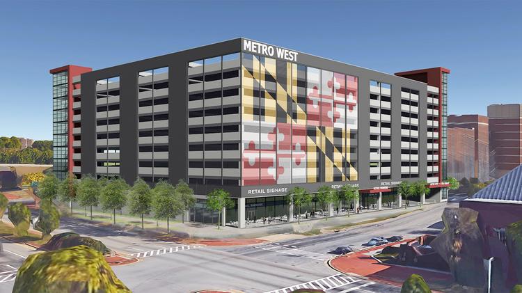 |
| Metro West parking garage proposed by developer Caves Valley Partners, with retail frontage along Saratoga Street to the south. MLK Boulevard is to the left (west) foreground and a bit of the "Highway to Nowhere" eastbound overpass can be seen in the left (north) background. |
Step Minus One: Proposed massive Metro West parking garage
The first step in Metro West's redevelopment process has been a very bad one. The developer's recent plan plops a huge 2200 car parking garage down on a large vacant parcel (shown above) with no clue as to how it relates to anything, thus violating just about every principle of good planning. This parking garage plan was quickly rejected by the city's Urban Design and Architectural Review Panel.
The fundamental problem with the monster Metro West parking garage proposal isn't simply how big, ugly and imposing it is. The problem is that it needs to fit properly into a comprehensive plan for the entire six square block site, and it just can't.
The parking garage site simply eludes all possibilities for good planning. It sit on a "superblock" that is far too big, bounded by Saratoga, Greene and Mulberry Streets and Martin Luther King Boulevard, equivalent in size to three square blocks, which creates a fortress mentality. This means it inevitably creates dead spaces, or "border vacuums" as Jane Jacobs called them in her seminal book, "Death and Life of Great American Cities".
The small ground level retail space shown on the Saratoga street frontage is a very lame attempt to address this problem. The chances of any kind of healthy retail being attracted here is somewhere between slim and none.
But all the frontages surrounding this garage site would be similarly desolate. To the south, the other side of Saratoga Street is the derriere end of the University of Maryland campus. MLK Boulevard to the west is just a huge congested traffic artery. To the east is the rear "service entrance" for the existing Metro West complex and to the north is the "Highway to Nowhere" as it slices through the site - possibly the next location for the nomadic homeless camp as the city chases it away from site after site.
Planners can deal with perhaps one, two or maybe even three dead sides to a development site, but not all four. Here they decided to pretend that the Saratoga Street frontage was somehow viable, but it really isn't.
 |
| Proposed connection of Myrtle Avenue in Heritage Crossing (left, northwest) and Pine Street through Metro West (right, southeast) which I proposed in 2011. This plan also includes the elimination of the north (westbound) overpass of the "Highway to Nowhere" over MLK Boulevard and the southward relocation of Franklin Street (foreground, west). (I apologize for showing the new buildings about twice as tall as I should.) |
Steps One to Five to fix the problem
The problems created by the proposed parking garage cannot be solved in isolation, but can be solved with a wide-ranging step-by-step plan:
1. Create an attractive human-scale street spine through the Metro West site - Fortunately, this is possible to do. Pine Street to the south through the University of Maryland campus has the potential to be such a street. Myrtle Avenue to the north through Heritage Crossing, flanking beautiful Perkins Park, is already such a street. They simply need to be connected, which is what the meandering (a la Olmsted) yellow line through the graphic above indicates. This street could be designed to carry no through traffic, since it could have no median opening at its crossing of MLK Boulevard adjacent to Heritage Crossing. It would approximate the southern extension of Myrtle Avenue which existed from the nineteenth century until MLK Boulevard was built in the late 1970s.
2. Distribute the new parking with new development - Instead of building a single dominant 2200 space parking structure as recently proposed, the parking should be spread to at least two major new structures with "wrap around" office space or other new development along its outer edges. The new Myrtle-Pine spine would actually facilitate this by created an attractive local street frontage for both development sites on either side of Mulberry Street, while not seriously reducing the footprint size of the buildings.
The developer's proposed retail frontage along Saratoga Street would then have a context to be able to function properly, and more retail frontage could be added along the new spine. Saratoga is also proposed as a street to locate a revised west-only light rail Red Line, and this would be an ideal place to put a station, although we know from the Howard Street experience that this alone is not sufficient for revitalization. The retail uses would also compliment the free-standing suburban-style Rite Aid drug store just across MLK Boulevard, which was recently renovated after suffering major damage in the 2015 riots. In the long run, this Rite Aid could be replaced by higher density development as the depressed property values hopefully increase to what they should be.
3. Tear down the northern overpass of the "Highway to Nowhere" and consolidate traffic on the southern half - We know that the "Highway to Nowhere" can be closed with little adverse effect to traffic, as has already been done numerous times for various peripheral construction projects. But while the "Highway to Nowhere" is extremely detrimental to its adjacent community environments, it is probably best to retain one of its two overpasses over MLK Boulevard so that all its traffic does not need to use the intersections with the similarly heavy MLK traffic. Consolidating traffic on the southern overpass would keep it as far as possible away from Heritage Crossing, to facilitate its expansion. This traffic diversion should also allow Franklin Street to be shifted away from Heritage Crossing as well, and perhaps even allow Mulberry Street to be closed just east of MLK to serve only as part of the Pine Street local circulation for Metro West.
In any event, demolishing just one overpass would eliminate the worst aspect of the "Highway to Nowhere", which is its isolated dead space between the eastbound and westbound highways. The single remaining overpass would actually be quite open and airy, and very compatible with an attractive development plan for the adjacent parcels. MLK Boulevard will remain a formidable barrier and the single overpass, open to both people and vehicles, will bridge it.
4. Restore and reopen Fremont Avenue between Franklin and Mulberry Streets through the "Highway to Nowhere" corridor - Old Fremont Avenue is the point where the highway makes its transition from being down in a ditch to the west, to being up on overpasses to the east. It is also the point where pedestrians now dangerously walk across the formerly Interstate highway. By rebuilding and reconnecting Fremont Avenue with traffic signals, the communities would become more unified and the crossings would be safer and more pedestrian-friendly.
A newly reconnected Fremont Avenue would also make an ideal location for an additional station in a revised Red Line plan, because it would not be down in the "ditch" like the planned Harlem Park station to the west. The community of Fremont homeowners just to the south sued the MTA to stop the Red Line tunnel under Fremont from the cancelled Red Line plan.
5. Get rid of the "Highway to Nowhere" in up to six phases to accommodate new development - The city doesn't need to get rid of the "Highway to Nowhere" all at once. The first two steps were already taken at the west end of the highway when its retaining wall was demolished and Payson Street was reconnected through the corridor. These projects were time consuming and lauded as a big deal, but they were really just preliminary. The third step would be to build the connecting roads that will enable the north (westbound) bridge over MLK Boulevard to be knocked down and allow both directions of traffic to be consolidated on the south overpass. One lane in each direction will be sufficient on this bridge and even leave room for new sidewalks and bike lanes, since this will no longer be an expressway.
The fourth and fifth steps will be to complete the new local north-south streets: Fremont Avenue across the corridor and Pine Street underneath the overpass to Myrtle Avenue in Heritage Crossing. The sixth and final step would be to close the remainder of the "Highway to Nowhere" in the mile-long ditch between Fremont and Payson to create a development and greenway corridor, as depicted in the rendering below.
 |
MTA rendering of the Harlem Park Red Line Station, with the "Highway to Nowhere" removed and replaced with new development
by Marc Szarkowski, The existing Calhoun Street overpass is seen in the background (to the west).
|
Step Zero: Plan comprehensively !!!
Right now, Metro West's developer appears to be acting under the assumption that since it paid a bargain basement price for the property, this will be a bargain basement project. Not only did they recently submit a bare-bones generic garage plan, they have also advertised for a "pad site" development, which is real estate parlance for a free-standing suburban-style use like a gas-convenience-fast food outlet.
But the city can't afford cheap shortcuts because this is a critical location and resource for the success of all the west downtown and northwest city neighborhoods, which are now suffering greatly. That's why the price was so low in the first place.
The city and state have already spent hundreds of millions on various projects in this area, including Heritage Crossing, the University of Maryland, and its Biopark, and have been trying to spend much more on the Howard/Lexington area, the La Cite development in Poppleton and other projects. And all this is just the beginning. Much more investment is needed in Lafayette Square, Harlem Park, Upton and other nearby neighborhoods. Metro Center is as critical as any of them, or perhaps more so because it sits on the fulcrum of downtown and the city's entire northwest corridor.
The first step in all of this is for Caves Valley to work with the city revise the design for the Saratoga Street parking garage so that it fits into a quality comprehensive plan instead of simply appearing to be plopped down on the site. The quality and coherence of Metro West must meet the standards that have already been set by Heritage Crossing, just as any new development would in any high quality city neighborhood.


