 Franklin-Mulberry is often cited as a classic example of an expressway that destroyed a city neighborhood. That may or may not be true, since many city neighborhoods have been destroyed without the aid of new expressways. But what is truly unforgivable is the way that the expressway ruins have been embalmed to virtually the exact same condition as when the expressway was built.
Instead of trying to reweave the shattered city back together, the area remains remarkably as it was then. In that time, has there been any other part of the City that has been so devoid of change but has needed it so much?
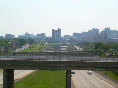
The whole world has changed since 1976, but Franklin-Mulberry has not. The expressway was never connected up to the rest of the Interstate highway system. When I-70 was killed through Leakin Park, the Franklin-Mulberry leg just became Route 40. Even though it was built with three lanes in each direction, it effectively only has two, and it only needs two. Two grade separated and access controlled lanes can carry more traffic than three surface arterial lanes can anyway, so the third continuous lane is of little use, now or in the future.

A wide green swath of the median strip has always been reserved for a transit line. This was a common and expedient thing to do at the time, and in many cities like Chicago and Portland, rail transit lines were indeed built in expressway medians, but hardly anybody has ever been happy with them, cut off as they are from the cities they serve.

There is also a huge swath of leftover land on the north side of the "ditch" next to Franklin Street that has never been used for anything, and a narrower one on the south side next to Mulberry Street. These were even fenced in for many years, as if there was something in there to protect. They are not parkland, nor have they ever been proposed as such, except as some type of default land use born of inertia. For such large parcels of perfectly good land to sit vacant for so long, it can only be concluded that they must truly be considered worthless, even if such an estimation represents more of a defeat for good planning than a socially constructive evaluation.
Moreover, the traffic engineering for old Franklin and Mulberry Streets themselves has never been reevaluated. They are set up to major arterial streets just as they were before the expressway in the ditch was even built. Virtually all of the through traffic has either been diverted to the expressway, or could be very easily, but the streets remain the same.
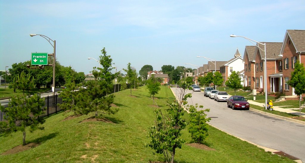
In the past few years, there has finally been some movement in the fossilized Franklin-Mulberry corridor. The first significant sign of life was the Heritage Crossing community, just across Franklin and MLK Boulevard from the expressway. This attractive middle class neighborhood which replaced notorious high rise public housing "projects", has an astonishingly low density for a place so close to downtown. This reflects the very low value of this land - it was not felt that the land's value was sufficient to support a higher density.
As shown above, the planners also felt that Heritage Crossing required huge suburban style buffer strips to separate it from Franklin Street and MLK Boulevard. This is particularly ironic since Franklin hardly even carries any through traffic. It reflects the very suburban-style highway design and traffic engineering of Franklin Street, rather than the actual local function of the road.
The big catalyst for change for Franklin-Mulberry
is hopefully finally upon us. That would be the "Red Line" transit line. Some urban designers believe it would be a mistake to build the Red Line in the highway median of the dead "ditch". But it would be an even bigger mistake to build the transit line up along Franklin and/or Mulberry Street like a slow old streetcar line. This didn't work on Howard Street, which was just as desolate after the light rail line was built in the early 90s as it was before.
Instead, what is needed is to treat the Franklin-Mulberry corridor as an entirely new and unique urban space, not just as an expressway corridor with a transit line. The grade separations created by the big retaining walls for the expressway can be used to make the transit line and the highway work efficiently without conflicts, but in a way that does not cut them off from the community.
The Red Line needs to have fast regional transit connections in order to make Franklin-Mulberry an advantageous location for new development, along with seamless connections between the transit line and the development sites. Creating the best of both worlds will require a unique relationship between the transit line and the surrounding area.
Here's what should be done:
1. Compress the entire expressway into the area on the south side of the "ditch" now occupied by the eastbound lanes. Two lanes in each direction will fit in this space, which is more than sufficient for any traffic volume that may be attracted.
2. Locate the transit Red Line immediately adjacent and north of the consolidated highway. This is the location where the transit line was originally intended, but it would no longer be isolated in the median.
3. New transit-oriented development would then be built at two levels on adjacent parcels. The lower level would be directly adjacent to the transit line, where the westbound expressway lanes are located now. The upper level would be between there and Franklin Street, in the wide green swath illustrated above. Thus, the transit line would have the advantage of total grade separation while also having the advantage of total integration with the new urban development space.
4. The retaining wall between the two levels could be maintained or demolished as needed to support the development. In the three blocks on the west end between Fulton Avenue and the MARC Commuter Rail Station, the retaining walls have been intended to come down anyway to create a permanent expressway terminus where it was originally supposed to have flyover ramps for I-70 to proceed toward Gwynns Falls and Leakin Parks. There is tremendous development potential in this area.

5. The ramp that currently exists between Franklin Street and the expressway adjacent to Heritage Crossing (see above photo) would be one location where the upper and lower levels could be very easily and efficiently connected. This ramp would be converted into a local service road connecting the upper and lower levels. In fact, this would serve as a way of seamlessly integrating Heritage Crossing (left edge of the photo) into the new space with a transit station, and allowing Heritage Crossing to serve as an anchor to demonstrate the marketability of the new development. The ramp and adjacent Franklin Street would be reconfigured to downsize them from Interstate highway design standards to that of local streets. The development potential at this location is particularly unique because of the topography and the huge width of the currently landlocked median strip area.
6. The Franklin Street ramp would be relocated to MLK Boulevard between Franklin and Mulberry, where it would no longer interfere with Heritage Crossing or the new development. This ramp serves almost exclusively MLK traffic anyway, since Franklin Street traffic can get on the expressway downtown just east of Greene Street.
It is indeed ironic that the MTA's Red Line consultants are considering the idea of narrowing Edmondson Avenue west of Franklin-Mulberry down to two lanes in each direction, in an area where such a squeeze would have a dire effect on traffic congestion. But in the Franklin-Mulberry Corridor, which for decades has been nothing but the remains of a dead plan, there is plenty of room for everything.
I like your ideas for this segment, very well thought out! I have always wondered about 'capping off' this spur by building green space over top of it. Imagine a series of interconnected overpasses disguising the utilitarian road-way and red-line underneath. Imagine pedestrian and bike-paths amidst beautifully landscaped park-land. Imagien the boom on Franklin and Mulberry street after the blocks of rowhomes suddenly face a mile long park and a serious transit artery.
ReplyDeleteI think that whatever is done to this space, the important thing would be to 'bridge the gap' that has existed now for 30 years splitting the entire west-side into two pieces. Public spaces, be they commercial or parks, would be best to bring these neighborhoods back together.
I love all your ideas- I hope someone at City Hall is reading your blog-
ReplyDeleteAs I understand it, this expressway resulted from clearing thousands of rowhomes during the Urban Renewal era. It was supposed to become part of I-70 to become an east-west expressway for the city.
ReplyDeleteWhere it ends at it's westernmost point near the train tracks, is a result of a successful effort of westside residents who rose up to prevent the highway from being built through Gwynn's Falls/Leakin Park.
At a red-line transit meeting my breakout group suggested redeveloping the area alongside and including the highway as a transit-oriented development.
We envisioned the red line and a through street on the current roadway with residential and commercial buildings constructed above this corridor.
I believe very little has been done to this community but also in 1968 the City demolished 215 homes in Canton, which gets little recognition and this also diplaced many live look residents, especially for a road that was never built.
ReplyDeleteI say fill the entire ditch in, with the exception of the median. In that space, there could be a cut and cover tunnel for the future red line. On top of it could be placed a linear transit corridor or a pedestrian corridor connecting downtown to the West Baltimore MARC station. The land on either side of the corridor could then be used as mixed use development.
ReplyDeleteThank you, Cnunn! Your opinion is different from mine, but much closer to mine than those recently expressed by some mayoral candidates, this month's Baltimore Magazine and recent transit and development studies. These state variously that the Red Line is no longer worth building in any except possibly the original $3-plus billion dollar form, the "Highway to Nowhere" should not be closed and that the Jones Falls Expressway should be closed instead. I disagree with all three points.
DeleteThe best mayoral answer I've seen is in Thiru Vignarajah's "A Blueprint for Baltimore" to "Create dedicated East-West public transit thoroughfares exclusively for pedestrians, bicyclists, scooters, and buses."
The big question is: What should we do to maximize the net value of the land in the corridor in order to attract development? I haven't heard anyone answer that question specifically, and your answer is as clear as anyone's. Your solution would ultimately be expensive, as would mine, but planners, designers and engineers should craft each specific part of the plans to maximize the benefits relative to the costs.
It almost brings tears to my eyes to remember all of those home-owners relocated for this project. It makes me mad to think that there are those who believe that the Red Line is part of the solution - a return to streetcars? Pull out the studies of the "60's and the solution remains the same - a high speed heavy rail system as shown to be working from Owings Mills to Johns Hopkins Hospital. Please stop trying to reinvent the wheel.
ReplyDelete