For big Port Covington to achieve its over-the-top development ambitions, it's becoming increasingly clear that it will need more than just its own little light rail spur. What is needed is a whole new light rail line that links the rest of the city to the entire three miles of underdeveloped waterfront between Westport, Port Covington, Cherry Hill and Brooklyn.
Both proponents and skeptics insist that the Port Covington project must elevate the entire city, even while admitting that it's isolated from the city and cannot solve the city's economic problems all by itself.
Attention has focused on human development - job training, education, et al - but physical development is what Port Covington is. It must physically fit in to the city even while it necessarily stands out, far more than even Harbor Point. For this, improved transit is the only answer.
The city is now in an extremely odd position. It is fully in bed as a partner with the developer. Port Covington is now "too big to fail".
Splitting the project into manageable increments would be the ideal solution, but that doesn't suit the agendas of either side. Smaller developments would create smaller issues and problems. Instead, the ante has been raised to a dizzying level.
From the physical development standpoint (which has gotten scant attention), two major danger signs have already emerged from this "all in" strategy: (1) Federal rejection of funding for the new Interstate 95 ramps; and (2) Developer Kevin Plank's decision to leave his Westport waterfront land outside his multi-decade Port Covington program.
The new I-95 ramps were probably unworkable anyway, and they couldn't increase overall network capacity. Transit is the only way to do that.
Leaving Westport would out is also understandable from a business standpoint, since Port Covington is so huge already and they don't need the competition. But the Westport community has already suffered from many years of speculation and disinvestment due to previous failures. Some people say Westport must wait its turn, but that only feeds the fear that Port Covington will thrive while poor areas of the city rot.
Will Westport continue being the forlorn town across the river, like East St. Louis or Camden, New Jersey? Westport already has a nearby casino like East St. Louis, and Camden is being considered for one.
The proposed Port Covington light rail spur plan doesn't even include a Westport station. It would just whiz by.
The proposed light rail spur must promote development goals for the entire city, not just Port Covington. Not only would the current plan bypass Westport, it also would not traverse Under Armour's corporate campus at the south end of Port Covington. Instead it would be pushed up against I-95 at the north edge of the site.
Instead, Port Covington's light rail stations should be major development nodes that are built around transit and walkable to the entire site.
The developer's solution is to serve the majority of the site with a "rail circulator" that requires a separate transfer from the light rail line. There has been no case made thus far for this concept and it is almost certainly unworkable and pointless - just one of the toys in the plan.
The plan also includes water taxis and buses, which are nice for some local trips, but not a serious infrastructure plan for a site that must accommodate many thousands of trips per day.
Port Covington needs to be walkable. The light rail stations should be hubs for walking to all the destinations throughout Port Covington, not dependant on transfers to another expensive circulator, especially a rail circulator which has no flexibility to change as needs and conditions change.
There are three more possible major waterfront development sites within a very short distance of Port Covington that can greatly benefit from the same kind of transit-oriented development - Westport, Cherry Hill and Brooklyn, The light rail line should serve all of them.
4 - Redesign Hanover Street in Cherry Hill as major new light rail and local development spine - Through traffic would be shifted to a two-way Potee Street, instead of Potee's current role as the one-way southbound couplet for Hanover, for which both streets are grossly overdesigned. This concept was actually considered in the early '90s as part of the transition of South Baltimore General Hospital to Harbor Hospital, but it was too ambitious for its time. Both Under Armour and the development revolution around Hopkins Hospital have demonstrated that the time is now right for a major new development plan to link the waterfront, Harbor Hospital and Cherry Hill to the rest of the city.
 | |
|
Attention has focused on human development - job training, education, et al - but physical development is what Port Covington is. It must physically fit in to the city even while it necessarily stands out, far more than even Harbor Point. For this, improved transit is the only answer.
Two early danger signals from the "all in" strategy
The city is now in an extremely odd position. It is fully in bed as a partner with the developer. Port Covington is now "too big to fail".
Splitting the project into manageable increments would be the ideal solution, but that doesn't suit the agendas of either side. Smaller developments would create smaller issues and problems. Instead, the ante has been raised to a dizzying level.
From the physical development standpoint (which has gotten scant attention), two major danger signs have already emerged from this "all in" strategy: (1) Federal rejection of funding for the new Interstate 95 ramps; and (2) Developer Kevin Plank's decision to leave his Westport waterfront land outside his multi-decade Port Covington program.
The new I-95 ramps were probably unworkable anyway, and they couldn't increase overall network capacity. Transit is the only way to do that.
Leaving Westport would out is also understandable from a business standpoint, since Port Covington is so huge already and they don't need the competition. But the Westport community has already suffered from many years of speculation and disinvestment due to previous failures. Some people say Westport must wait its turn, but that only feeds the fear that Port Covington will thrive while poor areas of the city rot.
Will Westport continue being the forlorn town across the river, like East St. Louis or Camden, New Jersey? Westport already has a nearby casino like East St. Louis, and Camden is being considered for one.
The proposed Port Covington light rail spur plan doesn't even include a Westport station. It would just whiz by.
Transit linking into the entire city
The proposed light rail spur must promote development goals for the entire city, not just Port Covington. Not only would the current plan bypass Westport, it also would not traverse Under Armour's corporate campus at the south end of Port Covington. Instead it would be pushed up against I-95 at the north edge of the site.
Instead, Port Covington's light rail stations should be major development nodes that are built around transit and walkable to the entire site.
The developer's solution is to serve the majority of the site with a "rail circulator" that requires a separate transfer from the light rail line. There has been no case made thus far for this concept and it is almost certainly unworkable and pointless - just one of the toys in the plan.
The plan also includes water taxis and buses, which are nice for some local trips, but not a serious infrastructure plan for a site that must accommodate many thousands of trips per day.
Port Covington needs to be walkable. The light rail stations should be hubs for walking to all the destinations throughout Port Covington, not dependant on transfers to another expensive circulator, especially a rail circulator which has no flexibility to change as needs and conditions change.
 |
| Large transit-oriented waterfront redevelopment areas in working-class Cherry Hill and Brooklyn, showing four proposed light rail stations |
There are three more possible major waterfront development sites within a very short distance of Port Covington that can greatly benefit from the same kind of transit-oriented development - Westport, Cherry Hill and Brooklyn, The light rail line should serve all of them.
A Westport to Cherry Hill to Brooklyn Light Rail Line
A better solution is thus to build a much larger light rail spur that connects all the potential waterfront redevelopment areas in a three-mile corridor from Westport to Port Covington to Cherry Hill to Brooklyn. This line can be implemented in clear and do-able steps:
1 - Build a "North Westport" station now - along the current Central Light Rail Line, near or just south of where the line goes underneath I-95. This will be a link to a first phase for the Westport waterfront redevelopment, a connection to the casino area (including the abominable new Greyhound Bus Station) and a future transfer station for light rail trips to and from BWI Marshall Airport.
2 - Include light rail in the upcoming Hanover Street Bridge study. Incorporating light rail in the major Hanover Street Vietnam Veterans Memorial Bridge rebuilding plan would be much more efficient than considering light rail from scratch. Three alternatives for light rail could be: (1) part of a whole new replacement bridge, (2) a great way to reuse the current historic bridge for "people" uses like fishing, bikes and pedestrians, with the heavy traffic shifted to a new parallel bridge, or (3) operation of light rail in mixed traffic lanes incorporated into a renovation of the current bridge.
3 - Have light rail go through the entire Port Covington site, not just the north end - Light rail must be designed to be the source of the vast majority of the new access capacity for the entire development.
 |
| Grossly overdesigned one-way northbound Hanover Street in Cherry Hill could be downsized to a local light rail street. To the right (east) only Harbor Hospital and vast seas of surface parking stand between here and the waterfront. To the left, various low-grade suburban-style parcels ripe for redevelopment sit between here and the Cherry Hill community. |
4 - Redesign Hanover Street in Cherry Hill as major new light rail and local development spine - Through traffic would be shifted to a two-way Potee Street, instead of Potee's current role as the one-way southbound couplet for Hanover, for which both streets are grossly overdesigned. This concept was actually considered in the early '90s as part of the transition of South Baltimore General Hospital to Harbor Hospital, but it was too ambitious for its time. Both Under Armour and the development revolution around Hopkins Hospital have demonstrated that the time is now right for a major new development plan to link the waterfront, Harbor Hospital and Cherry Hill to the rest of the city.
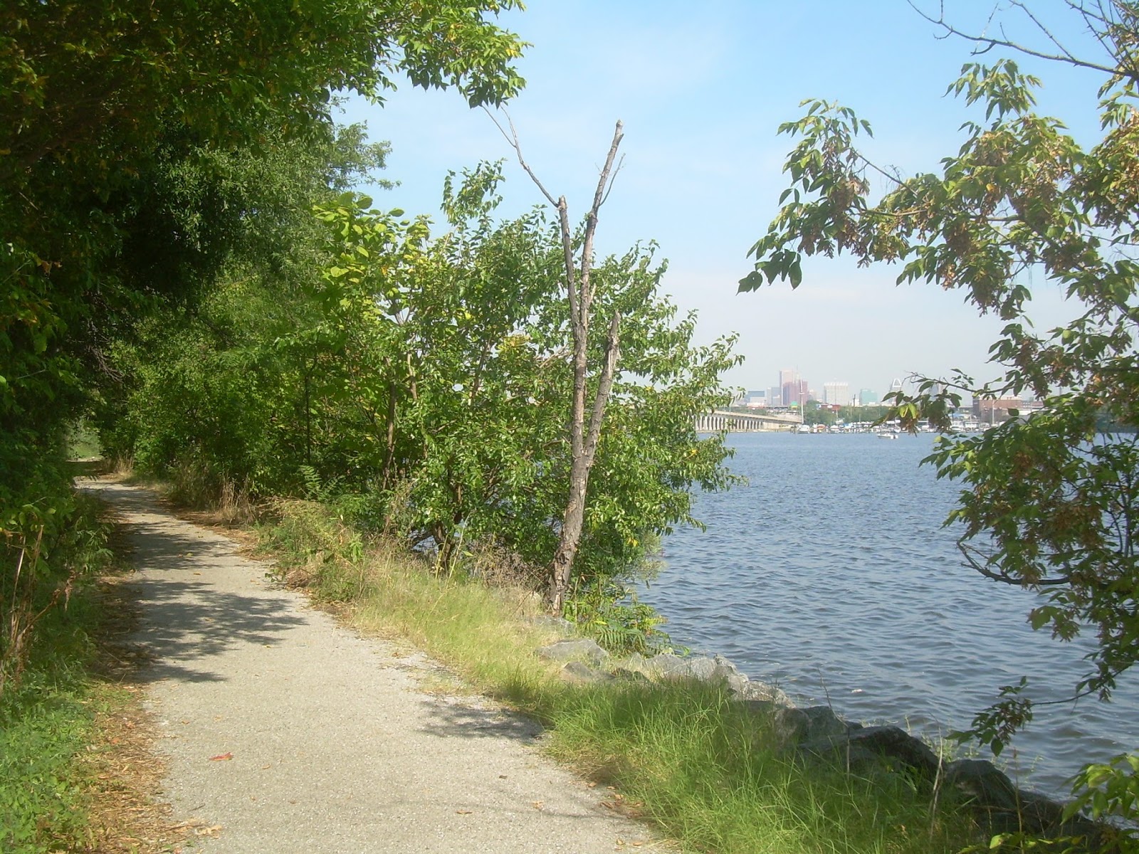 |
| Middle Branch trail adjacent to Harbor Hospital (unseen to the left) - Port Covington can be seen across the water at the north end of the Hanover Street bridge, with the downtown skyline behind it. |
5 - Extend the light rail line southward to Brooklyn - along Hanover Street, to do the same thing. The Brooklyn waterfront is now mostly occupied by the city's largest and most grossly overdesigned intersection at the convergence of Hanover, Potee and Frankfurst. It can be reconfigured and tightened up to create an active new community-accessible waterfront and redevelopment, extending eastward along Frankfurst Avenue on a site now occupied by a concrete plant to the Masonville Cove nature preserve.
6 - Terminate the line on Potee Street in Brooklyn - just north of Ritchie Highway near the city border. This is a vacant site that had been proposed for a courthouse which ran into environmental problems. It can better be developed as a transit hub to intercept bus and automobile trips destined for Port Covington, downtown and the other activity areas. North of here, the light rail line would probably be best suited for an elevated structure to send it over Patapsco Avenue, the Harbor Tunnel Thruway and the CSX railroad tracks.
There has been a lot of talk lately about whether the Port Covington project will help lead us to "One Baltimore" instead of two separate unequal cities that divide the rich and poor. Clearly, Port Covington's geography reinforces this division. A larger light rail project which encompasses both rich isolated Port Covington and the "Other Baltimore" of Westport, Cherry Hill and Brooklyn is the best means of unifying this divisiveness.
But equally important is attracting new development across the entire income spectrum of this "Other Baltimore". This plan would be in a good position to do so because it would serve areas that are not already being developed, but are in a strong position for development by virtue of their proximity to the waterfront.
But development of these other areas needs to happen in concert with Port Covington. It should not just be a slow march of invading yuppies or millennials, such as was started in Federal Hill in the 1970s, before spreading southward to overtake Locust Point and now Port Covington, before then proceeding at a glacial pace over many decades into Westport, etc.
A healthy city attracts geographically broad-based redevelopment. If it merely is seen as an economic tug-of-war between rich developers and a poor city, either the developers will win due to their ability to exploit the city's desperation, or they'll go elsewhere and everyone will lose.
Unfortunately, that's mostly how it continues to be seen. Bishop Douglas Miles of BUILD, one of the leading advocacy groups for the poor in the recent negotiations, proclaimed: "To any developers out there, when you come to the table now, come with your checkbook ready" (Sun, Sept 9).
That sounds like an odd threat toward the people we're trying to lure to invest Baltimore, particularly when it refers to a developer who is poised to be awarded $660 Million in city TIF bond money up front, with the benefits to the city to come later, if at all.
The entire city needs developers and development, and every tool must be seen according to its ability to get it.
 |
| The graffiti and crenelation laden Castle Restaurant on Potee Street in Brooklyn would be adjacent to the end of the light rail line. |
6 - Terminate the line on Potee Street in Brooklyn - just north of Ritchie Highway near the city border. This is a vacant site that had been proposed for a courthouse which ran into environmental problems. It can better be developed as a transit hub to intercept bus and automobile trips destined for Port Covington, downtown and the other activity areas. North of here, the light rail line would probably be best suited for an elevated structure to send it over Patapsco Avenue, the Harbor Tunnel Thruway and the CSX railroad tracks.
"One Baltimore" or Two?
There has been a lot of talk lately about whether the Port Covington project will help lead us to "One Baltimore" instead of two separate unequal cities that divide the rich and poor. Clearly, Port Covington's geography reinforces this division. A larger light rail project which encompasses both rich isolated Port Covington and the "Other Baltimore" of Westport, Cherry Hill and Brooklyn is the best means of unifying this divisiveness.
But equally important is attracting new development across the entire income spectrum of this "Other Baltimore". This plan would be in a good position to do so because it would serve areas that are not already being developed, but are in a strong position for development by virtue of their proximity to the waterfront.
But development of these other areas needs to happen in concert with Port Covington. It should not just be a slow march of invading yuppies or millennials, such as was started in Federal Hill in the 1970s, before spreading southward to overtake Locust Point and now Port Covington, before then proceeding at a glacial pace over many decades into Westport, etc.
A healthy city attracts geographically broad-based redevelopment. If it merely is seen as an economic tug-of-war between rich developers and a poor city, either the developers will win due to their ability to exploit the city's desperation, or they'll go elsewhere and everyone will lose.
Unfortunately, that's mostly how it continues to be seen. Bishop Douglas Miles of BUILD, one of the leading advocacy groups for the poor in the recent negotiations, proclaimed: "To any developers out there, when you come to the table now, come with your checkbook ready" (Sun, Sept 9).
That sounds like an odd threat toward the people we're trying to lure to invest Baltimore, particularly when it refers to a developer who is poised to be awarded $660 Million in city TIF bond money up front, with the benefits to the city to come later, if at all.
The entire city needs developers and development, and every tool must be seen according to its ability to get it.
Good idea, unfortunately we're probably going to get another spur with half-hour headways like the useless one to Penn Station.
ReplyDeleteI agree with Drew. Perhaps a rerouting of the existing light rail, following the R/R corridor going east from M&T Stadium, following Race Street, serving Port Covington, and then heading over the rail bridge to connect to Westport and the existing light rail south towards BWI and Glen Burnie.
ReplyDeleteYes! Finally an idea that really addresses the development inequality in Baltimore, but from a practical and growth-minded direction. I can only hope that those with the power to make decisions are listening.
ReplyDeleteThanks for the feedback, folks. If we want to create a loop instead of a spur for the light rail, I think the best way to do it would be to extend the spur proposed above for this plan back westward from Brooklyn through the area south of Patapsco Avenue and north of Southwest Park, rejoining the existing light rail line between the current Patapsco and Baltimore Highlands Stations.
ReplyDeleteThis is yet another great redevelopment area, with a great parkfront along Southwest Park, a great waterfront along the Patapsco River and great traffic access along Patapsco Avenue. It also has great views (but also soil issues) because it was used as a landfill mountain before its current use for truck storage. This area is shown in the lower left corner of the first map at the top of this blog article.
I blogged about this site way way back over a decade ago, including some great rarely seen views!
http://baltimoreinnerspace.blogspot.com/2006/06/southwest-park-lost-continent.html
https://baltimoreinnerspace.blogspot.com/2007/01/southwest-park.html
I guess it's time to blog about it again.
I was actually working at the City Planning Department when the Penn Station light rail spur was first being planned, and I told them way back then that it was stupid. Nothing we're talking about here is anywhere near THAT STUPID, although it demonstrates again that the MTA and the city have a large capacity for stupidity.
Isn't the spur recreating one of the old streetcar routes after it connects with Hanover street?
ReplyDeleteThe Penn station spur appears to have bridge abutments poured for a second track, and possibly a connection for northbound. What was the plan for that? Was there some intention of the route continuing past Penn station under the JFX?
ReplyDeleteYes, the light rail bridge over the JFX was designed for a second track as you say, but the track at the Penn Station platform is pointing directly into a column holding up the St. Paul Street bridge, so it would be a big expensive mess to ever extend it. There were various plans to do so, but it has never gotten anywhere.
DeleteI don't know anything about the old streetcar route on Hanover, but it makes sense, as you say.
What is MTA's position about this? After the Red Line boondoggle are they looking at rail investment? I appreciate you shining a light on this area as this seems like a great opportunity to capitalize on Port Covington and the seemingly insatiable desire for waterfront land.
ReplyDeleteI have absolutely no clue as to MTA's position about this. It doesn't work that way. But Kevin Plank wants a light rail spur to Port Covington, so that opens up the whole process. The Red Line never had a bigtime private sector advocate like that.
Delete