April 25, 2018

Druid Hill Park: 9 steps to bring it to the neighborhoods

Baltimore's best park is almost totally surrounded by major highways, which not only discourages people from getting to it except by car, but even more crucially, also prevents Druid Hill Park from having the needed positive effect on the health of nearby neighborhoods.

Here are nine critical points where a far better interface between the park and the neighborhoods can be created, presented in the order of how they can be implemented for maximum benefit and minimum disruption.
Nine steps to better Druid Hill Park neighborhood access:
(1) Eutaw Place, (2) Gwynns Falls Parkway, (3) Auchentoroly Terrace, (4) Park Circle,
 (5) Fulton Avenue, (6) Lakeview Avenue, (7) Liberty Heights Avenue, (8) Hampden, (9 ?) Streetcars

"Complete Neighborhoods" are key - not streets


Conditions at each of the nine critical points are different, and not amenable to a single uniform solution. This is how it usually is in traffic planning. The specific conditions, traffic patterns and neighborhood needs and desires of each location are the most important focus.

There's been a lot of talk recently about the concept of "complete streets". Yes, it's a clever rhyme, but uniformly attempting to make every street "complete" by serving every need is pointless, and usually ends up as an exercise in chopping up the pavement space to try to serve every need of cars, bikes, transit and anything leftover for parking, with lots of flexi-posts, signs and stripes to plot it all out. Instead, "Complete Neighborhoods" should be the catchphrase. But what rhymes with "neighborhoods"?

Now there's even a City Council bill to attempt to legislate "complete streets", with a proposal for a new citywide committee to micromanage the entire effort. These people must think the city transportation department is incompetent to do this themselves. Well... so far, they haven't done well in places like the vicinity of Druid Hill Park.

Focusing on specific points rather than whole streets is also a way to implement a plan in easy increments and learn from each step, rather than in one big gulp that may or may not work. So here are the nine critical locations and nine manageable steps to make the wonderful Druid Hill Park accessible to the communities around it:

1- At  Eutaw Place
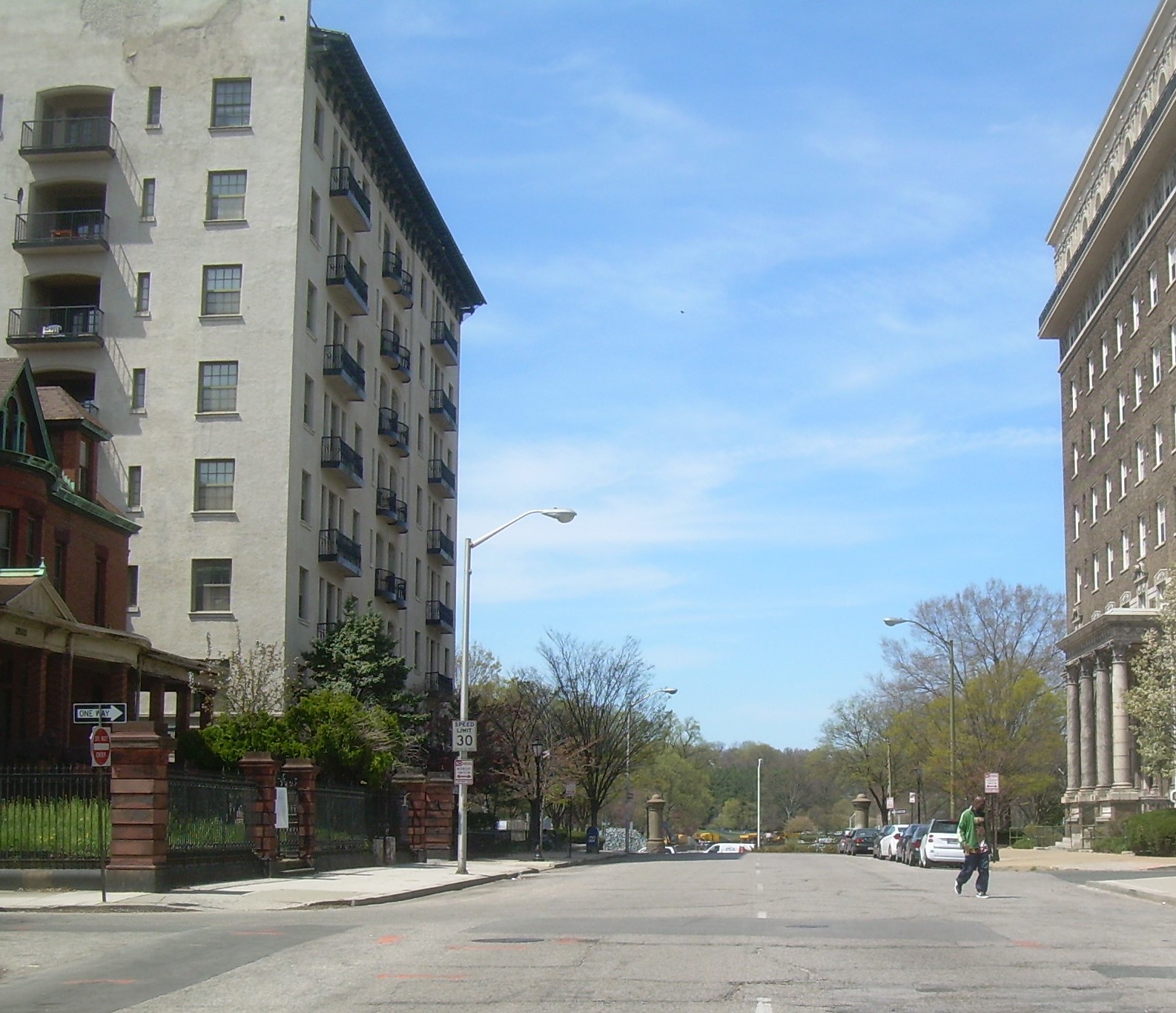
Eutaw Place looking north to Druid Park Lake Drive - all that's needed is to narrow this street down
 to two normal width lanes and do the same to each direction of Druid Park Lake Drive.

This is Druid Hill Park's gateway from Reservoir Hill and all the downtown-oriented neighborhoods. It's also the "low hanging fruit" of all the proposals, requiring only pavement narrowings and no changes in traffic patterns.

The intersection of Druid Park Lake Drive and Eutaw Place simply has far too much pavement in all directions. There are no possible turns off Druid Park Lake Drive, so the third extra lane in each direction is totally extraneous, and ends beyond the intersection anyway. Similarly, the two lanes on Eutaw Place are far too wide and the "free flow" right turn lane was designed as if it is on a major suburban arterial and should be eliminated. Eutaw Place should simply be narrowed to two "normal"-sized lanes at the intersection.

As the current reconstruction of Druid Lake is completed, Eutaw Place will then be a great place to put a new grand pedestrian entrance to Druid Hill Park.

This plan was first presented in a 2013 article in the Baltimore Brew, with urban design aspects provided by Marc Szarkowski.

2- At Gwynns Falls Parkway


This intersection has great significance as the interface between Druid Hill Park and West Baltimore in the historic Olmsted Plan for the city's greenway system. 

In contrast to Eutaw Place, traffic patterns are a major problem here, particularly the heavy left turn from northbound Swan Drive into Gwynns Falls Parkway, which must immediately and unexpectedly stop for the opposing southbound traffic, causing major queueing, confusion and congestion. 

The best thing that could be done here would be to simply prohibit this left turn. There is far more capacity and fewer conflicts for this traffic at the adjacent intersections of Liberty Heights Avenue to the north and Fulton Avenue to the south. This should be tried on a trial basis to assess the impacts before permanent changes are made.

"Try before you buy" is a potent concept that the city should use more often, and is a major benefit of the incremental approach. The only question is whether the city bureaucrats are really prepared for all the ensuing public feedback they would get. But it's far better than some designated committee mulling over hypothetical effects or simply carving up the "pavement pie".

Once the results of this trial are known, the intersection can be redesigned in a far more efficient manner with much more people space and much less traffic space.

The next major benefit would be to redesign the Olmsted greenway connection from Druid Hill Park to Gwynns Falls Parkway, in a similar manner as is now being done on another Olmsted parkway - 33rd Street. Both of these are part of the 35-mile greenway trails network currently being planned by the Rails-to Trails Conservancy.

Finally, the redesign of this intersection must be compatible with the changes planned for the Step #3, discussed below. It's probably best to construct most of the permanent changes for both steps at the same time.

3- At Auchentoroly Terrace

Auchentoroly Terrace - shift both directions of thru traffic over to left side, away from the houses, and turn the median
 into a linear neighborhood park. Druid Hill Park's exquisite Rawlings Conservatory can be seen to the upper left.

This step is the top benefit of the whole nine-step plan. Auchentoroly Terrace has some of the city's most exquisite rowhouses which need to be treasured as befits the way they overlook the city's premiere park. But the adjacent heavy traffic destroys the relationship.

The best solution here is to build new southbound connections within the median strip which consolidate this traffic onto what is now the northbound roadway (called Swan Drive). This is exactly what was done with astounding success on Mount Royal Avenue in Bolton Hill. What was once an isolated median strip then became a linear park, intimately linked to the neighborhood.

Mount Royal Avenue used to have heavy traffic next to these Bolton Hill houses,
 until it was converted into a local street and all the traffic was pushed onto the roadway on the left (note the big truck).
 The same thing can be done to Auchentoroly Terrace.

This proposal was first introduced in a Baltimore Brew article in 2010. That article linked it to a larger plan that extended beyond Liberty Heights Avenue to the north. Christopher Nunn later made a thoughtful comment to the article explaining how an overpass at Liberty Heights Avenue could be avoided. He proposed a traffic dispersion plan that may or may not work, but demonstrated how too much change should not be attempted at once.

The easy part of this plan is the southbound connector links south of Liberty Heights Avenue and north of Fulton Avenue that would divert the heavy through traffic away from the houses on Auchentoroly Terrace, and open up the present median strip for use by the neighborhood.

New path for heavy southbound traffic between Liberty Heights Avenue (left) and Fulton Avenue (right),
 away from adjacent houses and freeing up the median strip to be used as a neighborhood oriented park.

The more difficult part is how to handle the intervening intersection with Gwynns Falls Parkway. However, that should be determined prior to this in Step #2. Physically, the design should become clean and clear, but for traffic operations, it may be tricky. That intersection is already set up operationally as if it was two separate signalized intersections, one with Swan Drive (northbound) and one with Auchentoroly Terrace (southbound). That odd arrangement is currently a disadvantage, with most turning traffic needing to stop twice, but it may be the key to actually making it work. We'll find out.

4 - At Park Circle


This five-legged intersection of Reisterstown Road, Park Heights Avenue and Druid Park Drive, at the extreme northwest corner of the park, was once actually a roundabout. Then in the 1950s, it was chopped up and made into the confusing auto-dominated hodge-podge intersection it is today, with the sixth leg into the park itself cut off completely.

About a decade ago, the city proposed that the roundabout be restored, but nothing became of that plan - probably because it was part of a larger plan to install roundabouts at all kinds of other crazy places, most notably Key Highway and Light Street in the Inner Harbor.

But Park Circle was actually designed originally to be a circle, and so it should be returned to being a circle. The primary benefit of roundabouts is that they subordinate the intersecting traffic streets and promote the place itself. Park Circle is indeed a place that needs to be celebrated as the southern culmination of the Park Heights neighborhood, its only gateway to Druid Hill Park, and really the only point at which that huge neighborhood interfaces with the rest of urban Baltimore.

Roundabouts aren't great for pedestrians, but Park Circle could certainly be made far better as a roundabout than it is now as a confusing five-legged intersection. And certainly better than its current all-but non-existent entrance to Druid Hill Park.

Something really special should be installed in the central focal point of the circle - a monument or sculpture. Traffic demands would dictate that this is off-limits to pedestrians, but that just means the object should avoid small inscriptions and could be made somewhat less vandalism-resistant than otherwise.

The original Park Circle also had to accommodate streetcars, which was no doubt another problem. So the new design should consider the needs of a possible future streetcar line (as per Step #9 below).

Rebuilding Park Circle could be done anytime, but since it would be a fairly expensive and time-consuming project, it is listed here as Step #4.

5- At Fulton Avenue


The downsizing of the horribly oversized intersection of Fulton Avenue, Swan Drive, McCulloh Street, Druid Hill Avenue and Druid Park Lake Drive was the focus of this recent 2017 blog post, which makes the case that it should be driven by major new adjacent development. The city isn't quite ready for that yet, so hopefully it will be by the time some of the previous steps take place.

This is a critical location because it is right where Reservoir Hill, Mondawmin, and much of the North Avenue corridor intersect.

6- At Lakeview Avenue

Lakeview Avenue in Reservoir Hill, looking toward Druid Park Lake Drive, with Druid Lake on top of the mound in the
 background. A pedestrian bridge to the lake can be built as part of new development on the vacant lot in the foreground.

Another park connection which would be development-driven is at the vacant lot in Reservoir Hill overlooking Druid Lake between Brookfield and Lakeview Avenues. The city has made numerous attempts to find a developer for this site and has always failed, indicating that it's still not ready. However, the neighborhood has been great progress so it should happen eventually, especially after the lake is rebuilt.

Other issues are that the site is quite submerged relative to the man-made lake, and traffic noise is quite high, so a high rise development will be necessary to disorient the building from the street level. So it should be a major project.

As such, including a pedestrian bridge to the development plan would be a valuable feature, to provide a direct connection to the lake and its jogging loop for residents and the rest of the Reservoir Hill neighborhood. And as always for pedestrian bridges, intelligent design is essential. No helix or switchback ramps! There's already one of those a block away over Mount Royal Terrace (built with the JFX in the early 1960s), and practically no one uses it.

7- At Liberty Heights and Greenspring Avenues


This location is a critical pedestrian connection between the Mondawmin Mall/Metro Station and the Maryland Zoo. This Baltimore Brew article makes the case for an overpass for Auchentoroly Terrace to create a direct  pedestrian connection underneath. Minimizing traffic conflicts would also enable the minimization of pavement, down to a single lane in each direction northward to Reisterstown Road, where there is now the equivalent of eight lanes through the park adjacent to the new Parks and People headquarters.

A two-lane bridge designed by subtly changing the surrounding topography could have the grace and elegance of similar bridges in New York's Central Park.

But such a project could be expensive overkill. An overpass would only accommodate through traffic, not the heavy turning volumes which could get even heavier. What is needed is to crunch the traffic volume numbers for all movements in the intersection at various stages, particularly after Step #3. Something should be done, but perhaps a less ambitious but more cost effective solution can be designed without an overpass.

8- At Hampden and the Jones Falls Valley

Possible new Hampden Gateway to Druid Hill Park shown in yellow at the end of Ash Street.
The connection would proceed underneath the Jones Falls Expressway (I-83).

The large Hampden neighborhood is totally segregated from Druid Hill Park by the big, bad Jones Falls Expressway (JFX, I-83). There is, however, one point where the JFX is up on a large overpass and the topography of the park is gentle enough to allow a gateway to be created. This location is in the vicinity of Ash Street and Clipper Mill Road, several block south of the west end of 36th Street.

All that would be needed is a small bridge over the Jones Falls stream bed and a grade crossing of the light rail tracks. The Jones Falls Valley has recently become an important regional recreational resource in its own right and this connection would enhance it greatly.

The Jones Falls greenway trail now provides good connections to the park from Woodberry to the north and Wyman Park / Remington to the southeast, but nothing in the vast section between.

Ever since the light rail line was being planned in the 1980s, a park connection has been contemplated to the Woodberry Station, which is well served from Union Avenue in Hampden. However, this is an extremely remote section of the park with very steep topography, so nothing has never gone anywhere with this idea.

A new Druid Hill Park gateway near Ash Street is the best alternative. Druid Hill Park is big enough and significant enough that it needs to serve the entire city as well as possible. Bringing in a larger citywide and regional clientele will then summon resources to improve the park for everyone.

9- For Streetcars


Druid Hill Park was originally developed with streetcar money, back in the glory days when the city's streetcar system was built with private money and was actually profitable enough to tax. (Nowadays of course, tax money flows into the transit system, not out.)

So streetcars in the park is not a far-fetched idea. One concept would be to start a streetcar line at the Mondawmin Metro Station transit hub, run it into the park along Liberty Heights and Greenspring Avenue to serve the zoo, then northward to Park Circle and along Park Heights Avenue to the prime Pimlico Racetrack development area (see three part Pimlico blog series that begins here). Park Heights Avenue in particular is perhaps the most suitable streetcar street in the entire city - big and wide and not too congested, and lined with what should be attractive houses.

South of Mondawmin, the streetcar line could run right through the Coppin University campus and then down North Avenue. (See my streetcar system slide show here.)

The most important rule for developing a streetcar line is that it MUST be driven by new development and urban design. The technical advantages of streetcars over buses are elusive enough that streetcars can practically never be justified only on the basis of mere transportation.

Washington DC's H Street corridor is a prime example of how to use streetcars as a catalyst for redevelopment. Baltimore's far more pretentious Howard Street corridor is a prime example of how NOT to do it. In both cases, the rail line itself has been just one factor in the development process.

So a streetcar line in this corridor must be driven by a very serious redevelopment plan for Mondawmin Mall, with real genuine transit orientation this time (not fake like the Target store and Shoppers Food Warehouse), plus a very serious plan for Pimlico Racetrack, plus a very serious plan for Park Heights Avenue itself (after numerous false starts over past years and decades).

But building the new and improved gateways into magnificent Druid Hill Park as proposed here would be a serious first eight steps.

March 31, 2018

Growth fueled by transit - but only in the right places

Lack of rail transit has always been included in the litany of reasons for Baltimore's steadily declining population, with critics usually pointing specifically to the cancelled Red Line, including The Baltimore Sun's recent (March 26) editorial.

But there has never been a correlation between rail transit and growth in Baltimore. There could and should be - but there hasn't been. Rail transit has its advocates, and so does development, but they seldom properly put them together. It even looks like a conspiracy with rich developers and normal working folks working together to keep them apart. Such unity of purpose is rare in this city.
Oldham Crossing - a project made possible by the cancellation of the Red Line,
which would have been on a 70 foot high elevated structure where houses are getting ready to be built.

Red Line experience


Developers actually wanted to keep the proposed Red Line stations as far away from growth as possible. Harbor East developer John Paterakis forced that area's station to be pushed as far away as possible from the critical Central Avenue development corridor, which is also the spine for Harbor Point which is now under construction by Michael Beatty.

The same is also true for the Canton Crossing development, where the proposed Red Line station was pushed into the median strip of Boston Street so that the ongoing development could be as disoriented from transit as possible, with full resemblance to a typical auto-dominated suburban strip center.

All these areas are booming right now, even with the dead Red Line. Other projects that have benefited include the 173-unit Oldham Crossing townhouse development between Greektown and Bayview. The Red Line was supposed to bisect through the heart of that site on a 70 foot high elevated structure which was necessary to climb over the railroad tracks to the west and Interstate 895 to the east. Without the death of the Red Line, it is highly doubtful that this project would have ever happened.

Another project which had previously been cancelled due to Red Line construction was the rebuilding of the Broadway Market adjacent to the underground Fells Point Station at Fleet Street. The two-block market has now been revived by a different developer, with construction to begin this summer on its first phase on the north block and completed in 2019 to the south. With the half empty market acting as a barrier, Broadway has had the feel of two different streets - the touristy Fells Point waterfront to the south and the Latino-flavored Upper Fells Point to the north.

It is crucial to the integration and continued growth of southeast Baltimore to dissolve this barrier, because Broadway is its main north-south street which needs to serve as a spine for the larger community extending north to Hopkins Hospital and beyond. However, there is still a strong feeling among many that such growth is a threat to either the Latino business district to the north, the tourist restaurants to the south, or both. And there has never been confidence that either the new Broadway Market or the Red Line could solve this problem in a satisfactory way.

Threatening sign at the intersection of Broadway and Lombard Street, just north of the previously proposed Red Line Station, and several weeks after the annual deadline for police enforcement.

Adding to this controversy is the city's "official" policy of cracking down on employers who pick up workers along Broadway, who are otherwise seen as loiterers. However, despite the longtime presence of signs threatening that police will provide enforcement, this policy seems to be a "nod and a wink", unlike similar signs and policies elsewhere in the city aimed at homeless camps. The threatening signs don't even have a stated year of applicability, so as soon as the doomsday deadline passes for one year, as it did a few weeks ago on March 3rd, the threat simply renews for the next.

Meanwhile, the growing Latino population is one of the city's few bright spots in terms of both growth and diversity, amid the continuing fleeing to the suburbs by whites and blacks alike. However, long term trends may point to increasing Latinos, Asians and other ethnic groups fleeing to the suburbs as well. There's not much evidence that any one ethnic or racial group inherently likes the city any more or less than the others. Washington, DC has gotten publicity from its growing white population, with blacks no longer being in a majority, but there is no evidence that this could repeat in Baltimore.

Harlem Park Red Line Station - the official plan is shown on the bottom, with no adjacent transit oriented development, just the "Highway to Nowhere". Some community folks preferred no development, which they viewed as a gentrification threat. Replacing the highway with transit oriented development is shown on the top view.


Meanwhile on the west side of town


On the west side of town, the Red Line was planned to be down in the trench of the "Highway to Nowhere" where it would be as far away from its surrounding urban activity as possible. This truncated Interstate highway has proven to be obsolete, but the planners have steadfastly avoided any push to get rid of it and replace it with new urban growth.

Low income residents have to a large extent been like-minded with the high-powered developers. Many of them feared that the Red Line would bring "gentrification" where new higher income development would push the existing low income residents out of their communities. So even though the attraction of new development is virtually the very definition of growth, they opposed it. Instead of gentrification, they wanted any new higher income development to be linked to a proportional amount of new low income development, which has previously been a stumbling block to getting any development at all.

This process has played out at the Uplands housing development just south of what would be the Edmondson Village Red Line station. But only the first phase has been built and the project started languishing long before the Red Line was cancelled. There is still hope for the project, its large swaths of vacant land and its incredible but crumbling historic mansion, but the plan has never been physically oriented or integrated to the planned Red Line in any meaningful way.

Previously built rail transit lines - and the future


None of these trends are new or unique to the Red Line plan. The Baltimore Metro rail line built in the early 1980s, was supposed to attract new growth to the State Center, Mondawmin and Reisterstown Plaza stations, among others. A limited amount of nearby new development has occurred over the ensuing four decades, but virtually none of it has actually been oriented to the transit stations.

In the early 1990s, the Metro was augmented by the central light rail line. The State Center and Lexington Market station areas served both lines, and both corridors have only become increasingly desolate over the years. Attempts to attract new development have increasingly called for major subsidies, even though many hundreds of millions were already spent to build the transit lines in the first place. And even these major subsidies have been futile.

Two other station areas along the light rail line were specifically targeted for transit oriented development - Westport and Cold Spring Lane. Both have gotten practically nothing in the four decades since.

At this point, the future remains grim, and closely follows the well-established trends. The multi-billion dollar Port Covington project does call for a short spur from the central light rail line into the development site, but this would be located along the extreme northern edge of the site underneath the Interstate 95 Viaduct, as far away from most of the new development as possible.

The Port Covington developer, Kevin Plank, also owns the nearby vacant Westport property which is already served by light rail, but the Westport development has been placed on the back burner so that it won't compete in the foreseeable future.

Ironically, in Plank's effort to attract Amazon to build its second headquarters at Port Covington, some people blamed the death of the geographically far-away Red Line for the failure. But Plank's proposal to Amazon barely even mentioned that the Westport site was ready and available and already had excellent light rail access to downtown, BWI-Marshall Airport and other destinations. If rail transit was so important, the Westport site should have been made into a major selling point.

The challenge: Integration instead of isolation


The apparent bottom line is that isolation is now the number one selling point for major new development in Baltimore, rather than connectivity or integration. Both of the city's current top development sites, Harbor Point and Port Covington, are located out on waterfront peninsulas where they are perceived as divorced from the city's urban and social problems. This also means they are away from most of the city's transit system.

As a result, there are calls for the transit system to be extended, so that low income, transit-captive city residents can gain access to the new development. But the new development would not be oriented to the transit, so the low income residents would remain in the background.

This perpetuates the theme of "Two Baltimores", one rich and one poor. Actually, many people on both sides appear to like it that way. The anti-gentrification faction doesn't want the rich and poor to mingle together for fear of displacement, and the developers are only too willing to comply. Of course, this compliance would be on their own terms, because obviously development will not happen unless developers are willing to do it.

So where do we go from here? If there is one simple basic lesson over the past forty years, it is that expensive, comprehensive, sweeping visions have not worked. During all this time, Baltimore is still grappling with the same basic problems of simply getting developers to oriented their development to transit. Sure, the city could subsidize the bejeebers out of it, as we have already attempted. But such force-feeding is merely a ploy to avoid the real trends.

The city simply needs to identify one or more projects that beat all the negative trends that have been building over the past forty years - projects that truly orient the transit system to new development, that truly unify rather than divide the city, and that are actually affordable and buildable.

These projects don't need to be on a new transit line. They simply need to promote a culture of transit. Large numbers of people don't tend to use transit unless they really need to. Even in New York City, a major transit capital of the world, people basically use transit simply because they need to.

The primary selection criterion should be that the initial scope of the project should be limited, but its ultimate ambition should be open-ended. Projects should feed off each other rather than competing with each other.

Often, the value of a project is based on creating the perception of scarcity. Port Covington and Harbor Point are both inherently like this because they are on peninsulas. It's the old sales pitch: "Quantities are limited so buy now !!!!"

The real city works in exactly the opposite manner: Potential is unlimited, which depresses the urgency to buy in the short-term. It's very risky to be a lone pioneer.

The best way to counteract this problem is to create projects with significant increases in property value which can support high densities. Too much of Baltimore has become dirt-cheap land which is only developable with massive subsidies.

Top Ten Candidate Development Projects


OK, here is a Top Ten list of candidate projects, drawn from throughout this blog, that can move the city out of its current conundrum and toward its unlimited future potential. They are all related to transit, because long-term urban growth is always dependent on transit, but they are not contingent upon building any particular new transit line.

May the best project win!

1 - Replace the "HIGHWAY  TO NOWHERE" with a transit-oriented development greenway from the Metro West site, through Heritage Crossing to the West Baltimore MARC Station.

2 - Create a transit oriented development plan for the COLD SPRING LANE light rail station, renamed "WEST ROLAND PARK", incorporating and integrating the areas from Cylburn Park to Cross Keys.

3 - Create a transit oriented development plan for the WESTPORT light rail station area that really works.

4 - Create a transit oriented development plan for STATE CENTER that really works.

5 - Create a transit oriented development plan for PERKINS POINT - currently the Perkins Homes public housing complex, that really works.

6 - Create a LEXINGTON MARKET TRANSIT HUB, incorporating and integrating the Metro and light rail stations.

7 - Create a transit oriented development greenway along the "B&O RAILROAD FIRST MILE" and the north edge of Carroll Park from Mount Clare to Montgomery Park.

8 - Create a transit oriented development SOUTH WATERFRONT GREENWAY from the Middle Branch at North Westport, though Port Covington and the Locke Insulator site to Cherry Hill and the Harbor Hospital site to Brooklyn and finally to the Masonville Cove nature preserve.

9 - Create a transit oriented development JOHNS HOPKINS HEALTH CORRIDOR from the main medical campus to Bayview.

10 - Create a new UPLANDS PLAN with more upscale housing oriented to the nearby high-end Ten Hills neighborhood and the incredible Uplands mansion.

The purpose of the higher end housing is not just to make more money or to kowtow to disgusting rich people who we all love to hate. The purpose is to create higher land values to support higher density and to create a transit orientation. Once this is established, wonderful "salt of the earth" poor folks will willingly move into smaller, lower cost co-op or rental units. "The meek shall inherit the earth."

February 8, 2018

Shovels "ready" - but Amazon says Baltimore isn't

Not ready. That's how Susan Yum of the Baltimore Development Corporation, the quasi-public arm of city government, described why Amazon rejected Baltimore for its new headquarters (according to the January 27th Baltimore Sun): "Amazon didn't think Baltimore was ready to host its new office complex..."
This shovel is ready for Amazon, poised on the large front lawn of the Baltimore Sun Printing Plant in Port Covington.
Interstate 95 is in the background to the right..

In a twist of irony, "ready" is also exactly the word that Mayor Pugh used to tout Baltimore's unique advantage over the other 237 proposals from other cities. But the mayor was referring to shovels, as in "shovel ready", not to cities.

Yes, those inanimate shovels are ready. They're poised at Port Covington, behind the new Under Armour sportswear campus and next to the Baltimore Sun's printing plant, bastion of the pre-internet  world that Amazon has been efficiently demolishing ever since it was founded by Jeff Bezos.

Baltimore has been acting as if Amazon would be incapable of getting any shovels ready on its own. As if Amazon was thus going to evaluate all the cities' proposals on the basis of their shovels, not their cities.

It's deja-vu to the 2008-9 "Great Recession", when being "shovel ready" was the top criterion for spending the federal trillion dollar stimulus package, rather than best preparing for the future. As a result, that was the last time that Baltimore had a strong road paving program ("Operation Orange Cone"), but now the roads are crumbling again as the big infrastructure expenditures have now turned to the city's obsolete sewer system and deteriorating schools.

In the interim, the city's big infrastructure project was supposed to be the three billion dollar light rail Red Line. When that imploded or was exploded (take your pick), instead of finding a way to actually make it work, it has just become a weapon for various "I told you so's."

City apologists practically prodded Amazon to say that the lack of the Red Line (which wouldn't have gone anywhere near their site) was the smoking gun that killed Baltimore's proposal.

Of course, Amazon didn't bite. Amazon wasn't even critical of the city's murder rate or school system, much less its transit system. Nashville, Raleigh, Austin, Columbus and Indianapolis all made Amazon's candidate list with clearly meager mass transit systems, while the State of Maryland did promise to build a light rail line to the proposed Port Covington Amazon site.

Baltimore's basic problem is that is always fixated on one project, issue or development site at a time. The shovels should be construed as the last step, not the first.

Baltimore has plenty of great sites for a major new corporate headquarters. Port Covington is only one. Here are ten of them that I quickly identified right after Amazon announced they were looking.

Six Chicago sites for Amazon's new headquarters within several miles of the city center. (City of Chicago)

Other cities did not limit their proposals to one site. For example, Chicago also identified ten sites. Here's a map of six of Chicago's sites within just over two mile of the city center: https://chicago.curbed.com/2017/10/23/16512138/chicago-amazon-hq2-bid

Any proposal can also include phantasmagorical architectural images. Below is an image of one of Chicago's sites rendered by a consultant working for architectural giant Skidmore Owings and Merrill. This site has been dubbed "The 78" because it is not part of any of the city's 77 official neighborhoods. Not being part of the city's neighborhood fabric is thus being sold as an advantage.

These kinds of images may impress the Baltimore City Council and the Sun Editorial Board, but Amazon has probably seen so many of them in the past few months that their eyes have glazed over. Getting out the shovels to build it is the least of their issues.

Image of a proposed Chicago site for Amazon, but it could just as easily be Baltimore (ICON)

So "Amazon didn't think Baltimore was ready..." That's such a succinct, all encompassing way to describe the city's rejection.

What it says is: Yes, Baltimore is definitely moving on down the road. What it doesn't say is where the city as a whole is actually going.

So at the same time, Amazon will be moving down a different road.

February 5, 2018

No Inner Harbor "End Game" for dormant Harborplace

In the 1980s, Harborplace defined the Inner Harbor, so much so that its developer, James Rouse, was often given credit for the entire celebrated waterfront revitalization. But now and for the past year and a half, most of its small shops and eateries have been closed, awaiting a renovation that was supposed to take six months but still has no completion date.
Harborplace with the Questar Tower under construction in the background,
and behind that another residential tower, Harbor Court.

The odd thing is that Harborplace no longer seems to matter all that much, despite what it once meant to the city's image. 

Most of the larger tenants remained open, but they are now practically all national chains like Hooters, H&M, Bubba Gump, Ripley's Believe it or Not, Uno's Chicago Pizzeria and Cheesecake Factory that could be found almost anywhere. Over the years, there had been a previous wave of closures of the original anchors who were unique to Baltimore. The largest and most successful, Phillips Seafood, moved only several blocks to the Power Plant, but most disappeared completely.

Now even the national chains are taking a hit. One of Harborplace's largest retailers, Urban Outfitters, closed this past January 7th. They still have stores in Towson, Tulsa, Spokane, Boise and dozens of other towns and cities, but not here in Baltimore.

The previous September, Harborplace's owner, Ashkenazy Acquisition Corp, announced that one of the two pavilions would be completed in time for the holidays, but that didn't happen and little visible progress has been made.
Harborplace's crapped-up interior mall has been sitting like this for over a year., but now without Urban Outfitters.
 Who knows what's been happening behind those construction walls? 

Inner Harbor 2.0: Tourist mecca


All of this has not kept the city from preparing ambitious "revisioning" plans for the Inner Harbor and its interface with the rest of the city. Amid all this, much change has actually occurred, but mostly not following any script of those visions. And not involving Harborplace, which is ironic considering what it once meant to the Inner Harbor, and still does in legends, lore and iconography.

The big plans have mostly revolved around tourism and visitors. The flagship was a billion dollar replacement and expansion for most of the convention center which would include a huge new arena, hotel and still more retail. Then there was the Baltimore Grand Prix, a "world class" sports event that lasted two years, until a scheduling snafu derailed it long enough so it could be conveniently forgotten. But can we forget what our leaders promised us?

Pratt Street was supposed to be rebuilt as a two-way boulevard with narrower berms and sidewalks to make room for still more retail. A tiny bit of that retail has actually happened - a Shake Shack, Chick-Fil-A and a CVS Drug Store that moved down from a block north. A bikeway was also built that's basically just a glorified sidewalk. Aren't bikes supposed to stay off sidewalks?
One very well received Inner Harbor revision was to widen Pratt Street into a two-way boulevard
 with narrower sidewalks (similar to Conway Street) with a giant video screen replacing McKeldin Fountain
near Light Street to block people's attention away from the old boring Inner Harbor. (Prepared by Ayers Saint Gross)

The major recent project near Harborplace was to demolish the massive McKeldin Fountain which was built soon afterward in the 1980s, essentially reverting the median between Light and Calvert Street to its condition as the grassy two-dimensional "Sam Smith Park" which existed in the 1960s and 1970s. A "Phase Two" has also been talked about, which was geared to a traffic plan that was supposed to be studied a decade ago, the outcome of which was never released.

There have also been many iterations of plans to "reinvent" Rash Field near Federal Hill, most ambitiously as a gateway to a proposed huge pedestrian drawbridge over the Inner Harbor to Pier Six. Rash Field itself would be transformed into an answer to Chicago's touristy Millennium Park. Another idea was to rebuild the park as the roof of a parking garage underneath. Amusement park rides were another idea, and two carousels have appeared over the years, then deteriorated and disappeared. With the onset of time and financial realities, the various plans have continually gotten less sweeping and ambitious, and became more just dabs of this 'n' that.

Inner Harbor is now a neighborhood


Fortunately, all these recent tourism and retail travails have not negatively affected the residential sector, which has been booming near the Inner Harbor. This has been led by the city's tallest residential tower now under construction by Questar Development across Light Street on the McCormick Spice Company site, which has been a parking lot since soon after Harborplace opened in the 1980s. Just a few blocks north on Light Street are the recent conversion of the 34 story Art Deco masterpiece at Ten Light Street from office to luxury residential and a new tower across the street on the Southern Hotel site which stood vacant for decades.

The reasons people are being attracted to live in these high rent buildings is a lively topic for speculation, but an abundance of nearby retail stores is certainly not among them. And office development is not it either, because much of the new residential replaced office buildings.

Tourism and conventions? Highly doubtful. To listen to city leaders over the years, Baltimore's tourism industry has always been only one or two major projects away from fulfilling its vaunted promise, whether it be the billion dollar mega-convention-hotel-arena, the Grand Prix or a pedestrian drawbridge from Rash Field to Pier Six.
Proposed pedestrian drawbridge across the Inner Harbor from redesigned Rash Field (right) to a new center of downtown
 near Harbor East and Harbor Point, that would divert attention way from Harborplace and the old downtown.   

And the rest have been projects that mostly attempt to undo what has already been done. That includes the attempt to turn Pratt Street into a two-way boulevard with narrower building setbacks like the rest of the city, the demolition of the McKeldin Fountain or the various alternative reworkings Rash Field as another Millennium Park.

In fact, much of the recent residential success has happened as a Plan B, after previous Plan A failures for offices, retail or tourism. Then Harbor East became the hot address for both new office and residential, along with Federal Hill and Locust Point. The Questar apartment tower had previously been touted as a site for the Exelon office headquarters before they decided on Harbor Point instead.

Maybe the recent residential boom is merely a product of external economic and demographic factors for which the city has little control.

Maybe the mystique of the Inner Harbor is only a secondary factor. Maybe it's not the brilliance and vision of Baltimore's leaders (usually pointing at Mayor William Donald Schaefer with a bit of help from those who came before and after) who inspired City Planners to create a timeless urban masterpiece.

Just maybe... the Inner Harbor's success was merely a fortuitous outcome of unique urban geography... an estuary of the Chesapeake Bay that fully penetrates into the gut of the city. And so people want to live there.

What goes around comes around


Recently, the city has devoted most of its available resources to other nearby playgrounds for the rich  like Harbor East, Harbor Point and Port Covington that were heretofore seen as offshoots of the Inner Harbor's success. But now the tables have turned the other way. Now the Inner Harbor is the offshoot of those other places.

So the Inner Harbor has already had its turn in the spotlight. It shouldn't demand hundreds of millions more dollars to subsidize the rich. Maybe the rich will embrace the Questar Tower anyway, or maybe it will not command the rents the developers expect, at least not indefinitely. The rich are a choosy lot. The great thing about the law of trickle-down economics is that if it starts trickling from a high enough stratum, it has plenty of room to trickle to the mere well-to-do and then to the middle class.

Trickle-down is only a problem when housing can no longer serve the lower class, and there is no one left to trickle down to. That's when housing is abandoned, as has happened all too much in Baltimore.

But Baltimore now has a unique opportunity near the Inner Harbor to make affordable housing work on a large scale - the Perkins Homes public housing complex redevelopment just north of Fells Point and Harbor Point, which hence could be called Perkins Point. In most instances, density works against the economics of mixed income projects which significantly limits them. But Perkins Point is a rare opportunity where high density can really work because the land has such high value.

This sign is currently (2018) on various mall walls inside Harborplace where retail shops once were. 

As for the constantly changing retail environment, it's a conundrum that's not worth attempts at deciphering by ordinary mortals. Yes, the internet has hurt brick 'n' mortar retail. But since the suburbs had previously clobbered Baltimore's retail sector before the internet ever came along, the internet has actually leveled the playing field.

So the Questar Tower won't have an Urban Outfitters right across the street. Who cares? Just order online, like anyone else.

If anyone actually understands retail anymore, it would be Amazon, which decided to buy Whole Foods Market, which is building a very large new store in Harbor East. Good for them.

And for something a bit more bourgeois bohemian, there's the Broadway corridor in Upper Fells Point, where the strong Latino influence has already withstood the trappings of gentrification. Along with Amazon, ethnic groups seem to have the greatest semblance of understanding urban retail. The Broadway Market has a long woeful tale of attempted renovation similar to Harborplace, but the future should be bright.

In sum, the Inner Harbor has had its heyday. It needs to grow old gracefully and let other places have their share of attention. This too shall pass.

The moral is to invest in intrinsic improvements that genuinely increase value, and don't just feed someone's quixotic or idiosyncratic visions. Real problems need to be solved, like access and traffic conflicts, instead of playing zero-sum games. Was getting rid of McKeldin Fountain really that important? Will a new Rash Field really be a "game changer"? The simple answer is "no".

A strong feasible transformative project that would actually be successful is to narrow down Light Street to what it should have been in the first place.

Perhaps the greatest benefit of Baltimore's Inner Harbor experience is what we can learn from it, as attention moves onward to Harbor Point, Port Covington and the rest of the city. When all is said and done, despite its history of hype, Harborplace will be just a place on the harbor.

January 9, 2018

Port Covington's big spinoff: Locke Insulator site

It didn't take as long as expected for the massive Port Covington development plan to get its first big test as a generator of promised spinoff growth, now that the adjacent Locke Insulator manufacturing plant is being shut down and put up for sale.
Looking northwest at the Locke Insulator site from Ferry Bar Park at the south end of Light Street,
 with the Hanover Street bridge to the upper left. The shut-down Walmart
 which will be part of the Under Armour campus is just to the right (east).

Kevin Plank and his Sagamore/Port Covington team did not want this to happen, especially so soon. They quietly grabbed all the land they could to avoid development competition, most notably the empty Westport waterfront just across the Middle Branch, which has been ripe for new transit-oriented development since long before they arrived.

Plank has been sitting on Westport ever since. Their Port Covington plan was also predicated on Locke Insulator laying fallow the same way, so that their multi-billion dollar plans could grow up around it. Unlike Westport, they won't be able to buy it cheap to lock (pun) it up from competition.

But that's good news for the city - at least as good as the regrettable shutdown of yet another old source of good blue collar jobs could be. Locke lasted longer than most, since like Domino Sugars but few others, it was not labor intensive and thus less vulnerable to national and global competition.

What this means is that the 24-acre Locke site can now complement the Port Covington development, while filling some of the gaps that would otherwise remain. The major spinoff push (politically) has been for low income and affordable housing, which is very unlikely to happen on the current Port Covington site. This is perhaps somewhat more likely on the Locke site, although still not a strong bet compared with various sites throughout the rest of the city and region.

Prime real estate


Two major points stand out that will shape the future of the Locke site:

First and most clearly, the Locke Insulator site is actually a more valuable piece of real estate than most of what Sagamore will be putting on the open market in Port Covington. Sagamore has mostly saved its best waterfront land for Plank's Under Armour campus and his recently completed whiskey distillery. The first parcels to be marketed to the private sector will be part of the landlocked Baltimore Sun printing plant property between Cromwell, Hanover and McComas Streets.

Brand new sea of asphalt parking lot to serve the Sagamore Whiskey Distillery,
on part of the Sun Printing Plant property which is eventually to be developed.
 Note that a bit of the waterfront is peeking through to the right.

But the massive ungainly Sun printing plant will remain standing as long as possible, to postpone the expense and other issues associated with getting rid of it. Plank also maintains hope that Amazon's Jeff Bezos will come along and buy into the plan, and maybe figure out a way to incorporate it into his Washington Post. The Sun also likes to keep saying they have a "long term lease", but the entire newspaper business is now in a constant state of flux.

Moreover, the density of the first new development here will also not be very high, if only because there is so much land available (see this post). The densest development is being reserved for the portion of the land right next to the Interstate 95 elevated structure and farthest from the water, which is expected to happen last for both aesthetic and market reasons.

Congestion and the need for great transit


The second important point is the role of cars and transit. The Locke Insulator site will generate another huge influx of trips and traffic to the isolated Port Covington peninsula. It should thus be more obvious than ever that cars cannot be the dominant transportation mode.

But the current Port Covington plan pushes the short spur from the existing light rail line up to the northernmost edge of the site, along McComas Street and Interstate 95. While this is bad for the Sagamore development, it is totally unacceptable for the Locke Insulator site, which will not be part of the insulated (pun again) "campus-style" environment of the rest of Port Covington and Under Armour.

To one degree or another, Locke will be locked out (sorry). The Sagamore plan puts a long wall of parking garages along Light Street between the Under Armour campus and the Locke site, creating a kind of wide service alley which pushes the cars toward Locke. This can be mitigated by good design, but all that traffic will still be there and needs to be accommodated.

The traffic problems will also be exacerbated by the Locke site's very short 740-foot frontage along Cromwell Street (equivalent to about two city blocks). All traffic must be funneled through this segment, with the vast majority entering at the two existing intersections at Light Street and Insulator Drive. The current Sagamore plan layout attempts to discourage traffic on Cromwell Street, and although it had already seemed unlikely that their attempt would succeed, it is now virtually certain to fail. Cromwell will ultimately be congested - period.

City development policies virtually always call for maximizing new development when it doesn't directly impact an existing neighborhood. City Planners (even me) almost invariably say that that density is good. It would be very unfair and likely legally untenable for the the city to try to limit development density on the Locke site because of traffic, when it sits directly adjacent to the gigantic Port Covington site.

There is really only one solution: The proposed light rail spur must be directed southward through Port Covington to directly serve the Locke Insulator site, instead of being kept out along the northern I-95 periphery as in the current development plan (see this article). The light rail spur must be planned to serve the maximum possible number of riders instead of being directed at the fringe - literally.

A possible extended light rail spur that starts at a new North Westport Station along the existing light rail line,
 extends east to West Port Covington just south of I-95 (west of where the current plan would end),
 then south to the heart of Port Covington at Cromwell Street (in or just north of the Locke Insulator site),
 then over the Middle Branch to Cherry Hill and Brooklyn.

It is unclear what the issues are that led to the way the current Port Covington plan deals with light rail. The public phase of the federally mandated Alternatives Analysis process has not yet begun. By keeping the light rail on the periphery of the site and not orienting it into the focus of the new development, the light rail is more likely to be used by low income service workers rather than attracting the "choice" upper income people who would then be more likely to stay in their cars. This was also the strategy for developers along the ill-fated Red Line in southeast Baltimore, where the light rail stations were pushed away from the newest development at the Central Avenue corridor, Harbor Point, Canton Crossing and Brewers Hill.

This wouldn't work for the Red Line, and it won't work the Port Covington line. Getting people out of their cars is important for success. Perhaps even more crucial is that the higher income folks are the trendsetters to make transit an accepted part of the cultural mainstream. Let's face it - most people like to ogle and emulate the rich (even if they also like to criticize them for "white privilege" or even just for acting white.) Right now, light rail is considered déclassé - just look downtown on Howard Street.

Time should be of the essence to Locke up a deal


Ironically, most of the infrastructure items on Sagamore's wish list for their $660 Million Tax Increment Financing slush fund will be of no benefit to the Locke Insulator site, or will actually detract from it. The worst of these proposals include:

1 - Getting rid of the ramp from northbound Interstate 95 to southbound Hanover Street, which provides a direct connection toward Locke.

2 - Lowering Hanover Street down to grade level through Port Covington, the construction of which would create an awful traffic mess, depending on its coordination (or lack thereof) with the reconstruction of the Hanover Street bridge.

3 - Eliminating the direct connection from Cromwell Street to McComas Street west of Key Highway, which also provides a direct connection to Locke.

The Locke Insulator development project would be better off to get going before any of these projects get moving, especially if that could make a sufficiently strong case to kill the projects altogether.

On the other hand, the light rail line is not proposed to be funded with a share of TIF money, although it should, especially considering that the Federal Transit Administration has a rule that mandates a 10% local share in the cost. The relocation and reconfiguration of I-95 ramps has already been rejected for federal funding, and using toll money as is normal for I-95 projects, seems unlikely.

But if somehow Amazon was to choose Port Covington for its new headquarters from among its many suitors across North America, all bets would be off and Amazon would certainly end up writing its own ticket. And since Amazon is an intelligent operation, they should choose Westport as their central campus anyway, which doesn't need anything on Port Covington's priority funding list.

The smart thing to do in marketing the Locke site's redevelopment is to expeditiously time it for the moment of maximum Amazon buzz, so that the buyer would get a feeling of positive anticipation that Amazon would actually chose Baltimore. If they do, it's the maximum spinoff jackpot, and if they don't, it would help relieve the hangover that would befall Governor Hogan, Mayor Pugh, Kevin Plank, etc. to grab as many of those subsidy dollars for beneficial projects as possible.

Locke site is a test case for spinoff development


In sum, integrating transit into Port Covington is the crucial measure to integrating it into the city as a whole. Making the Locke Insulator site work is another chance to make light rail work. So the proposed light rail spur should be aligned to have a convenient station to the most active part of the new Locke Insulator development, with good attractive pedestrian connections into the rest of Port Covington and the Under Armour campus.

The Locke site's waterfront is also located at the narrowest part of the Middle Branch. This will facilitate an extension of the light rail spur across the Middle Branch to Cherry Hill and Brooklyn, creating what are far better development opportunities for more affordable, working class and/or low income housing (and some higher end housing too). This linkage can happen on a new light rail bridge, or incorporated into the renovation or replacement of the existing Hanover Street bridge.

In order to make Port Covington's spinoff development work for the long-term future, the first opportunity at the Locke Insulator site must show the way.

December 6, 2017

Transform "Highway to Nowhere" into "Walk of History"

There are hundreds of history walks in the world's major cities, but few if any offer the unique potential of the Franklin-Mulberry Corridor in West Baltimore, home of the infamously obsolete "Highway to Nowhere". Baltimore's rich but sometimes sordid history has been a sensitive topic, but this highway canyon offers a neutral, self-contained blank slate where it can be presented calmly and artistically in its many facets and perspectives, while also serving as a major new development area to uplift the surrounding communities.
The blank canvas for a "Walk of History" inside the "Highway to Nowhere" - looking east from Calhoun Street toward downtown with the vacant Metro West Tower on the horizon. Art and historic artifacts could be placed on the ground, retaining walls and street overpasses, all amid a major new neighborhood development.

Imagine being able to take a long, peaceful conflict-free walk with icons of all facets of Baltimore history presented all around you - in adjacent park spaces, on retaining walls and on street bridges overhead - all in a gleaming new neighborhood representing a fresh urban beginning.

It is now clear that the 1.4 mile "Highway to Nowhere" is not needed. It has repeatedly been closed for months at a time for routine reasons without any significant traffic impacts. It's huge swath of demolition back in the 1960s and '70s was like a dagger through the heart of the adjacent mostly black neighborhoods from which they've never recovered. The highway sits in a wide ditch, fully separated from the street grade above, providing a continuously conflict-free environment, but could still enable connections with the communities above.

A blank canvas as a context for art


The entire City of Baltimore is essentially a history museum, but if anything, there is too much complex and contradictory context to allow statues and art to adequately present it. This appeared to be the case when Mayor Pugh recently ordered the immediate removal of four controversial Civil War statues right after violent protests in Charlottesville, Virginia. Statues of even earlier historic icons Christopher Columbus and Francis Scott Key have been even more recently vandalized, making it clear that the citizens of Baltimore have an uneasy relationship with their own history.

Statue of Robert E. Lee and Stonewall Jackson
 prior to its removal from Wyman Park
  The four Civil War statues are now in a secret storage location while the City and the Maryland Historic Trust try to find them a new home where they can fit in. The search has gone to venues as diverse and wide-ranging as the Chancellorsville Civil War battlefield where the Confederate army was victorious, all the way to Baltimore's own Reginald Lewis Museum of African-American History and Culture. So far, for many practical reasons there have been no takers. However, the Trust contends that the City is legally obliged to maintain and relocate the statues to a suitable site, since it dismantled them.

The apparent thinking is that the possible contexts for presenting the historical statues, ranging all the way from a Confederate battleground symbolizing black slavery to a black commemorative museum, is less important than that it be a well-controlled context. Explanatory plaques are apparently not enough. But unlike urban streets and parks, museums and battlefields are carefully controlled environments.

Museums have walls and are specifically designed for the presentation of history, in all its facets for better or worse. The "Highway to Nowhere" corridor also has walls. And so it can also be specifically redesigned for the presentation of history.

And of course, the history it presents would go far beyond statues of Confederate Generals and Supreme Court Chief Justice Roger Taney, author of the Dred Scott decision which provoked the Civil War and much pain and strife afterward. The history would include the full range of hope, aspirations, beauty, the good and the bad. One topic of particular interest would be the history of the highway corridor itself, and how the black neighborhoods in and around it were destroyed in the 1960s and 1970s to build the highway.

Peter Tocco's vision for the "Highway to Nowhere" with development on the north (left) side just south of Franklin Street, and the Red Line and nearly a mile of continuous blank mural space on the retaining wall to the south (right).

Making the "Walk of History" a living place


Meanwhile, it is important that this "Walk of History" be a living place. It should become a real community again with housing, jobs and other urban development. This is essential from a basic urban planning standpoint, because the "Highway to Nowhere" corridor is now what is known as a "border vacuum", which prevents rather than encourages urban life around it and which a sprawling museum alone would be unable to remedy. It's also necessary from an economic development standpoint, because the area needs to nurture new growth.

This new community would essentially be an arts and culture district, which is now a proven strategy for urban development as demonstrated by Baltimore's Station North neighborhood. The residents who would be attracted to live here would be those who want to live amid the diverse cultural influences of a "Walk of History". And at the same time, they would monitor the living museum's evolution to make sure it remains something that people can live with. The artistically inclined residents would hopefully contribute suitable artworks and artifacts to the history walk.

Nearby areas can also lend support and reap the benefits. The downtown University of Maryland just south along Martin Luther King Boulevard can add a higher educational dimension. The massive Metro West office complex which straddles the east downtown end of the highway and was recently vacated by the Social Security Administration can add new jobs. The pristine Heritage Crossing neighborhood can add a stable middle-class element, while the historic Lafayette Square and Franklin Square neighborhoods can add architectural distinction. The MARC commuter rail station at the west end is slated to be totally rebuilt as part of the recent Amtrak tunnel plan. And a viable plan for the light rail line through the corridor (proposed since the highway was first planned in the 1960s) still needs to be developed, which should have been a whole lot less difficult than the Maryland Transit Administration and the City have made it up until now.

Marc Szarkowski's vision for the "Highway to Nowhere" with the MTA's engineered Red Line alignment in the center and development on both sides.There's not much room for art in this block with the Harlem Park light rail station, but there would be more room elsewhere.


"The Mural Mile" (or a two sided street)


Several years ago, I was able to convince two designers to prepare visions for how development in this corridor could look, but a "Walk of History" would add a new dimension. In Peter Tocco's vision, we kept the existing south retaining wall totally exposed, along side the light rail Red Line and a two lane "mini-freeway" (with more than enough capacity to accommodate all the traffic now using the existing six lanes). In Marc Szarkowski's vision, both retaining walls would be largely demolished and replaced by development that would envelop the Red Line on the alignment engineered by the MTA in the middle.

With a "Walk of History", Peter Tocco's scenario may be more appropriate, because there would be more room for exhibits and artwork, and perhaps most significantly, the entire south wall would be available for murals. It would leave somewhat less room for development, but still a huge amount because the north side is much wider.

The mile mural could be a huge selling point. Imagine artists reacting to that much space, individually and interactively. The murals could cover the entire cultural continuum from art to graffiti, to art pretending to be graffiti, to graffiti pretending to be art. And when the entire mile (actually about 4500 feet) is full and done, they can start all over again, keeping only the best parts.

The traffic lanes and future Red Line locate between the mural and the public would create a "demilitarized zone" to prevent vandalism, except during special events and peak times when the traffic is diverted away. Computer controlled dynamic lighting could also be installed to create a "light show", particularly in the underpasses.

"The Mural Mile" has a nice ring to it. Previously I dubbed it The "Low Line" after New York City's "High Line", which offers some art but mostly sweeping views of the city and a respite from hustle and bustle, whereas in Baltimore it would be a respite from desolation.

Other concepts are certainly possible. The local street included in both visions may not be needed, except for service and security vehicle access, since Franklin and Mulberry Streets would also provide building and parking access. And of course, this local street could simply be designed to be closed to traffic during the most popular viewing times.

Another major feature which should be seriously considered is a performance amphitheater, for which this submerged highway corridor is ideally suited.

Peter Tocco also photoshopped in the world's widest urban waterfall along the retaining wall. (But I'm going to make you click to see it - aha, click bait!)

Part of a six-mile greenway loop


Finally, this "Walk of History" should be considered but one segment of an even larger proposed six mile greenway loop that circles southward to the B&O "First Mile" of American railroading, which is a tragically underappreciated historical resource. With the possible exception of Fort McHenry, it is by far the most genuinely historic area in Baltimore, and much of it is beautiful and bucolic as well. This loop would also share the existing Gwynns Falls Greenway which travels under Frederick Avenue, which was the origination of the historic National Road that first opened America to the wild west.

Until now and throughout the fifteen years of intense planning for the light rail Red Line, the City has steadfastly maintained that the "Highway to Nowhere" should be retained. But all the evidence is precisely the opposite. The future of West Baltimore depends on replacing the obsolete highway with new development which would present West Baltimore amid its historic heritage. It's time to quit ignoring this.