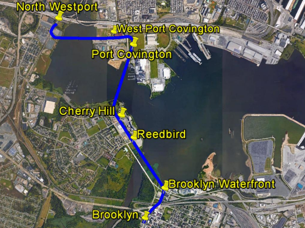
Now that the Port Covington deal seems to be done, the post-game analysis has begun. The word most often used to describe the massive Under Armour/Sagamore development is "unprecedented". It clearly breaks the previous rules.
Most Baltimoreans want to know how the deal will affect the city's overall fiscal health and economic climate, while some are more concerned with specific job and housing opportunities for low income residents.
But to Corporate America, the question will be: Where can we find another deal like that?
While Port Covington is unique, there is another very large site nearby with the same critical geographic attributes, being in Baltimore but not of Baltimore. It's an isolated site of roughly 50 acres that could be called "Patapsco Hill".
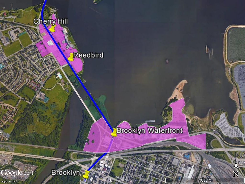
The Patapsco Hill site is roughly bounded by Patapsco Avenue to the north, the Patapsco River to the east, Southwest Park in Baltimore County to the south and the Central Light Rail Line to the west.
The city of Baltimore is often said to be "on" the Patapsco River, but really only a very small portion is - mainly Reedbird Park between Cherry Hill and Brooklyn. The Inner Harbor, Middle Branch, Northwest Branch and Outer Harbor are actually an estuary of the Chesapeake Bay.
Patapsco Hill is the only large developable land mass in the city that can accurately be described as being on the Patapsco River.
The site is currently being used as a truck and junk storage yard and was formerly a landfill, which accounts for its lofty ridge above the riverfront parkland to the south. In this age of "brownfields" remediation and "smart growth", and with the Patapsco Avenue light rail station located conveniently along its border, this site of about 50 acres is crying out for a better and more environmentally responsible use.
The river has most recently been known for the tragic and destructive flooding upstream in historic Ellicott City. Cleaning up Patapsco Hill for efficient high density development would be a great alternative to more flood-inducing suburban sprawl near the sources of the river watershed.
Patapsco Hill is as similar to Port Covington as is likely to be possible. It has a waterfront with boat access along the wide and wild portion of the Patapsco River, so it's kayak-ready. The 230 acre Southwest Park right at its doorstep can also provide many other recreation opportunities, yet is vast enough to swallow up a large population of users while retaining its rustic character.
With the adjacent light rail station already in place, there is easy access to downtown and even easier access to BWI-Marshall Airport. It's also close to the Harbor Tunnel Thruway (Interstate 895), although like Port Covington, a developer would probably ask for new and improved ramps. The adjacent portion of six-lane Patapsco Avenue is also extremely underutilized.
All the same hype as Port Covington about attracting the "millennial" generation could apply to Patapsco Hill, although they'd perhaps be a bit more suburban-oriented millennials. But even Port Covington's design combines urban and suburban trappings. We want it all: urban, suburban and back-to-nature.
The Patapsco Hill site is also extremely isolated, as demonstrated by the fact that no one ever seems to talk about it. While it is near the city neighborhoods of Cherry Hill and Brooklyn, the Baltimore County neighborhood of Baltimore Highlands and Anne Arundel County's Brooklyn Park, it has no access from any of them, being cut off by two railroad lines (one freight, one light rail) and the Patapsco River.
The fact that another site exists with such similar attributes to Port Covington also demonstrates that the city should not bargain from the presumption of scarcity. Baltimore is a very large city with lots of opportunities all around. The only scarcity is that each of us has only "one life to live" - to evoke a defunct soap opera. That's fitting, because the dealmaking in this city often resembles a soap opera with a new episode every day. There will be a new "search for tomorrow" and if the city is not prepared, all we can say is "now what?"
As such, the Port Covington deal has not prepared Baltimore for the next one. The project evidently exhausts the city's borrowing limit for Tax Increment Financing. There is no funding source for the new expressway ramps. The city still has a school aid shortfall. The next developer will still face the same angry crowds demanding more community benefit funds. And the real negotiation took place in secret, so we don't really know how it proceeded and what the city actually agreed to. One of the few things we can infer is that the vaunted "but for" rule has been thrown on the scrapheap of history.
The word "unprecedented" is fitting because with no guidelines, the next deal will be unprecedented too.
What the City needs even more than exciting new development opportunities is an economic climate which is conducive to such plans. Developers need to know what they will be facing, especially out-of-town developers who have no local political expertise but have access to a whole world of capital funding. Each new plan should demonstrate what is possible and thus pave the way for the next one.
The Patapsco Hill site is partially in Baltimore County and abuts Anne Arundel County, so it also calls for an even broader political consensus. The city should not act like we follow only our own rules without regard for the rest of the state or the increasingly global economic arena.
Or even worse, making up new rules as the game is played.
Most Baltimoreans want to know how the deal will affect the city's overall fiscal health and economic climate, while some are more concerned with specific job and housing opportunities for low income residents.
But to Corporate America, the question will be: Where can we find another deal like that?
While Port Covington is unique, there is another very large site nearby with the same critical geographic attributes, being in Baltimore but not of Baltimore. It's an isolated site of roughly 50 acres that could be called "Patapsco Hill".
 |
| Patapsco Hill development as it could be seen looking west from the Patapsco Avenue bridge over the Patapsco River. The tallest tower at left is shown at a height of about 400 feet - just because Google Earth can do it. |
Patapsco Hill
The city of Baltimore is often said to be "on" the Patapsco River, but really only a very small portion is - mainly Reedbird Park between Cherry Hill and Brooklyn. The Inner Harbor, Middle Branch, Northwest Branch and Outer Harbor are actually an estuary of the Chesapeake Bay.
Patapsco Hill is the only large developable land mass in the city that can accurately be described as being on the Patapsco River.
The site is currently being used as a truck and junk storage yard and was formerly a landfill, which accounts for its lofty ridge above the riverfront parkland to the south. In this age of "brownfields" remediation and "smart growth", and with the Patapsco Avenue light rail station located conveniently along its border, this site of about 50 acres is crying out for a better and more environmentally responsible use.
The river has most recently been known for the tragic and destructive flooding upstream in historic Ellicott City. Cleaning up Patapsco Hill for efficient high density development would be a great alternative to more flood-inducing suburban sprawl near the sources of the river watershed.
Patapsco Hill is as similar to Port Covington as is likely to be possible. It has a waterfront with boat access along the wide and wild portion of the Patapsco River, so it's kayak-ready. The 230 acre Southwest Park right at its doorstep can also provide many other recreation opportunities, yet is vast enough to swallow up a large population of users while retaining its rustic character.
With the adjacent light rail station already in place, there is easy access to downtown and even easier access to BWI-Marshall Airport. It's also close to the Harbor Tunnel Thruway (Interstate 895), although like Port Covington, a developer would probably ask for new and improved ramps. The adjacent portion of six-lane Patapsco Avenue is also extremely underutilized.
 |
| Patapsco Hill location - about two miles south of Port Covington. |
All the same hype as Port Covington about attracting the "millennial" generation could apply to Patapsco Hill, although they'd perhaps be a bit more suburban-oriented millennials. But even Port Covington's design combines urban and suburban trappings. We want it all: urban, suburban and back-to-nature.
The Patapsco Hill site is also extremely isolated, as demonstrated by the fact that no one ever seems to talk about it. While it is near the city neighborhoods of Cherry Hill and Brooklyn, the Baltimore County neighborhood of Baltimore Highlands and Anne Arundel County's Brooklyn Park, it has no access from any of them, being cut off by two railroad lines (one freight, one light rail) and the Patapsco River.
 |
| Patapsco Hill looking eastward along Patapsco Avenue, with its light rail station in the foreground. The Cherry Hill community is seen to the left behind the CSX freight railroad tracks. Brooklyn and Brooklyn Park communities are in the top background beyond the Patapsco River and I-895. |
Twice in a Lifetime Opportunity?
The fact that another site exists with such similar attributes to Port Covington also demonstrates that the city should not bargain from the presumption of scarcity. Baltimore is a very large city with lots of opportunities all around. The only scarcity is that each of us has only "one life to live" - to evoke a defunct soap opera. That's fitting, because the dealmaking in this city often resembles a soap opera with a new episode every day. There will be a new "search for tomorrow" and if the city is not prepared, all we can say is "now what?"
As such, the Port Covington deal has not prepared Baltimore for the next one. The project evidently exhausts the city's borrowing limit for Tax Increment Financing. There is no funding source for the new expressway ramps. The city still has a school aid shortfall. The next developer will still face the same angry crowds demanding more community benefit funds. And the real negotiation took place in secret, so we don't really know how it proceeded and what the city actually agreed to. One of the few things we can infer is that the vaunted "but for" rule has been thrown on the scrapheap of history.
The word "unprecedented" is fitting because with no guidelines, the next deal will be unprecedented too.
 |
| This distant northward view of Patapsco Hill from the Patapsco River shows the vastness of the adjacent 230 acre Southwest Park, and the relationship to the downtown skyline, barely seen on the distant horizon. To the right is the split of the Harbor Tunnel Thruway into two legs, toward I-97 to Annapolis and I-95 to Washington, DC. |
What the City needs even more than exciting new development opportunities is an economic climate which is conducive to such plans. Developers need to know what they will be facing, especially out-of-town developers who have no local political expertise but have access to a whole world of capital funding. Each new plan should demonstrate what is possible and thus pave the way for the next one.
The Patapsco Hill site is partially in Baltimore County and abuts Anne Arundel County, so it also calls for an even broader political consensus. The city should not act like we follow only our own rules without regard for the rest of the state or the increasingly global economic arena.
Or even worse, making up new rules as the game is played.
 |
| Patapsco Hill as seen looking northward from the Baltimore Highlands Light Rail Station through Southwest Park. |