March 21, 2016

Bayview Yard: A squandered plan for a MARC station

It's hard to believe this plan for a new East Baltimore MARC commuter rail station is what Johns Hopkins would actually want.

Railroad and transit stations are supposed to be at the central focal point of urban activities. But the proposed Bayview commuter rail station is hidden deep inside Norfolk Southern's freight rail yard, too far away from anything to benefit anyone.

It's all part of Baltimore's perverse pattern of doing everything possible to avoid transit-oriented development. Instead of creating sites for adjacent support development surrounded by access from communities throughout the east and northeast sections of the city, the station would be totally surrounded by freight trains that bang around to load and unload giant containers.

East Baltimore's proposed MARC commuter rail station would be located inside this Norfolk Southern freight yard
 accessible only by an overhead walkway and no regional rail line.
The Hopkins Bayview Research Park is about a half-mile south of here.

Johns Hopkins draws visitors, clients, customers and employees from a huge area from throughout Maryland's most populous corridor and Washington, DC. Hopkins has been doing everything in their considerable power to transform their world-class medical campus in East Baltimore into an "anchor institution" to transform the surrounding area in their image.

The government planners claim they're helping them, but this kind of help is worse than worthless,

The Bayview freight yard MARC Station plan is a vestige of the dead Red Line. The proposed station made little enough sense when it was attached only by an overhead walkway hundreds of feet long to the $3 Billion light rail line. It was also far enough beyond the Hopkins Bayview Research Park to send the line in the opposite direction from its original destination of Dundalk.

The Red Line died last year because even with its exorbitant price tag and poor performance, it didn't connect with Baltimore's "trunk" Metro line which serves the main Hopkins Hospital campus.

De-evolution of the 2002 plan to 2040


The original 2002 regional rail plan which included the Red Line looked innocuous enough when it was shown on its "cartoon" map along with lots of other rail lines and stations which made it look ostensibly like the DC Metro system. But reality has a way of setting in as years turn into decades of failure.

On the 2002 plan there were five new stations along the East Baltimore MARC line between Penn Station and the existing Martin/Middle River Station. That was part of a "mini-MARC" plan that was labeled "priority" in 2002, the same level of urgency given to the Red Line.

Fast forward to 2016. The latest reality is the Baltimore Metropolitan Council's new 2040 Transportation Plan. Those five stations have been whittled down to just the one - at Bayview Yard. Among the four that died was one on Broadway just north of the main Hopkins Hospital campus and their multi-billion dollar EBDI "Eager Park" community redevelopment project.

It was absurd from the outset that a commuter rail station would ever be built at that location, right between the tight Amtrak tunnel which connects to Penn Station to the west and a tight "S" curve to the east. For that matter, it was absurd that Amtrak, owner of the Northeast Corridor tracks, would ever approve five additional local commuter rail stops that would inevitably clog up their highly travelled operations all the way from Washington to Boston.

Doubly ironic is that while the latest 2040 plan reflects the fact that the Red Line to Bayview is dead, it revives the Metro extension north of Hopkins Hospital that the Maryland Transit Administration cancelled a few years ago due to lack of cost-effectiveness.

So the new BMC plan puts a commuter rail station at Bayview where there would be no regional rail service, and puts a regional rail line at Broadway where there would be no commuter rail service. What a pathetic joke!

The utter lack of cost-effectiveness is still plainly evident for all to see. The Metro extension proposed in 2002 was originally supposed to be 17 miles to White Marsh, to be completed by 2014. Then it was cut back to 3 miles to Morgan State University. Now it's only a single mile to be built by 2040 to North Avenue, at a cost of $1,692,000,000 - that's $1.7 Billion for 1.1 mile with two stations, all underground. And any extension beyond North Avenue would also be underground, so it would be just as absurdly expensive. That is the epitome of cost-ineffectiveness!

This BMC plan is just dripping with frustration. The planners lost their the 14 mile $3 billion Red Line, so their apparent revenge is to propose a one-mile $1.7 billion plan by 2040 to replace it. It's a kind of hypothetical sabotage. Shrink fourteen miles to one mile... that'll show 'em!

A simple, effective and far better plan


OK, enough of these childish games. None of us will be children anymore by 2040. Let's develop a plan that actually makes sense.

There's an ideal site for an East Baltimore MARC Station on 20-plus open acres at Edison Highway just north of Monument Street, half way between the Hopkins main campus and Bayview research campus, with excellent access to the surrounding communities throughout east and northeast Baltimore.

It's also located along the ideal corridor for a cost-effective Metro extension that would come up out of the ground at the first opportunity, minimizing the expensive tunneling which killed the Red Line and would even more inevitably kill the Metro extension under Broadway contained in the 2040 plan. Unlike the Red Line, such a Metro extension would be fully integrated into the MARC station, a local bus hub, and transit-oriented development, somewhat like a Baltimore version of the DC Metro's New Carrollton hub, only better.

"Health Corridor" Metro Extension - connecting Hopkins Hospital's main campus with Station East,
 an Edison Highway MARC Station and the Hopkins Bayview campus.

The MARC Station would be just a short hop on the Metro from the main Hopkins Hospital campus, from the Bayview campus and from the new "Station East" community. Just as importantly, all these stations would also be linked to each other.

And since the Metro would be out of the ground it could then be further expanded to White Marsh, Middle River, Essex and Dundalk with no more prohibitively expensive tunneling.

A Hopkins "Health Corridor"


Such a plan would essentially create a new Johns Hopkins "Health Corridor" which extends all the way from the main hospital campus to Bayview. It would be the ultimate completing step to the Hopkins vision for the area surrounding their main campus, but without the destruction and displacement which has already been carried out so painfully and expensively over the past decade.

Site of proposed East MARC Station under Edison Highway, looking west toward Hopkins Hospital campus.
The Station East neighborhood is in the background in front of the tall buildings.

The growth being stimulated by Hopkins already support such a plan. The first new neighborhood initiative beyond EBDI "Eager Park" is already in place - "Station East". This neighborhood just to the east, where newly renovated houses now stand next to where recently stood some of the city's most serious devastation, was named after a station that doesn't even exist yet, and isn't in the BMC 2040 plan.

But the station at "Station East" would easily be provided along an eastern Metro extension. It could be a cost-effective "cut and cover" station built into the tunnel portal instead of buried deep in the ground as the proposed stations under Broadway would have to be. This station would also support the greater Berea area to the north.

This redevelopment has already started in a responsible way, not like the wholesale destruction which occurred north of Hopkins Hospital.

Looking east from MARC Station site under Edison Highway at part of the adjacent large vacant development parcel,
 with Hopkins Bayview Research Park in background. The Metro would go between them.

Just to the east along Edison Highway is where the MARC commuter rail station would be integrated with a Metro station to serve all of northeast Baltimore, northward throughout the Belair Road corridor, as well as southeastward to Highlandtown, Patterson Park and Canton. None of this is accessible at the proposed Bayview freight yard site. A Bayview Yard MARC station site wouldn't even be easily accessible form the Hopkins Bayview Research Park.

On the other hand, the Metro could easily provide a station built into the berm between Bayview and the Harbor Tunnel Thruway (Interstate 895), easily accessible by pedestrians from all of Bayview as well as Greektown. The MARC station, Hopkins Hospital and the rest of the Hopkins Health Corridor, as well as downtown would then be a very short Metro ride from Bayview.

In sum


The BMC 2040 plan wants to spend $1.7 billion for a tiny one-mile Metro extension that doesn't even serve MARC. The plan also creates a MARC station that doesn't even serve the Metro, or much of anything else. Both Johns Hopkins and all the rest of east and northeast Baltimore would be the big losers.

It's time to stamp out such small thinking and create an integrated MARC and Metro plan that actually works.

March 3, 2016

Red and Purple Line partnerships and political football

It's fitting that Joe Flacco signed the richest contract in pro football history on the same day the state of Maryland finalized the biggest contract in its government history - to build the light rail Purple Line. And while nobody is arguing that Flacco is anywhere near the best player or quarterback in the NFL, neither has anyone claimed the Purple Line, whose giant consortium won the $5.6 Billion competition, is more valuable than the Metro transit lines it links in the Washington metropolitan area.

It's all about what needs to be done, how to do it, and who can actually do the job.

The DC area Purple Line left the Baltimore Red Line in the dust, just as the Washington Redskins surpassed the previously mighty Baltimore Ravens last year on the strength of backup quarterback Kirk Cousins, when both teams' highly paid starters, fallen Flacco and fragile Robert Griffin, were left on the sidelines.

While $5.6 Billion is a staggering commitment, it's hard to ascertain just how much money it really is or how it was calculated. The purpose of the public-private partnership is to spread out the risk and acquire the expertise that the state is unable or unwilling to summon on its own. It's sort of like renting instead of owning. The landlord is just more prepared to deal with the property and its complexities which are inherent in a deal as encompassing as this.

But as complex as the Purple Line's 36-year design, finance, construction and operating contract necessarily had to be, it would have been a mere napkin note compared with how complex and convoluted a comparable Red Line public-private partnership would have been.

There's really only one solution: The Red Line must be downsized into a manageable project, to get it going again.

The most important part of the Red Line is economic development, not just transit, as shown in this alteration
 of the MTA Harlem Park station plan to get rid of the adjacent "Highway to Nowhere". (by Marc Szarkowski)

Taking the vertical game underground


The proposed Red Line's huge risk and complexity was mostly in its 3.4 mile Red Line tunnel under downtown Baltimore, which represented roughly half of the total $3 Billion capital cost and two-thirds of the heavy construction cost of the entire project.

But that was just the beginning. The "vertical game" (to stay with football parlance) refers to far more than just whether to try to go underground in a tunnel to get the Red Line through downtown, which Maryland Transportation Secretary Pete Rahn rightly called a "fatal flaw" in the project. After all, there are many subways in the world.

But then the Maryland Transit Administration decided it had to award the engineering contracts and begin final design for this tunnel before any kind of public-private partnership was established. The Red Line process had been plodding along for over a decade and the MTA felt the need to just keep plunging forward. They knew that engineering the tunnel would take far longer than any other part of the project, while its construction would have to begin first. If they didn't begin the tunnel's engineering as soon as possible, the entire project would suffer from insurmountable delays, And of course, time is money.

So while the Red Line's timetable was behind the Purple Line's in most respects, it was ahead of the Purple Line's in design. Even now, engineering on the Purple Line still hasn't begun.

This is actually a huge advantage for the Purple Line, enabling its public-private partnership to be defined and negotiated far more cleanly and flexibly. In contrast, Red Line engineering was literally stuck in a hole.

This explains much of the reasoning behind the MTA's now infamous "all or nothing" approach to the Red Line. The tunnel needed its own commitment and timeline as a prerequisite for anything else. So now all that expense is literally buried in the ground. "All or nothing" became nothing.

The only flexibility would have come if an entire piece of the project was jettisoned, when and if money needed to be saved. That probably would have meant chopping off the transit line's east or west ends, which were the segments that actually contributed to the line's ridership in a reasonably cost-effective way.

That is what Baltimore County Executive Kevin Kamenetz was rightly fearful of. He had been pressured by the state into making a financial commitment to the project with no genuine assurance that the portion of the project in his jurisdiction would actually get built.

It's like football fans who now worry about whether the Ravens can now actually afford to pay for a good defense and offensive line to support the rich Joe Flacco. But offensive lineman, even great ones like Marshall Yanda, cost a lot less than Flacco, so it makes a lot more sense to pay them their due than to cut them just to throw more money at Flacco.

The Red Line tunnel as designed would have been a mandatory and largely inflexible expense. Its only severable element would have been its pedestrian tunnel to connect the Inner Harbor Red Line Station to the Charles Center Metro Station. Red Line supporters claimed that this pedestrian tunnel was crucial, steadfastly defending it to the critics who mocked and criticized it. But should the thousands of projected daily Red Line transfer riders be forced to walk the length of more than TWO football fields to get from one line to the other? Even mighty Joe Flacco never had to do that.

But here's a hint: The extremely detailed 65% complete engineering drawings for the Red Line's tunnel showed only an outline of this pedestrian tunnel. That's expendability. Like a quarterback taking a sack to avoid a fumble.

The blame game


Like pro football, running a transit system is really all about management, and there's where the $3 Billion Red Line was truly unworkable.

The Baltimore Ravens actually originated with the State of Maryland. The state wooed the Browns away from Cleveland (that's nasty!) and built them a new stadium, which the state still owns. But the state has nothing to do with anything else about the Ravens, even how much Joe Flacco is paid.

That's the way it's going to be with the Purple Line too. The $5.6 Billion private partner will fully design, finance, build and operate the line. The buck stops there.

That kind of direct accountability would not have been possible with the Red Line. Besides the cloudy design decisions discussed above, there is the question of actually operating the line after it is completed.

The vehicles would be owned and maintained by the private consortium. But the state MTA would actually run the trains, just as with their other heavy and light rail lines and buses. This is a recipe for perpetual finger-pointing. Whenever a service problem arose, the state would blame the contractor and the contractor would blame the state. The state would try to get the contractor to fix any faults with the vehicles, and the contractor would blame MTA train operators for abusing the vehicles they're responsible for maintaining.

Trains running late could be an even bigger issue in the blame game, and poor "bottom line" ridership would be the ultimate unresolvable issue.

Yes, contract language would attempt to clarify these kinds of things, but that just opens doors for lawyers. The example the MTA has cited is that there would be contract criteria for cleanliness of the vehicles, and if they flunk the "white glove" test, the contractor would forfeit some of the state's money. But gum under the seats is far from being the most serious problem with operating a transit line. Gumming up the motors is a far greater threat.

Horizontal vs. vertical monopoly


This is all part of the question confronted by economists of horizontal vs. vertical monopolies. All transit lines exhibit monopoly characteristics, which means that a free supply/demand market is not possible to regulate or resolve them.

The DC-suburban Purple Line will be a vertical monopoly. All stages of the "supply chain" which delivers transit service will be clearly controlled by the consortium.

Vertical monopolies are strong in that management and production are controlled holistically. The operator follows orders, merely doing what it's mission says it will do. Any influence from politicians, workers, riders, etc. can be processed by the entire system. Of course, pure vertical monopolies are rare. (It would be like the National Football League owning college football.)

On the other hand, Baltimore's mass transit system is a horizontal monopoly, which means it is vulnerable to impacts on all flanks from all forces and institutions. The transit operators union has its say. The various jurisdictions have their say. The state legislature has its say, etc.

A horizontal monopoly is always in a state of flux. The latest is a proposed "scoring system" by the Maryland legislature to determine which transportation projects get built. President Obama already implemented something of that sort when he had the Federal Transit Administration incorporate community impact factors into its selection criteria for transit project funding.

Then there is the effect of separate local transit systems. The DC metropolitan area is far ahead of Baltimore in this, but Baltimore is catching up. The city now has its Charm City Circulator system which affects the MTA tremendously, although they haven't admitted it. The Uber-style cyber-taxi system is becoming a huge factor in transit and perhaps Zipcar renting will as well.

Bottom line: Downsize the Red Line


The hype called the Red Line a "game changer". But the truth is that the game is always changing faster than we realize until after the fact. A single poorly designed rail transit line is but one cog in the wheel of change.

The biggest question in any public-private partnership is: What happens if it fails? In the vertical monopoly Purple Line, it's the relatively simple matter of finding a way to adjust the game to achieve the desired results. That customarily means shoveling more money at the problem, but at least it's do-able.

The Baltimore MTA has been shoveling money at its problems for decades, with a spectacular lack of success. All kinds of solutions have been proposed, as if some knight in shining armour such as moving to an all-powerful regional authority could fix the problems. But it just doesn't work that way.

The goals are nebulous enough as it is. What Baltimore really wants is to make transit a potent economic development tool. How do we measure that?

There is really only one feasible direction we can go. The Red Line must be downsized and refocused into the smallest feasible project which is capable of moving the city and region toward its goals, while accommodating future expandability to continue expanding those goals.

At the very least, that means building a Red Line which emphasizes linkage with the rest of the transit system and with community development. That means getting rid of the 3.4 mile downtown tunnel.

It means a clearer and more straightforward public-private partnership. It probably means getting rid of the local government funding shares, which was so unpopular it devolved into smoke and mirrors. Local money should be directed instead to related station-area community projects.

This certainly means the Red Line won't be built immediately (we already knew that) so the preparation of the line's corridor for the future can and should proceed first. That could mean getting rid of the "Highway to Nowhere" and creating a viable corridor development plan which includes the re-use of the massive Metro West former Social Security complex.

A multi-billion dollar public-private transit partnership is complex, but redeveloping a city is far more important and rewarding.

February 24, 2016

Carroll Park: A golf course for Under Armour

Under Armour is making plans for virtually every major sport at its new Port Covington corporate campus - except golf. But to compete, Under Armour needs golf - the sport of maximum mental dexterity and optimum demographics, played by many of society's top achievers. Golf is the sport where power players bond while making multi-million dollar business deals. 

Inner city golf courses in dense old cities are rare, but there just happens to be one waiting for Under Armour less than two miles away from its new Port Covington home.
Carroll Park golf course with the gigantic Montgomery Park office building in the background.
The course needs some landscape screening from its industrial neighbor and its sand traps are more like mud puddles, but the potential is all there.

Yes, Baltimore has the Carroll Park municipal golf course, and it's waiting to share in Under Armour's urban renaissance. Its fantastic location is part of the city's most historic park, Carroll Park. It sits right next to the city's largest office building, the fully rehabbed 1.3 million square foot Montgomery Park. The setting does have a few urban interruptions and typical Baltimore squalor, but is mostly as bucolic and peaceful as one could imagine - something that could not be created from scratch for any amount of money.

Along with the even closer Westport neighborhood, which Under Armour's Kevin Plank has also bought into with its large waterfront property, the Carroll Park golf course is a key link to making the Port Covington development work for all of West Baltimore.

History of Carroll Park and it's golf course


The key to turning around the golf course's not-so stellar image is to create a strong linkage to the rest of Carroll Park and to southwest Baltimore as a whole, something which has never actually been done in the park's entire history spanning parts of four centuries.

In the 18th century, Carroll Park was the country estate of the Mount Clare mansion, Baltimore's oldest and most historic free-standing house, which still sits just across what is now Monroe Street from the golf course. Then in the early 19th century, America's first railroad was built along what became the north barrier of the estate and later the park. Subsequently, a through railroad connection was built right through the estate, which cut off what is now the golf course - a barrier which exists to this very day. The early 20th century Olmsted park plan called for building an underpass under this railroad track, but this was never done.

Finally in the 1920s, a large swath of the park was sold to Montgomery Ward to build its massive retail distribution facility and department store. The golf course was developed at about the same time, so it never had the park connection it needed.

The golf course suffered other major indignities. Blacks were long barred from playing there. Interstate 95 was built along the otherwise scenic Gwynns Falls valley and the golf course's Washington Boulevard entrance on its western flank. Just in the last several years, the city and state came up with a half-baked plan for a truck terminal along the railroad tracks which would have solidified the barrier and increased its disruption. Despite that plan having been killed, the Southwest Partnership is still promoting the construction of a large security wall in a futile and misguided attempt to further cut off the north side of the park from the adjacent struggling neighborhoods.

Unifying the golf course and the park


There is currently no legitimate way to get to the golf course from the main part of Carroll Park or the surrounding communities. The parkland has become an overgrown impenetrable jungle, allowed to persist because of the active freight railroad which prevents passage anyway.

The rail underpass in the hundred year old Olmsted park plan still needs to be built. This could be used to transform the adjacent park area off Monroe Street into the main entrance to the golf course and to create important linkages to the historic park, the urban communities and ultimately to Westport, Port Covington and the Under Armour campus.

Proposed Carroll Park Golf Course Clubhouse near Monroe Street - incorporating an entrance under the CSX railroad track
 to link the course to the remainder of Carroll Park - as envisioned by Marc Szarkowski.

To give the golf course a real urban presence and identity, a new clubhouse should be built at this location, just north of the huge Montgomery Park building on Monroe Street. A design such as Mac Szarkowski's illustrated here would befit Under Armour's support for golf in a struggling inner city community and in the city's most historic corridor.

The "Under Armour Performance Golf Clubhouse" has a nice resonance to it, doesn't it? A nice place for a retreat or a power lunch away from the office.

Golf course view from the proposed Clubhouse location in Carroll Park near Monroe Street.
 The nine holes could be renumbered to put Hole #1 and Hole #9 right here.

The Port Covington connection


Until the 1980s, Port Covington was the harborside rail yard at the terminus of the Western Maryland railroad, which became expendable after CSX bought it out.

Now the massive size of the 13 million square foot Under Armour plan for Port Covington calls for an emphasis on mass transit to provide the necessary access. Too much development is planned to allow automobiles to be the predominate mode of access. The plan calls for a new rail transit spur to the existing Central Light Rail Line which serves Downtown, Westport, BWI-Marshall Airport, Hunt Valley and other points in between.

Relationship of Port Covington to the Inner Harbor, Carroll Park and the Central Light Rail Line in blue.
A proposed light rail spur is shown in orange, which could be continued westward in the Monroe Street corridor to Carroll Park and the golf course,
then along the B&O Railroad Mount Clare corridor back to downtown, creating great redevelopment opportunities for Southwest Baltimore.

This plan could easily be expanded to serve the old Western Maryland corridor to Carroll Park and the golf course. Port Covington denizens could easily hop on a train for a two-mile ride to the golf course to play a quick nine-holes in the middle of their ambitious 14 hour work day (work hard, play hard!) And Carroll Park is only a nine-hole course anyway.

West of Westport, since the old Western Maryland track is still being used by CSX freight trains, the rail transit line would be much more feasibly be built to streetcar standards on Monroe Street.

This line would be part of a whole new compatible streetcar system, optimized for shorter trips and designed so that the same rail vehicles could be used on-street or off-street. The system would serve a new dispersed crosstown urban development pattern away from downtown, of which Port Covington is the leading example. A downsized Red Line would be the trunk line and prototype for this new integrated rail system.

There are special opportunities for streetcars in the Carroll Park area. Monroe Street is adjacent to the MTA's historic streetcar barn (now used for buses), part of which could easily be reverted back to a streetcar storage and maintenance facility as well as a museum. Thus, modern and vintage streetcars could share the same tracks.

The vintage streetcars could travel from the historic streetcar barn around Carroll Park to the "First Mile" Mount Clare B&O Railroad corridor and then to the B&O Railroad Museum, and thus be an integral part of its story of American railroading. The modern streetcars could proceed in a larger crosstown arc to the Inner Harbor or the Lexington Market transit hub which it would share with the revised and downsized Red Line.

Southwest spin-off development


With these connections, Port Covington is poised to encourage west-side spin-off development in a way that the waterfront development on the east-side cannot do. On the east side, Harbor East and Harbor Point were last steps after redevelopment of the Fells Point and Canton waterfront. Similarly on the South Baltimore peninsula, Port Covington is a last step after Federal Hill, Locust Point and Riverside. All this has come largely at the expense of the west side, as the city's economic energy has gravitated toward the waterfront. But a last step for South Baltimore's redevelopment can become a first step for West Baltimore.

Southwest Baltimore can be the yang to Port Covington's yin. Since Under Armour's Port Covington will exude nonstop newness, an adjacent area steeped in history will be a welcome contrast.

Six mile greenway loop for walking, running or cycling through historic West Baltimore from Carroll Park
 and its golf course in blue) around to the Gwynns Falls Valley (in green) and Downtown (in purple).

But while the new and old would be the complementary contrasting themes, a commitment to active recreation would be the overarching common theme.

The unifying element in West Baltimore would be a six-mile greenway loop. It would share much of the right-of-way of the proposed streetcar line in the B&O Railroad "First Mile" corridor, as well as the Red Line right-of-way in the "Highway to Nowhere" corridor, with many opportunities for transit oriented development.

This greenway loop would do for West Baltimore what the proposed waterfront promenade would do for Port Covington, each taking maximum advantage of its attributes - new waterfront development in Port Covington and two and a half centuries of history in West Baltimore.

In sum, Under Armour's Port Covington would be positioned not merely as the southern tip of the South Baltimore peninsula but as an anchor for the revitalization of West Baltimore. And golf at the Carroll Park course would be the attraction that leads the way.

February 10, 2016

MagLev for the Masses! ----- (5 basic rules)

Sorry - no spiffy futuristic pictures of MagLev trains in this article. Nobody knows what an American Magnetic Levitation system would look like yet. The whole point is that America offers a clean slate to reinvent high speed rail for the 21st century, without having to conform to expectations.

So the $28 million federal grant which the state recently received to study a MagLev line between Baltimore and Washington is very welcome. Throw away the preconceptions and open your mind. Don't make the same mistakes as China or Germany or the Maryland Transit Administration's 1990s study, and don't make new mistakes overreacting to the old ones.

Don't construe MagLev as a threat to Amtrak in the Northeast U.S. Corridor. No matter what happens, that line needs billions in improvements, and sooner rather than later.

But a fifteen minute ride at up to 300 mph from Baltimore to Washington, part of the world's most powerful urban corridor, would certainly be a "game changer" - that often abused term would certainly apply. So let's REALLY change the game.

A MagLev alignment in the I-95 corridor?

Five Basic Guidelines:


1 - Connecting to BWI-M Airport should not be a "given" - Airports are soooo 20th century! What's the point in getting to the airport in ten minutes so you can wait an hour in a security line? And how often do most people fly anyway? The purpose of MagLev should be to reinvent inter-urban travel, not to enable slightly quicker trips to Dubai, LA or Tokyo for which there's no competition anyway. In the 1990s study, this became a trap where the whole MagLev line became narrowly focused on affluent expense-accounted business travelers - an Amtrak Acela on steroids or a short-hop Concorde.

The airport area is devoted to supporting air travel, not overall urban activity like housing and jobs. Besides, linking to BWI-M would not be easy. There is no suitable right of way, and the cost and impact of tunneling is what killed the 1990s MagLev study, politically and otherwise.

2 - Don't assume maximum tunneling - After the 1990s MTA MagLev debacle, it's easy to just throw up our hands and say the whole thing needs to be all tunneled. Out of sight, out of mind. The 1990s study attempted to use an aerial alignment within the Interstate 95 corridor, but the deviations to serve the airport made it not worth the trouble, in cost, impact or in the extra travel time to slow down for the curves.

I-95 is straight and wide enough that an elevated line designed for sufficiently high speeds is possible, at a fraction of the cost of tunneling. And wouldn't it be cool to look out through your windshield and see MagLev trains whizzing by above you as you drive? Or look down from the MagLev above and see those old-school motorists like they're standing still? Both groups would then instantly know their place in the new travel paradigm.

It may not be as cool as the now-classic MagLev scene with Mount Fuji in the background, but BaltWash megalopolitans will identify with it.

3 - Plan for a whole new kind of "transit oriented development" -  For an intermediate station between the two cities, all previous rules and expectations should be thrown to the wind. What kind of community would grow up around the station for a 300 mph transit line that could whisk you to Baltimore or Washington in less than ten minutes, and ultimately to New York in well under an hour? Who knows??? The only thing we do know is that it would be unlike any community that has ever existed before, and that it would not look like a 20th century airport. And since it would be unique, it would be extremely valuable for living, working and visiting.

The station should probably be built on a simple platform over Interstate 95 with provisions for adjacent high density "air rights" development - possibly located next to the Konterra office park near Laurel or perhaps next to the UMBC research campus in Baltimore County, especially if access to BWI-M airport is still considered a priority. Or maybe both.

The station areas in Downtown Baltimore and Washington would also be profoundly affected, with the additional factor that unlike suburbia, our cities are the accumulations of all our past history and culture and continuing evolutions.

4 - Plan for convergent technologies that take advantage of MagLev's unique characteristics - The digital revolution is not just one invention with one technology. It has had profound spin-offs that affect everything from telecommunications to controlling "the internet of things". The two fundamental transportation differences involved with MagLev are: (1) The propulsion is in the guideway, not the vehicles, and (2) All systems must be automated to work in a coordinated manner.

These differences should cause secondary revolutions. All the old rules about driver reactions and vehicle spacings will be gone. Pre-determined schedules will be irrelevant and vehicles can be dispatched in real-time based solely on travel demand at any given moment. Trains would no longer have to be a certain length and size to achieve economies of scale, and could consist of smaller single driverless vehicles. Many of the ramifications of driverless automobiles currently being studied would apply more and sooner with MagLev. Stations and guideways could then be appropriately downsized as well, resulting in less cost and impact.

5 - Maximize expansion capacity! - This is the transportation revolution for the 21st century. All aspects of it should be optimized to allow maximum capacity expansion. All stations should have bypass tracks so that vehicles only need to stop as necessary, and vehicles can be readily brought on and off line as needed. The guideway should be designed as a "trunk line" with provisions for future branch lines to Columbia or Annapolis or wherever.

MagLev for the Masses!


In sum, MagLev should be planned and designed for the masses. Automobile and air travel were once the exclusive province for the rich, but inevitably they got to the mass market. Computers were once klunky things that cost many thousands of dollars. Now they're far more powerful and we put them in our pockets.

If anyone should have seen this, it was China with its billion-plus population, but they made the mistake of orienting their MagLev line to Shanghai Airport. What percentage of Chinese are air travellers? Not much.

Of course, it is America, not China, that's known for its freedom, innovation and personal upward mobility. Europe and Japan are known for their conventional high speed rail which has become part of their highly organized lifestyles. But America is now a blank slate for high speed transportation. That's why world investors and capital are becoming attracted to America for MagLev. Americans should be ready for anything.

February 3, 2016

Metro West speculation on the "Highway to Nowhere"

It's gratifying that the federal government was able to attract bids from reputable developers to buy its vacant former Social Security Administration Metro West complex at the west downtown end of the "Highway to Nowhere".

But it's obvious that the bids, which topped out at $7.1 million, are based purely on speculative value. With 1.1 million square feet of office space, that comes out to less than $6.50 per square foot. (Note: That's equivalent to $13,000 to buy a 2000 square foot  house - you could spend that much just for new floors.) And with about 12 acres over roughly 6 square blocks, there's enough land for much more development than that.

The top offer from Caves Valley Partners is based instead on their anticipation of how much concession of development incentives, tax breaks and infrastructure they might be able to cajole out of the public sector to make any redevelopment happen.

Seldom scene - The view from the westbound "Highway to Nowhere"  looking back eastward
 at the huge Metro West complex, which the eastbound highway splits in two.
This view is dominated by part of the site's vast open space which is landlocked in the middle of the highway. 

Also part of this speculation is how the city's real estate climate will be affected by all the developer deals the city has been making elsewhere, with Kevin Plank in Port Covington and Westport, plus Harbor East, Harbor Point, Canton Crossing, Old Town, State Center, La Cite in Poppleton, and the list goes on...

The city has been giving top dollar subsidies to the very best waterfront development sites, so that makes all the less desirable sites all that much less attractive and valuable. At Harbor Point, the city even gave big subsides to Exelon Corporation to locate there, when they already had to locate in the city by law. And this was after the city's politically powerful Downtown Partnership had already opposed the deal.

It's about as opaque and lumpy an economic "playing field" as one could imagine, with political acumen counting for much more than development acumen.

So it's not real value. Baltimore's real estate market is too dysfunctional for that. The recently concluded "auction" is actually the second attempt for the property, the first one ending with no winning bid.

This auction should also conclude with no winner. Instead, the city or state government should move in and acquire the land in accordance with federal procedures, so that the public sector can decide what investment is in the public's best interests, since the tax breaks and infrastructure will no doubt be financed with public money anyway.

At that point, a true developer solicitation can take place, based on real value, not speculative value.

But the public sector must decide what that real value can be. The nearby impoverished West Baltimore neighborhoods urgently need real help and a real connection to the economic energy of downtown. The issues are too large to leave it to a developer to set the agenda.

Inaction so far


The adjacent University of Maryland has rejected the site, instead proceeding with their ambitious building program elsewhere within their campus and neighborhoods.

The city and state have spent the past fifteen years analyzing the area with regard to the now-rejected $3 Billion Red Line light rail project. Their final plan failed to serve this site or the rest of the university campus. For various defunct reasons, the alignment and stations were located elsewhere.

Also, as part of that long process, the city steadfastly maintained that the "Highway to Nowhere" should stay. This highway splits the site, going right through a hole in the buildings. The city maintained this stance despite the fact that the state closed the highway for months to do prep work for the Red Line by demolishing a huge retaining wall at the west end of the highway, with minimal adverse impact on traffic patterns.

Metro West in the background from the vast landlocked wasteland inside the "Highway to Nowhere",
as seen from near where Fremont Avenue once was. 

The $3 Billion Red Line is now dead, so that a smaller and more viable Red Line plan can now be developed in its place, with more focus on supporting true transit-oriented development. As part of this plan, one or more stations can now be placed adjacent to or even inside the Metro West property.

The state's huge State Center government office redevelopment program, also over a decade old, is also in limbo. It may be seen that Metro West is a better location for some of this office space than State Center.

Planning questions to be answered


The Metro West site has terrific development potential, but it is far too hazy at this point. The property should be secured by the public sector, then the important planning decisions should be made:

Get rid of the "Highway to Nowhere"?

Build a viable downsized Red Line?

Develop a linear park in the Martin Luther King Boulevard corridor?

Create a traffic conflict-free development and greenway plan inside the Highway to Nowhere ditch?

Rehabilitate Upton, Lafayette Square and Harlem Park?

Expand the Heritage Crossing neighborhood?

Create an actually viable State Center plan?

Create an actually viable Lexington Market/Howard Street area plan?

More ideas?

January 20, 2016

Unify city and Port Covington: Put a fork in Hanover St.

Sagamore Development Company's giant 13 million square foot plan calls for changing almost everything in Port Covington. But some things are more changeable than others. And since change is expensive, the plan should be selective in what is changed - to invest its precious Tax Increment Financing and other infrastructure dollars wisely.

Hanover Street is the key to integrating Port Covington and old South Baltimore. Simply making Hanover Street work should enable the whole street plan to work.

Hanover Street looking south from old South Baltimore toward the I-95 overpass.
The houses have been nicely rehabbed with a brand new median strip to soften the traffic impact.
This is the primary gateway to Port Covington from the urban grid, but should not bear the brunt of thru traffic.

The Sagamore plan is to be commended for going to great lengths to try to enhance the linkage between South Baltimore and Port Covington. It does this by proposing to eliminate the I-95 exit ramp to Hanover, by extending Light Street southward over the railroad tracks and under I-95, and even by lowering Hanover Street itself to make it part of the new development.

But all of these things would be very difficult and expensive to do, and would probably have major extraneous effects which have not yet been revealed or discussed.

While there is no doubt that a 13 million square foot development is a very large omelet that will require breaking some big eggs, some eggs may be too tough to crack. Hanover Street is the egg that can be cracked with a fork. A fork in the road, that is.

Gigantic Port Covington will need all the access it can get from Interstate 95, and the nation's biggest highway may be the one piece of infrastructure that can't be tampered with to suit Sagamore. And in any event, the current ramp system actually works well, providing all the necessary connections in three directions - both north and south, to and from I-95, and also to and from downtown on I-395.

In fact, it's not the ramp system's connections to and from the Interstate highways that are the problem. It's the opposite ends of these ramp connections into Port Covington that are problematic. Which is actually fortunate, because Sagamore and the city have a lot more control over what happens in Port Covington than on I-95.

Moreover, the goals are not mutually exclusive: If the best possible access is provided at the least cost and disruption, Port Covington can be made a relatively seamless part of the city as a whole.

Hanover Street has already been bent around Otterbein


The small but elegant Otterbein neighborhood is at the opposite north end of the South Baltimore peninsula from Port Covington, and achieved comparable objectives when Hanover Street's traffic pattern was realigned there in the late 1970s.

The Otterbein neighborhood had been condemned and slated for destruction to build Interstate 395 into downtown. But a revised plan saved it, which led to it becoming perhaps the premiere rowhouse neighborhood in all of Baltimore. It also created a site for the convention center.

As part of its renewal, Hanover Street was closed through Otterbein, and it's traffic bent around it in a slalom to Charles and Light Street to serve downtown and the Inner Harbor. Then when I-395 and Conway Street were completed, much of the through traffic shifted away from Hanover to the expressways. That traffic reduction enabled the city to remove Hanover Street's peak period parking restrictions. It took a while for housing renewal on Hanover Street to catch up with the surrounding more local streets, but eventually its houses were rehabbed as well.

So now Hanover Street is poised to be the primary urban grid linkage between South Baltimore and Port Covington. The only problems are that Hanover Street in Port Covington is oriented far more to the I-95 ramps and to the bridge to the south toward suburban Ritchie Highway than it is to the huge future development. This results in a hostile anti-urban environment on Hanover Street, accentuated by its huge and complex intersections with McComas Street and Cromwell Boulevard, along with the ramp and "jughandle" traffic merging and diverging into the flow.

All roads lead to Port Covington


Hanover Street's problems are local, so the solution should be local.

Cromwell Boulevard, built as the spine road for the first wave of Port Covington development in the 1980s (which ended up only being the Sun printing plant), is actually much better suited to handle the through traffic than Hanover Street.

In fact, Cromwell is not very well suited to be an urban street of the type Sagamore is trying to cultivate in its plan. Instead, it serves as more of an edge, adjacent to the Locke Insulator plant and the Gould Street power station, and as an access road for the development in between which will be oriented to the waterfront.

The Sagamore plan gets rid of the eastern portion of Cromwell toward McComas Street and I-95, but this seems wasteful and unnecessary. 

Instead, Cromwell Boulevard should essentially replace Hanover Street as the through traffic spine between the Hanover Street Bridge and northward to I-95, Key Highway, the port and downtown.

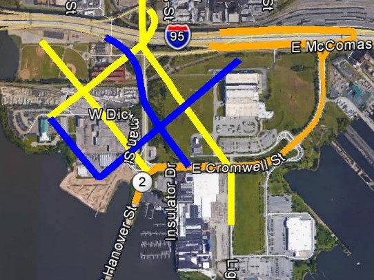
A better street plan: Get rid of Hanover Street between McComas and Cromwell.
Connect Cromwell (orange) directly from the Hanover Street Bridge (at bottom) to I-95 ramps (at right).
Create a street grid connecting northward to Hanover Street and its I-95 on-ramp (top yellow) and its I-95 off-ramp (blue).

Here's the key: The intersection of Cromwell and Hanover should be modified so that Cromwell connects directly to the Hanover Street bridge to the south. In turn, the intersection of Cromwell and McComas Street should be modified to facilitate access to I-95. This was the original concept back in the 1980s, but it was deemed too expensive to modify McComas Street underneath I-95 to make the ramp connections work.

But the much larger Sagamore development plan raises the ante, and proposes far more expensive changes than any of this.

Making the intersection of Cromwell / McComas / I-95 work this way would divert through traffic away from the intersection of Hanover / McComas / I-95, and allow that critical area to be oriented almost entirely to local and I-95 traffic only, and thus to integrating Hanover Street between Port Covington and old South Baltimore.

The Sagamore plan attempts to soften that intersection by getting rid of the I-95 off-ramp and lowering Hanover Street, which would have far more widespread impacts and be far more expensive. Instead, Hanover Street could be modified as follows:

1 - Orient the I-95 ramps directly into new Port Covington streets. Since the ramps link to Hanover on diagonals, these streets could be oriented to similar angles: The I-95 off-ramp merges with Hanover at angle which points to the southeast, so it could be oriented to a new street at a similar southeast angle proceeding in a straight shot into Port Covington. 

2 - Similarly, the on-ramp onto I-95 from Hanover is oriented from the southwest, so a new street could be similarly oriented from this point to the southwest.

3 - The angles between these two streets could be used to define an entire street grid for the new development.

4 - McComas Street to the east of Hanover would become an unnecessary complication to this street grid and could be eliminated, or localized to better serve the proposed athletic facilities in the catacombs under I-95. Eliminating McComas would be particularly beneficial at Cromwell because it would eliminate the weave from the I-95 off-ramp onto Cromwell, which is currently not allowed.

5 - Similarly, existing Hanover Street to the south toward Cromwell Boulevard and the bridge over Middle Branch would also be an unnecessary complication and could be eliminated. The Sagamore plan to "lower" the street is tantamount to eliminating it anyway, so this plan would be a simpler, cleaner and more direct way to accomplish the same thing.

Enlargement of Hanover/I-95/McComas area: Hanover Street south of McComas and the I-95 on-ramp would
 be eliminated, and replaced by a fork into the Port Covington street grid to the southeast and southwest (in yellow).
The I-95 off-ramp (in blue) would have similar connections to the grid to the south.
In sum the entire new street grid of Port Covington would be oriented to Hanover Street to the north, and to its I-95 ramps, but with a minimum of through traffic to add undesired congestion and complexity to the traffic pattern. This would complete the transformation of Hanover Street in South Baltimore which was started by Otterbein in the 1980s, away from being a through traffic street and toward being a locally oriented urban street.

As Yogi Berra said: When you reach a fork in the road, take it!


The concept is simple. Hanover Street is an integral part of South Baltimore. At the south end of its urban grid near I-95, there should be a fork in the road to direct you toward the heart of either the east or west sides of Port Covington. 

But all of this is conceptual and schematic, and should be tailored to specific conditions and needs. The Port Covington plan would generate a huge number of trips which would need to be accommodated. The plan's development densities should be tailored to the capacity of the system to serve each specific site.

The optimum alignment of the light rail branch should also be given special attention, particularly maintaining the current Hanover Street rail underpass to keep the transit line away from traffic conflicts. There is also room for roadway and pedestrian underpasses if these would also be beneficial and reducing conflicts.

Issues relating to rehabilitating or replacing the Hanover Street Bridge over Middle Branch may also become important, but these may also present additional opportunities, both in the long term and in the interim when traffic must be diverted elsewhere anyway.

Now that Wal-Mart has been shut down, short term considerations should not be a major constraint on what can be done.

Port Covington's potential is virtually unlimited, but the traffic capacity and infrastructure budgets are not. Let's make it count.

January 14, 2016

Port Covington could be even bigger than it's hype

2016 has just started and Port Covington is already this year's "once-in-a-generation opportunity" for the city. But rather than the Red Line, Harbor Point, Harbor East, Westport, Inner Harbor 2.0, and all the various "last waterfront development" sites, this time maybe it really is.

And the basic reason is that Port Covington really consists of numerous important pieces of a very large ongoing puzzle, rather than a single ultimate "be-all and end-all" of urban development.

From the window of a light rail train - the empty Westport waterfront in the foreground,
Port Covington in the left background, linked by the Hanover Street bridge to Cherry Hill to the right

Most obviously: Kevin Plank's Under Armour is the kind of young growth company that every city bends over backwards to try to attract. The competition among cities is intense. Compare that to Exelon, which was already committed by law to locate in Baltimore even as they were showered with unnecessary tax breaks to ensure they'd go to Harbor Point anyway.

Just as importantly: Port Covington is gigantic, much bigger than Harbor Point, even including all its peripherals. The plan is for 13 million square feet of development, and the density isn't even that high.

More importantly: Port Covington is far larger than Under Armour could ever be, and would consist of far more development than just Under Armour.

Most important of all: Sagamore, Under Armour's development arm, has bought up the Westport waterfront site across the Middle Branch, making it larger still. Westport is the poster child for the "real Baltimore", a struggling neighborhood which has had to deal with the grandiose unfulfilled development promises of its adjacent empty waterfront.

Indeed, while Port Covington is part of south Baltimore, it is much more a part of the west than the east side of the city. That's not just Westport, but also Cherry Hill, Pigtown and all of West Baltimore.

The Port Covington project thus has a physical linkage from the glamorous waterfront to the areas of Baltimore that need help the most, and upon which the goal of saving the city must really be predicated - making the "Two Baltimores" into one Baltimore.

Meanwhile, Harbor Point's Michael Beatty had the audacity to demand that the city issue its entire Tax Increment Financing package to build all its lavish infrastructure and parks on a breakneck schedule, and the city complied. Of course, as the Exelon Tower nears completion in Harbor Point, the city still hasn't even begun construction of the promised Central Avenue bridge to get there from Harbor East. Ha ha.

But Port Covington is so gigantic that even Kevin Plank won't be able to get similar deference. The city should thus be able to increase its leverage to maximize the ratio of private to public investment. Even if the city doesn't play it's cards quite right (does everything ever go right?), that should be a big plus for the city.

Let's just hope for some semblance of competence and perspective....

Transit and transportation factors


In last week's presentation of the Under Armour Port Covington plan to the city, their transportation planner R. J. Eldridge said “If you’re a transportation geek, you’ll find it here.”

I guess they're talking to me with that quote, since I'm a "transportation geek". Especially since their plan includes a spur off the existing central light rail line from Westport to Port Covington, a concept which I was the first to raise here.

But a whole lot more people will need to "find it here" than just us transit and transportation geeks. This plan is so huge that it needs to be built around transit by necessity. There is no way automobiles can supply anywhere near the total of the access requirements, since the plan calls for an astounding 13 million square feet of development. That's enough that it could complete the gutting of downtown Baltimore that has already been started by Harbor East and Harbor Point on the east side.

Sagamore Development Company's proposed Port Covington plan

On the highway side, the plan includes a total reconfiguration of the northbound off-ramps from Interstate 95 to both Hanover and McComas Streets, which would be a sufficiently complex endeavor to make the light rail spur look like child's play. The murky graphics presented so far are not able to convey what this entails, but the motivation appears NOT to be to provide greater access from the ramps.


The plan's main motivation for moving the ramps appears to be to create a stronger classic urban style street grid extending southward from existing South Baltimore. They also would like to lower Hanover Street down to meet this new grid, which would be another daunting project.

The desired outcome appears to be more of a transit-orientation for the development, but not necessarily better access, either from a better or higher quality transit or street system. We shall see.

Reasons to believe


Here are some reasons for hope:

1 - Hopefully, Sagamore's embrace of transit is real and not just hype. In contrast, after an entire decade of Red Line planning which twisted the plan into a dead-end $3 billion boondoggle, Harbor East developer John Paterakis decided to pull out the rug, forcing the line to be further contorted to push the Harbor East station further from his future development as well as Harbor Point. Paterakis and his Harbor Point colleague Michael Beatty simply and rationally didn't believe in the Red Line. We should and must do better in Port Covington.

2 - The Central Light Rail Line has already existed since the early 1990s, and is easily poised for a simple branch to serve Port Covington. Yes, people rightly criticize the existing central line's flaws, but compared to the Red Line as was proposed, it's actually a very good rail line. It has close to twice the capacity per train, it has potentially very good connectivity to the Metro, to the bus system and a large part of future city growth, and the south half of the line from downtown to the airport and Westport/Port Covington is actually relatively fast and conflict-free.

3 - Under Armour clearly wants a non-auto dependent plan. Since it is clearly oriented to a classic urban street grid and is tied into the rest of South Baltimore under Interstate 95, it's not a suburban-style fortress. It is a contradiction that isolated peninsulas like this and Harbor Point are considered the most desirable development sites, but that's just another challenge we have to deal with.

Balanced investment strategies


The overall key to the project is phasing the public infrastructure in a way that maximizes benefit to the city as a whole. This can be done because unlike Harbor East/Harbor Point, Port Covington can actually be part of a wide-ranging development strategy which encompasses large parts of the city which desperately need it. Here are the steps:

1 - It starts with Westport, a part of old Baltimore right across the Middle Branch from Port Covington which has hit hard times since speculators swooped in to buy old houses, then sit and wait for the long overdue big development. Westport is already served by the light rail line and since Under Armour has also bought up its big waterfront property, they could quickly pick up where bankrupt developer Patrick Turner left off.

2 - It then proceeds northward on the light rail line to the downtrodden Howard Street corridor, which would be the key downtown linkage to the Under Armour empire. This west side area has been hit hard by the eastward drift of downtown toward the waterfront of Harbor East, Harbor Point, Fells Point and Canton. Port Covington helps return Howard/Lexington to its rightful historic place at the center of the city.

A new Port Covington Red Line - which shares the existing Central Light Rail (Blue Line) tracks between
 a Downtown Lexington Market Metro (Green Line) Hub and Westport, where it branches off to Port Covington 
3 - This in turn is highly complimentary to building a far less expensive and more cost-effective west-only Red Line. Such a Red Line could either terminate at a comprehensive transit hub including the Lexington Market Metro Station and the existing light rail line, or actually be physically linked to the Howard Street light rail line. If the latter, the Port Covington branch could actually become the east portion of the Red Line, replacing what had been proposed. The west side Red Line would be built as previous planned, then proceed into downtown and Howard/Lexington, south on the existing line to Camden Yards and Westport, then east to Port Covington.

The alternative concept of physically terminating the west Red Line inside the Lexington Market Metro Station should still be considered, and may be the better option. In this case, the Port Covington light rail branch would mostly likely proceed north on Howard Street to Penn Station. (Of course, the areas intended to be served by the defunct east Red Line also still need attention. The east waterfront needs more effective bus service and perhaps streetcars, and the Metro should be extended eastward from Hopkins Hospital, toward Hopkins Bayview.)

4 - A west Red Line has its own important development opportunities. It would directly serve the million-plus square foot Metro West complex abandoned by the federal government, which needs to step up and ensure its redevelopment. A west-only Red Line would also serve the University of Maryland downtown campus, which was supposed to get two Red Line stations which both had to be scuttled due to the cost and engineering difficulties of the tunnel. And new emphasis should now be given to getting rid of the "Highway to Nowhere" and replacing it with genuine transit oriented development and integration with the rest of West Baltimore

Compared to Harbor East/Harbor Point


Port Covington is far more crucial to the city's future than Harbor East and Harbor Point.

Harbor East and Harbor Point plans created controversies that pitted them against "The Other Baltimore". The powers-that-be tried to defend the huge tax break deals for these projects by saying that they only involved money which the city would never see unless they were developed.

That didn't wash. If the city gives the greatest tax breaks to the most desirable developments, it creates severe disadvantages for every other lesser potential project down the pecking order.

Then the only advantage is spin-off development. With prime development properties located out on isolated peninsulas, the spin-offs of Harbor East and Harbor Point are relatively slim or even negative, because it takes away from downtown. The downtown powers-that-be even argued that Exelon should have been relocated in downtown or kept at their current location, the Inner Harbor Candler Building, until they realized it was a losing battle.

So in sum, the first key to Port Covington is to really use the tax breaks in a well-controlled and phased manner to induce maximum private investment.

And secondly, maximize spin-off development opportunities.

If this is done, Port Covington could be even bigger than its hype.

December 14, 2015

Uplands update: Blending in but standing out

West Baltimore's massive new quarter-billion dollar Uplands neighborhood just south of Edmondson Village has been in development for well over a decade now, so an initial verdict and midcourse critique for correction can now be rendered.

Uplands is still the best hope for the outer US 40 corridor. The Red Line's transit promises couldn't drive growth. If anything, new growth must drive the Red Line.

The Uplands community looks great for what it is. The design is very attractive. It's too bad they mowed down all the great old trees, despite giving lip service to saving them, but that's what big-time developers do, right? They bulldoze trees...

And it's too bad the housing bubble came along just when the city actually started thinking it had some semblance of a healthy real estate market. Now the city is pretty much back to its "old normal" economy - featuring wishful hype for its own sake.

This kind of large-scale development has never lived up to its hype in Baltimore. Cold Spring New Town is probably the worst example, with the worst hype-to-success ratio over the past fifty years. Uplands has at least done much better than that. But it can do better.

The verdict: Uplands has been underwhelming, both in helping grow the city and in stabilizing its surrounding communities.

Design is only a means to an end. The best example of that is Heritage Crossing, which has truly superior design but has done virtually nothing to help the surrounding communities of Upton, Lafayette Square and the "Highway to Nowhere" corridor. At least Uplands avoids making the same mistakes again.

Old Frederick Road looking east toward Athol -.new Uplands on the left (north) and old Uplands on the right (south).


How to blend in


Uplands has avoided Heritage Crossing's most obvious mistake - it blends in well with the remaining neighborhood just to the south of Old Frederick Road (see photo above). By comparison, Heritage Crossing is like an island.

But Uplands seems to be the other extreme. It blends in too well. When the original Uplands was developed around the 1940s/50s, along with Yale Heights to the south of Frederick Avenue, it represented growth of the old turn-of-the-19th-century "streetcar suburb" of Irvington. In the long run, it didn't help much there either. The city does not need new Uplands to be a mere repeat of old Uplands and Yale Heights, with trendier 21st century postmodern architecture.

Old Irvington is potentially extremely attractive, but it needs a lot of help that it's not getting. In a way, it's physically an older version of the most attractive neighborhoods north of Uplands in the Edmondson Avenue corridor - Rognel Heights, Hunting Ridge and Ten Hills. They need help too.

The Edmondson Village shopping center, once home of two anchor department stores, is not aging well, and is bringing these adjacent neighborhoods down. The newer Giant Food supermarket has helped as much as could be expected, but not enough.

Uplands' slogan is "urban convenience, suburban charm". We can all judge the convenience and charm for ourselves. But why not the other way around? Given our hype resistance, it implies that being in the city isn't charming. New Uplands needs something better.

Beautiful Nottingham Road in Ten Hills, just west of Uplands Parkway. Looking closely,
 a small glimpse of the new Uplands development can be seen among the trees between the first two houses.


The "Wow Factor"


Blending in is important, but to be a catalyst for growth which captures potential buyers' imagination, new development in Baltimore needs a strong "Wow Factor". To some extent, these are contradictory. If it blends in, it doesn't stand out. In order for Uplands to do both, it requires an orientation that can raise both the old and the new to a higher level.

Uplands can indeed do both. The key is to orient the next phase of the new Uplands to Uplands Parkway, the adjacent beautiful wooded two-lane parkway to the west, and thus also orient it to Ten Hills just beyond (see above photo) which is one of the most gorgeous neighborhoods in all of Baltimore.

Ten Hills is like the land that time forgot. That may be good when when one sees how time has ravaged much of the city, but all neighborhoods, like people, are forced to go through life cycles and must do so in a healthy sustainable way. The bigger they come, the harder they can fall.

Ten Hills isn't even oriented to adjacent, beautiful Uplands Parkway, much less to Uplands, so there are currently two degrees of separation.

Narrow, bucolic Uplands Parkway seen from the wooded St. Bartholomew's Churchyard,
 with the new Uplands  neighborhood in the background and its vacant huge future-phase lot in between.

Here's how to achieve the "Wow Factor" for the entire greater community: Orient the next phase of the Uplands development to Uplands Parkway. That will symbolically unify everything into one grand vision: New Uplands, old Uplands, Ten Hills and the entire Edmondson Avenue/US 40 corridor. Symbolic unification is even better than real unification, because it can mean anything that anyone wants it to mean. All things to all people. Everyone can blend in but stand out.

There is another dimension to the Uplands site's "Wow Factor": The incredible victorian mansion (photo below) vacated by New Psalmist Church when they moved out several years ago. The preservation and renovation of this treasure is a centerpiece of the Uplands master plan. However, being a centerpiece is far different from being a catalyst.

Uplands mansion left next to the rubble from New Psalmist Church which vacated the site.

Since the mansion has already been secured to prevent further deterioration, it does not need to be a priority for Uplands' next phase of development, even though it is well-suited for institutional uses, offices, elderly housing or condos. At this time, it only needs to be displayed as a visible reminder of the potential beauty of the entire Uplands community, old and new.

In fact, orienting the Uplands development's next phase to Uplands Parkway, and toward Ten Hills, will strengthen the context of the old mansion as part of the larger community. Right now, the old mansion looks out of place. It will look much less out of place when it is seen as part of a larger context which includes Uplands Parkway and Ten Hills, the houses of which were originally inspired by the mansion.

Compare the architecture in the photo of the Uplands mansion with that of the Ten Hills houses on Nottingham Road. They blend in but stand out.

Uplands mansion at the top of the hill as seen from Uplands Parkway 


What to do: Maximize the mansion


The one element to create the greatest "Wow Factor" for Uplands is an entrance view corridor from Uplands Parkway, looking upward at the mansion in the distance (as shown in the photo above). This would create a strong memorable theme to unify everything.

Since there is a small cliff near the top of the view corridor, the entrance road would probably not be able to reach the mansion at the summit. That could add to the drama, allowing the view to unfold from various other angles within the development site.

Site design is an art, as Baltimore has known from as long ago as when the Olmsteads built their famous communities in Roland Park, Northwood and Guilford. What the Olmsteads did not succeed in doing was integrating their communities with their surroundings. The most famous and notorious aspect of this was the shameful and unconstitutional way they kept blacks and Jews out using deed restrictions.

But the urban design reinforced this. Roland Park was not integrated with Hampden, which has only been rectified recently. Falls Road and the Jones Falls Expressway are still barriers. Guilford is very ungracefully walled off from Greenmount Avenue and York Road. Even the new neo-Olmsteadian Heritage Crossing is a fortress cut off from its surroundings.

The Uplands project presents a golden opportunity, with all the raw materials to do it right, to create a "Wow Factor" to elevate the entire West Baltimore corridor. Phase One has been a decent start, but more of the same in the next phase will not be good enough.

Uplands needs a strong gateway from Uplands Parkway, with a view corridor oriented to its stunning victorian mansion. And the developers can even do what they do best: Chop down the trees that block the view.