November 28, 2006

GAY STREET:
TRAFFIC LAWS VERSUS THE LAWS OF THE STREET

The deterioration of Gay Street between North Avenue and Preston Street is a sad urban tale that has been told many times, not just there but in Baltimore as a whole and indeed throughout America, with many lessons learned and not learned. But the story has seldom been told through traffic regulations. Even so, the lessons may be familiar.

No one could argue with the fact that the City has large swaths of real estate that are simply urban failures. While it is the boarded up housing and vacant lots that are the most apparent manifestations, illogical traffic and parking regulations are also part of the scene.

Gay Street between North Avenue and Preston Street is one of the clearest examples of such failure. And while the boarded up housing and vacant lots may be the result of some complex pathological urban process, the traffic regulations are simply the result of blatant neglect and incompetence.


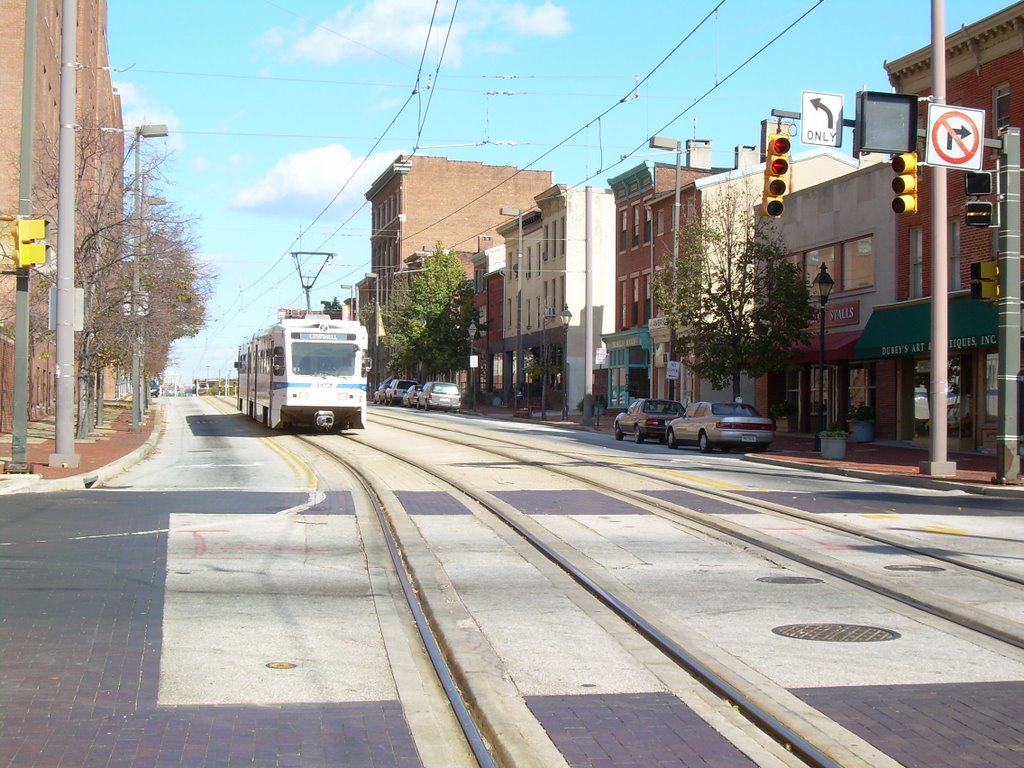
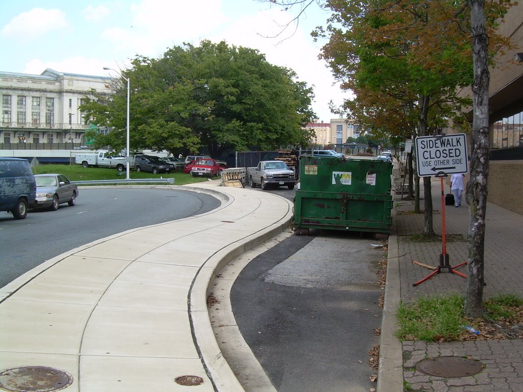
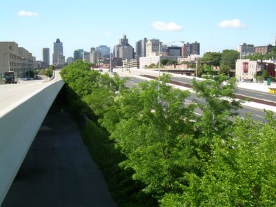
This is Gay Street looking southward from North Avenue. There are three lanes, curb to curb, next to the very narrow sidewalks which are next to mostly blighted housing and vacant lots. Parking is never allowed on the northbound curb, where the bus is in the picture above. Parking is allowed except between 7 to 9 AM and 4 to 6 PM on the southbound curb. The center lane is designated for reversible traffic flow. The southbound sign says, "Curb Lane Only 4 PM to 6 PM", which means that the southbound traffic must use only the curb lane between 4 and 6PM, because the center lane is given over to the northbound traffic (leaving downtown) during the evening peak period.

The most obvious problem created by the parking regulations is having fast-moving through traffic and buses mere feet away from the houses, 24 hours a day. How could a residential community possibly endure under such conditions? The answer is that it cannot and has not.

But there is an even larger traffic problem. Until 4 PM each day, parking is legal along the southbound curb. Then at exactly 4 PM, parking on the southbound curb becomes illegal and at exactly that same moment, the southbound curb lane becomes the only lane available for southbound traffic. At 3:59 and 59 seconds, the center lane is designated for southbound traffic and exactly one second later, that lane becomes designated for northbound traffic.

Furthermore, there are no electronic signals to choreograph this split-second transition from southbound to northbound traffic in the center lane, or from parking to no parking along the southbound curb. There is nothing to synchronize the watches of the motorists making this transition, or to inform the motorists who have no watches or are not looking at their watches.

In other places with reversible lanes (the Bay Bridge for example), there is a time period when the reversible lanes are not used in either direction. The reversible lanes are swept clean of traffic so that a transition can be achieved for use by traffic in the opposite direction. This is not done on Gay Street because at the split second before the transition occurs, it is totally legal for a car to be parked in what becomes the only southbound traffic lane one second later. There is no time to ticket or to tow these cars, which in the Baltimore City government are two separate time-consuming processes.

But what the signs say is not what actually occurs on Gay Street. What actually occurs daily in the center lane of Gay Street is a good analogy for life in general in this forlorn neighborhood.

First of all, the public laws are rendered meaningless. It is a common occurrence to see traffic traveling in both directions in the center lane simultaneously. One driver or the other has the legal right to be there based on who is adhering most accurately to the clock. Of course, what it really amounts to is a case of the drivers staring each other down and one of them baling out. It may be the one who is in the right, or it may be the one who is in the wrong, or it may be the one who is least strong-willed (i.e. has the least balls) or it may be the one who is more able to pull to the right and manage to avoid the traffic or parkers in that lane.

Secondly, the true law that governs local behavior is the law of the street. Sane drivers avoid the center lane. Of course, if the curb lane is blocked, legally or otherwise, one cannot avoid the center lane. So the most sane drivers avoid Gay Street altogether, which is the chief reason why Gay carries less traffic here than north of North Avenue where it is called Belair Road. Slightly less sane people will drive on Gay Street but try to avoid the center lane. Still farther down on the sanity scale will be the drivers who seek out the center lane and "dare" opposing drivers to do likewise. Still further down the sanity scale will be those who dare to park their cars on Gay Street near the 4 PM bewitching hour. Finally, there are the most crazed and desperate - those who live on Gay Street. There are not very many of those people anymore.

It is not difficult to image how the "law of the street" regarding traffic regulations might fit into the local etiquette regarding other endeavors of neighborhood commerce and social life. It takes a lot of nerve to survive on Gay Street.

But what is truly astonishing is that the posted traffic regulations on Gay Street are the exact same as they have been for decades. Once upon a time, Gay Street was a nice neighborhood. It was certainly a much nicer neighborhood when the current traffic and parking regulations were put into effect (the 1960s? the 1970s?) than they are now.

This illustrates the slow quiet cancerous effect of bad traffic and parking regulations and urban problems in general. Not many people are going to just get up and leave town when the City puts some up some traffic sign in front of their house that they don't like. You may not even have a car so you may not even give it much thought. Many City people didn't own cars back then and many still don't. The City's attitude has always been to deal with parking problems where there are a lot of parkers. After all, the squeaky wheel gets the oil.

The biggest event on Gay Street in recent history was the riot of 1968. That was south of this area, and that portion of Gay Street was then closed completely and turned into a pedestrian mall. That has generally been regarded as a failure too, but it is interesting that it was exactly the opposite kind of failure that Gay Street has experienced between North Avenue and Preston Street. It was a failure of no traffic, as opposed to a failure of traffic. At least it was not a failure of neglect.

The larger lesson is this: An urban neighborhood must be nurtured as a neighborhood, not as traffic moving on a street to be manipulated by signs and regulations that are far less powerful than the innate laws of urban survival, growth, life or death.

November 17, 2006

NEW JONESTOWN:
NOT ABOUT A ROUNDABOUT

The City has given us another example of how NOT to design a roundabout, or maybe a non-roundabout. Who knows what they were thinking when they designed the thing at East Lombard and Albemarle Streets in the New Jonestown housing development?

Previously, we discussed the failed roundabout at Wilkens and Mount Street, but at least that was a real roundabout. This one is basically just a traffic obstacle, and not a very good one.


Lombard is a two lane one-way westbound street when it approaches the non-roundabout. One lane is striped to go to the left of the obstacle and one lane to the right. As you can see from the picture above, the orange barrel that denotes the place where traffic is not supposed to go (straight ahead) has been knocked over by someone who indeed drove straight ahead. The barrel replaced a sign that was previously supposed to inform drivers not to drive straight ahead, but which was also knocked over by someone who drove straight ahead.

Things are actually even more confusing beyond the non-roundabout where the street comes back together. The lane to the left of the roundabout re-emerges beyond Albemarle as a lane where parking is allowed at night. There is nothing, not even a barrel, to inform drivers that the one and only lane between the curbs to the left of the non-roundabout becomes a parking lane. Either the driver will crash into the parked car that occupies its lane, or try to swerve to the right into the lane that may be occupied by a driver swerving from the right and who legally has the right-of-way.

In sum, the one left lane often becomes zero, while the one right lane becomes two. This is really stupid.

So what was the reasoning behind this non-roundabout? It looks like an extremely lame attempt to create a Savannah-style neighborhood park to add interest to the setting of the new houses. EXTREEEEEMELY LAME, I'd say. You'll notice from the photograph above that there are no benches or street furniture in the space. There are no trees. There is no art or sculpture. There is nothing except an orange barrel, that replaced a sign, both of which have been knocked over.

But it's even worse than that. You'll notice from the photograph that there is absolutely no parking allowed in the block that contains the non-roundabout, even though the total width in this block is about twice what it is in the blocks before and after, both of which allow parking at least during off-peak hours.

This is a major deficiency throughout the New Jonestown neighborhood. There are many block faces where parking is not allowed. On-street parking is a very important element of urban neighborhoods in places like Baltimore. No matter how good a house's rear access might be, there are times when you might want to park in the front to bring something in the front door.

Moreover, streets without on-street parking have a desolate quality which allows the through traffic to dominate. A comparison to adjacent Little Italy is revealing. Much more on-street parking could have been provided in New Jonestown with just a bit more attention to traffic patterns and curb locations. Without parking, nothing stands between moving traffic and pedestrians. Except maybe an orange barrel.


Then again, sometimes the City actually does things right. Above is the new median strip that was recently completed in South Broadway between Baltimore and Fleet Streets in Fells Point. It replaces a meager four foot wide concrete strip. Broadway still has four lanes - two in each direction - and approximately the same number of parking spaces. But previously, the parking spaces were head-in at an angle, so the entire street looked like a big parking lot. Now it looks like a street in the best sense - not just a place for cars, but also for people. The amount of pavement has been reduced, while the functionality has increased as four rows of parallel parking has replaced two rows of angle parking.

Some might argue that there is too much loitering on Broadway. But even loiterers try to find the best place to do their thing, so what are you going to do? Make a place unattractive just so loiterers will stay away? That defeatist attitude is just what is often used to design places, to strive for mediocrity.

Instead, we should strive for high-quality loitering. Loitering should be very public. It should not be allowed to slip into semi-private recesses where it appears mysterious and potentially threatening. In the public realm, activity should be public, while private places should be clearly private.

There should be no room for ambiguity. Questionable police actions and arrests are the result of such ambiguity. A public space that is obviously public helps make human actions explicit, especially among loiterers. Ambiguity is thereby eliminated, and both the police and the citizens will know where we stand.

The most public urban places are in the middle of median strips, clearly separate from anyone's private property or space. The City needs to have median strips that are hospitable, attractive and well-designed. Benches, trees, landscaping, and on-street parking can all be used to contribute to this.

These lessons can be applied all over Baltimore, most notably to Pratt Street in the Inner Harbor, where loitering is now allowed to hide and fester behind large earth berms. This portion of Pratt Street would be an ideal place for a highly visible median strip that separates through traffic from the service drive for Harborplace, the World Trade Center and the Aquarium. This median could efficiently and unambiguously serve a bikeway, a transitway, and yes, loiterers. It could be done even better on Pratt than many other streets because this section of Pratt has no cross traffic.

South Broadway is an outstanding example of how this can be done right. West Lombard at Albemarle is an outstanding example of how this can be done wrong.

October 29, 2006


THE RED LINE SHOULD TURN GREEN


Running Red Line rail transit through the streets of Fells Point would repeat the same mistakes that were made when the Central Light Rail line was rammed down Howard Street, only worse. Light rail has done little to help Howard Street. It has overwhelmed the small-scaled streetscape to accommodate the block-long 300 foot trains and has eradicated vital on-street parking in the process.

Regional rail transit is effective only when it is fast and fits in. On Howard Street, light rail is painfully slow and could be even slower on the narrower Fells Point streets, where unlike on Howard, it would have to share its lanes with traffic.

Instead of running the Red Line on the streets of Fells Point, regional rail in East Baltimore should be built as an extension of the existing Metro Green Line, east of the current Hopkins Hospital Station. This can be built in a corridor in which rail transit can be established properly from the "ground up" rather than as a weak retrofit, where it can truly serve regional travel needs, and where a brand new culture of transit oriented development can be created.

As illustrated on the diagram above, six potential station locations along a three mile East Green Line Extension have been identified where regional rail transit can become a true foundation for the future.


The above photo shows light rail on Howard Street looking north from Madison in the Antique Row district. This illustrates how NOT to provide regional rail transit. From the neighborhood perspective, the biggest and most obvious problem is that parking has been totally banned from the west side of the street (to the left). Merchants in areas like Antique Row and Fells Point rely heavily on street parking for their customers.

Another problem here is that the closest light rail station is two blocks away. Regional rail can only perform properly if stations stops are spaced at least a few blocks apart, and activity will not be attracted to transit if it is not oriented to these stations. Moreover, on Howard Street, much of the parking has been wiped out on all blocks, but in Fells Point, the blocks with stations would be the ones that have their parking eliminated.

On Howard Street, the light rail runs painfully slow. But in Fells Point, it would be even slower, because the streets are narrower and there would be no way to keep the very heavy traffic off of the tracks, and since three car trains would take up an entire block, there would be no place else for the traffic to go.

Light rail is supposed to evoke fond memories of streetcars, but that is where the similarity ends. It is streetcars rather than light rail that would be at home on the streets of Fells Point. Unlike light rail, streetcars require stations that are only slightly longer than bus stops, so the lost parking would be negligible, even if stops were more frequent. Light rail is also intended to serve longer trips, such as Hunt Valley to the airport or Social Security to Canton, so travel speed is of the utmost importance. That is why light rail is out of place on slow downtown streets, whether in Antique Row or Fells Point.

Light Rail transit is supposed to transform the places it goes through, but on Howard Street or Fells Point, the transformation can only be for the worse.


The photo above shows the corridor where regional transit should be located in East Baltimore: As an extension of the existing Green Line Metro along existing rail rights-of-way for Amtrak just north of Eager Street and an unused Conrail branch just east of Haven Street.

Unlike the Red Line culture clash in Fells Point, fresh opportunities would be created at station areas along an east Green Line. They include the following:


BIOTECH PARK - This photo, looking east along Eager Street from Washington Street to Broadway, shows what a radical change is now taking place just north and east of Hopkins Hospital, where many blocks of new houses and employment centers are about to be built. The Metro subway currently ends right under the portion of Broadway shown in the background here. Now is the time to plan for a Metro extension that would proceed under this section of Eager Street and rise to the surface in the Amtrak corridor just a block to the east. A station could be incorporated into the portal where the Green Line would emerge from underground, thus making it much easier to build, secure, and assimilate into the community.


BEREA/MADISON PARK - Further east along Eager Street, the Amtrak corridor is lined with marginal and abandoned buildings and vacant lots that are ripe for redevelopment as central elements in the effort to expand the redevelopment momentum created by the Biotech Park. The City has already begun efforts to acquire property for redevelopment, both here and to the north near the American Brewery.


This view provides an overview looking west from Edison Highway toward the Hopkins Hospital skyline. The Amtrak tracks are under the power poles on the right. The Metro extension would be just left of the Amtrak tracks under the large trees.


EDISON/MONUMENT - This huge tract adjacent to the Amtrak tracks would be a perfect location for a comprehensive transportation hub, serving both a Metro Station and a MARC Commuter Rail Station, as well as bus transfers and parking. This will facilitate easy connections between thousands of daily bus and rail trips between Cecil, Harford and Baltimore Counties, Downtown Baltimore, and all the way to Washington D.C. It would thus be a vital link to the State's strategy for accommodating the thousands of new federal and spin-off jobs for the expansion at Aberdeen, Fort Meade and in the DC metropolitan area. This is crucial to creating a true REGIONAL transit system and diverting traffic overload from I-95 as well as the surface streets of East Baltimore.

Additional development to support the transit line and/or maintenance facilities may also be provided, including a replacement facility to allow redevelopment of the MTA bus yard on Oldham Street, which is the critical link between Greektown and Bayview for the continued expansion of housing and health-related jobs.


The Southeast Metro Extension would diverge from the Amtrak right of way at Haven and Monument Streets, and then proceed southward along an unused rail spur owned by Norfolk Southern which begins at the two bridges shown here over Haven (to the left) and over Monument Street (to the right.) Amtrak is on separate tracks just behind these two bridges. A spur eastward to Bayview and beyond could be easily built from this point.


HIGHLANDTOWN/GREEKTOWN - The Green Line extension would swing southward from the Amtrak corridor on an unused rail branch just east of Haven Street. The station location shown here is at Eastern Avenue in Downtown Highlandtown, which is the past and future central hub of southeast Baltimore (NOT along the waterfront where development is virtually all done). The huge vacant Crown Building is shown in the background, and represents the vast redevelopment potential of this area, extending into Greektown and Bayview to the east.


BREWERS HILL - Streuver Brothers is already doing much to redevelop this area, including the Natty Boh Building and vicinity, but that is just the tip of the iceberg. The transit line would occupy the green swath to the right of the photo above taken just south of O'Donnell Street, surrounded on both sides by new development opportunities.


CANTON CROSSING - The transit line would terminate at the Ed Hale waterfront complex, near the intersection of Boston and Conkling Streets. The high rise First Mariner Bank Building shown is just the first phase in creating a new urban center to extend development beyond the waterfront toward the east.

September 29, 2006

CANTON:
EXTRAORDINARY BECAUSE IT'S ORDINARY

You hardly ever hear the term "Gold Coast" applied to Canton anymore. Canton isn't really all that golden. It's more a nice shade of bronze. Compared to the glitzy buildings that are going up at a frenetic pace in Harbor East, Harbor South and Harbor West, Canton is just a comfortable classic timeless kind of place.

Canton isn't really all that much about the coast anyway. The story of Canton in the 2000s is much more about how it is spreading inland. The coast provided an anchor and an impetus for renewal but little else. Middle class folks have chosen Canton to settle down after looking around Baltimore for a nice safe secure piece of real estate. Canton was not given a whole lot of high profile encouragement from the City government. It was more like folks asking themselves, "Where can I find a place that isn't likely to get screwed up by the violent forces of urban change over which I have no control?" Canton was the place.

Canton isn't about major big dollar cataclysmic urban renewal or transportation projects. It isn't about fabulous irreplaceable old architecture. It isn't even about major gut-job housing renovations.

The housing in Canton is rather ordinary. It isn't even standard ordinary. It's hodge-podge ordinary. It may have started out as the kind of crisp, uniform, standard issue "American Dream" sort of housing that later made Levittown famous, but like Levittown, the housing and the dreams they represented eventually became much more individualistic. In Canton, it happened first by covering the brick with formstone and adding various other adornments and additions, and is now most often expressed by that postmodern urban accessory - the roof deck.

Roof decks reflect the prevalent attitude that Baltimore looks its best when seen from above, where the fine grained problems of urban living blur out of focus. Cantonites don't sit on the front stoops a whole lot anymore, but they don't want to mow the lawn either. They don't even sit up on their roof decks all that much. They mostly just come and go with a private personal purposefulness of people whose neighborhood is a useful backdrop for their lives. In Canton, unlike most of Baltimore, the livin' is easy.

The public improvements that Cantonites have demanded are also modest. This has not always sunk in among the city planning types who were raised on Daniel Burnham's big plans. Canton didn't want anything more lavish than a Dog Park, to take care of their best friends, their dogs.

Another major landmark of Canton's social scene is the big Safeway supermarket, which looks like it was plopped down from the most banal of suburbs. But Cantonites go to be seen in their Safeway, whether they will admit it or not. The O'Donnell Square commercial area is much more tasteful, but the taste is definitely imported and eclectic - it is not the authentic preservation of some "genuine" Canton tradition from years gone by.

The Canton street system is a basic grid that works well as long as the traffic volumes are kept reasonable, which they are. Cantonites don't ride transit all that much and they wouldn't use a bigtime regional transit system enough to justify it.

The traffic improvements demanded by Cantonites are small. They are: (1) Angle parking, and (2) Four-way Stop Signs. It took a long time for the City to catch on, but grudgingly it appears that they now are beginning to. For Canton, these modest measures are more effective than the monster parking garages and overchannelized oversignalized intersections the City promotes elsewhere. They're just about all Canton really needs.

The great thing about Canton is that there are numerous potential Cantons all over the city. Canton's success could be replicated almost everywhere if people had any confidence that urban living could really work for them there.

The problem is that Canton-style urban living currently doesn't work anywhere else. Of course, unlike Canton, cataclysmic help is indeed needed in many areas of Baltimore. Many areas do indeed desperately need superior mass transit, which they are not getting. Not to mention good schools, safety from crime, drugs, etc. , etc., etc.

But Canton is a wonderful reminder that most folks don't ask for a lot, and can be very happy with what they have. Baltimore needs lots of Cantons to fill in the urban spaces between the gold coasts, the high density mixed use urban centers, the world class institutions and the unique extraordinary architecture. Hopefully some day we will.

As a result of low supply and high demand, housing prices are too high in Canton for the housing you get. This is not a consequence of some conspiracy by yuppies or developers or defective zoning laws. Since there is only one Canton, you simply have to pay the going rate to live there. People looking for a lower cost alternative are settling in other places such as Highlandtown. Hopefully, they're learning to like Highlandtown, which has its own unique charms, because they're not getting a Canton. It is really a shame that Baltimore has only one of those.

September 27, 2006

Penn Station: What's wrong with this area?

Don't worry about the 50 foot Man/Woman sculpture or the dearly departed Odorite Building. Urban landmarks come and go, and fretting about them is mostly just a source of bemusement for the powers that be.

What we should not forgive is the way the streets and transportation infrastructure around Penn Station have been abused and neglected for no good reason, resulting in a dangerous, ugly, hostile, inconvenient and desolate human environment. So without further ado...

Here are the Top Ten Transportation Abuses in the Penn Station area.


#10 - POLICE CARS UP THE CURBS AND ORANGE BARRELS ON THE DRIVEWAYS - Whatever alleged majestic grandeur the Man/Woman sculpture is supposed to evoke is pretty much nullified by the semi-permanent presence of police cars at the feet of their plaza. This seems to be standard police procedure everywhere in Baltimore. The Police apparently assume that the City revolves around their duties. It probably does, but do the rest of us have to have that fact continually ground into our senses? No pedestrian plaza or promenade seems to escape becoming the appropriated parking spaces for our city's finest.

There are almost always easy alternatives to such police parking. At Penn Station, there are parking spaces along the curbed driveways that are constantly blocked off with big orange construction barrels. Why can't the police park there? Probably because they want to be "in yo face", as if that wasn't already painfully obvious.


#9 - THE WORLD'S SHORTEST LIGHT RAIL ROUTE - After all the double tracking construction dust has settled, the MTA has decided that the Penn Station light rail route should only run a grand total of 1000 feet as the crow flies. The photo above is from the far end of the line, only two blocks from the station. Its amazing that this decision has not led to major derision for the MTA, but it is even more embarrassing that this was actually probably the best decision for them to make, which is why it is only ranked #9 here. It allows the MTA to time the trains to try to serve transfers to both the north Timonium/Hunt Valley and south BWI-M Airport/Cromwell Station routes. It also mainly points out how useless it was to build this spur in the first place, instead of focusing on creating a decent environment around Penn Station for pedestrians to walk modest distances to and from the station. Which leads us to...


#8 - THE CHARLES/OLIVER STREET PEDESTRIAN DEATHTRAP - The most popular place for Penn Station patrons to cross Charles Street is in the vicinity of Oliver Street, shown above. The City does absolutely nothing to encourage people to cross there, making it as dangerous as possible, which will probably be a successful strategy until someone is killed. And some lawyer would probably tell them until then that this is an acceptable strategy. If you provide signals and crosswalks where some people don't want to cross Charles, such as just north of the JFX ramp (but not for the ramp itself, see #1 below) and at Mount Royal, then you don't have to provide them where they do want to cross. The City also tries to discourage pedestrians on Oliver Street by allowing...


#7 - THE PERMANENT OLIVER STREET JUNKPILE - Oliver Street is the only pedestrian link from Penn Station to the west, including the very significant Bolton Hill neighborhood and the Maryland Institute College of Art. But the City has conspired with the Univeristy of Baltimore to turn the block of Oliver Street leading to Penn Station into a junkpile. There is a permanent fenced enclosure for a dumpster just north of the street (background in the photo above), and as we all know, junk begets junk, so a second dumpster has been placed in the street bed (foreground above). The entire surrounding area is now constantly filled with various stuff and parking of various shades of legality. The "S" shaped curb shown above along the Maryland Avenue JFX ramp, right in the middle of Oliver Street, defies any known street design criteria, and just shouts out the feeling that any sort of crap in the middle of Oliver Street will be an acceptable accoutrement. Oliver Street should be a prime inspiration for transit-oriented development linking Penn Station with Bolton Hill, MICA, and some very key development parcels including the critical former Bolton railroad yard which is now a huge U of B parking lot and light rail station at the corner of Oliver and Mount Royal (see light rail photo above). But the state of Oliver Street makes it unlikely that potential developers, clients and users will ever be able to envision this area's potential. In such cases, transit-oriented development becomes only hype rather than substance.

#6 - THE MARYLAND AVENUE JFX OFF-RAMP - The ramp from the JFX to Maryland Avenue already violated expressway design standards, but it was recently rebuilt with even tighter curves to accommodate the widening of the expressway. The way that this ramp dumps traffic into the Maryland Avenue/Oliver Street intersection also goes a long way to prevent Maryland Avenue from being the civilized urban connection necessary between Penn Station and Bolton Hill and squanders a prime parcel of land near the station. The Maryland Avenue ramp should be relocated away from Oliver, north of the Post Office fleet maintenance shop (another inappropriate land use) where it will cause no significant human harm and serve traffic much better.

#5 - NO PARKING ON CHARLES STREET - The City used the recent occasion of the painfully laborious Charles Street bridge reconstruction adjacent to Penn Station to wipe out most of the heretofore legal on-street parking that used to take place there. Why they did that is difficult to fathom. Certainly the short-term parking was important to the station, was well-used and added life to the street. It also slowed down the traffic racing to get on the JFX and somewhat dissuaded drivers from pretending that they were already on the JFX when they were still on Charles. But now the blocks of Charles between Mount Royal and Lanvale stand apart from the rest of the city's venerable main street like the mini-freeway that it has become. South of Mount Royal and north of Lanvale, parking is allowed at the left curb 24 hours a day, but it's "No Stopping Any Time" in the three blocks in between. On the right curb, parking is allowed all the time north of Lanvale and 22 hours a day south of Oliver, but never in the blocks in between. JFX traffic is not a factor in the right lanes, and there is little change in traffic passing Lanvale, so what gives?


#4 - NO PARKING ON ST. PAUL STREET - Things are even stranger on St. Paul Street. Just south of the Penn Station driveway, there are permanent pylons in the right lane of St. Paul Street which guide the traffic exiting from the driveway to make a tapered merge into St. Paul Street, as if they were merging onto an Interstate Highway. The pylons also prevent an entire block of valuable on-street parking from taking place and thus deadens street activity. For a local city street, this is truly bizarre, and is done nowhere else in Baltimore (as far as I know). What is it about this area that it gets such a strange traffic treatment to accommodate a routine signalized right-turn? Again, parking is allowed along this right curb north of the Penn Station driveway, so there is no apparent reason from a traffic standpoint for preventing it to the south. It is also curious that parking is prohibited in this lane in the morning peak period to the north all the way from Charles Village to north of North Avenue, then is allowed from North Avenue to Penn Station, then is prohibited again south of Penn Station. There is no significant change in traffic volumes or patterns along this entire segment, only a change in the way the City looks at it. This forces a lot of sleepy Charles Villagers to wake up extra early just to move their cars out of the street.


#3 - JFX OFF-RAMP TO ST. PAUL STREET - The design of this ramp is truly pathetic. It dumps exiting Jones Falls Expressway traffic directly into the St. Paul/Mount Royal intersection, but the sorriest looking pylons are used to try to force the expressway traffic to stay in the right lane of St. Paul, so that the St. Paul flow is not interrupted. This creates a mess. Traffic from both St. Paul and the ramp routinely violate this separation and also block pedestrians at the same time. This ramp was built as part of the temporary terminus of the JFX north of downtown back in the 1960s, but as we all should know by now, many temporary things become permanent, no matter how half-assed their original designs may be.

#2 - ST. PAUL EXPRESSWAY TRAFFIC DUMPING GROUNDS - What's even worse is that four decades ago, this JFX ramp created a dumping ground for traffic from the expressway that should have stayed on the expressway all the way downtown. St. Paul Street in Mount Vernon has never recovered from this. The segment of the expressway between the St. Paul exit and downtown was never designed to handle all the downtown bound traffic generated by the expressway, mostly due to the delusion that the expressway would eventually be extended though Fells Point and would thus carry through traffic instead. The result is that St. Paul Street in Mount Vernon is one of the most oppressed trafficways in the entire city. The ramp connection to St. Paul should be closed, with only its Mount Royal connection maintained, and traffic should be rerouted to other expressway exits that can better handle the load. St. Paul could then be transformed into a civilized street befitting its distinctive residential character.


#1 - CHARLES STREET JFX RAMP PEDESTRIAN DEATHTRAP - This ramp carries over a thousand cars in the evening peak hour alone, peeling off of Charles Street as fast as automotively possible, directly across the sidewalk contiguous with the west side of Charles Street. And yet, believe it or not, there is not even one, single, measly, solitary trace of any sort of sign, crosswalk, signal or any other traffic control device to warn or regulate either motorists or pedestrians of the impending conflict, assault or disaster that awaits them at this point. This is unconscionable.

August 7, 2006

FARRING BAYBROOK


No issues. I just wanted to blog some photos where Brooklyn, Downtown, Fort McHenry, Canton, Curtis Bay and Dundalk can all be seen from the same wondrous place.

July 14, 2006

Seton Hill

SETON HILL: CENTRAL CITY'S GREENEST NEIGHBORHOOD
(BUT MOST PEOPLE DON'T KNOW IT.)


Aren't you getting tired of various things being declared "Baltimore's best kept secret"? They're not secrets, they're ignorance. It's an act of pathetic desperation when ignorance is declared a virtue in the name of reverse psychology, or some kind of fake snob appeal exclusivity, or out of some strange fear that publicizing goodness will ruin it.

Take Seton Hill. It is a fantastic neighborhood, built around a huge park that most people would (figuratively) die for. It's closer to downtown than most of Fells Point and Federal Hill, and there's no physical reason why it should be perceived separately from Mount Vernon.

July 7, 2006

Roundabouts

WE INTERRUPT THIS STREET TO BRING YOU A ...ROUNDABOUT

#1
North Avenue is not just a street. It's a state of mind. When you're on North Avenue, it's likely you won't forget where you're going. It's straight as an arrow across the entire urbanized city from Hilton to Milton, and it's 60 to 100 feet of pavement all the way.

Crossing North Avenue is also a memorable experience, especially at Eutaw Place between Bolton Hill and Reservoir Hill. If North Avenue was not considered so significant, people wouldn't be willing to spend twice as much for the same house in Bolton Hill to the south as they do in Reservoir Hill to the north. If anything, the Victorian architecture in Reservoir Hill is even more extraordinary, yet many of its houses have been allowed to crumble to the ground. So it's the domination of a major east-west street, North Avenue, that makes its interruption of a north-south street, Eutaw Place, so significant.

#2
But there's much more to it than that. South of North Avenue, Eutaw Place has an elegant lush green median (see above and below). North of North Avenue, it does not. Back in the 1960s and 1970s, the City made a moat of demolition around Bolton Hill to seal it off from its surroundings. To the east, the east side of Mount Royal Avenue was torn up for the Jones Falls Expressway. To the south, most of Dolphin and Preston Streets were demolished to build the sterile State Office Complex. To the west, most of Linden Avenue was demolished.

#3
Since Linden is east of Eutaw Place, this actually placed Eutaw with its classic green median outside of the protected area of Bolton Hill, but despite some terrible demolition decisions, Eutaw was too beautiful to go down. The nine block segment of Eutaw Place adjacent to Bolton Hill between Dolphin Street and North Avenue remains among America's most beautiful streets, comparable to Richmond's Monument Avenue or Boston's Commonwealth Avenue. The irreplaceable Francis Scott Key monument shown above is a highlight.

But Eutaw Place was not enough to keep the Upton neighborhood west of Bolton Hill from going down, helped along by race riots and other factors such as a decision to inundate narrow McCulloh Street and Druid Hill Avenue with heavy traffic.

#4
The nine block stretch of Eutaw Place with its classic green median remains an urban anomaly. South of Dolphin (see above), a four foot concrete median picks up where the monument studded urban masterpiece leaves off.

#5
But North Avenue has fared even worse. On the segment east of Eutaw Place (see above), the street was widened from 60 to nearly 100 feet, to create room for left turn lanes and full-time parking lanes. Unfortunately, the village was destroyed in order to save it. In the widening effort, the buildings that could have taken advantage of the new parking and left turn access were demolished. The result is wide parking lanes with no one parking in them, a wide median with left turn lanes carved out of it, and traffic whizzing by on either side.

Urban designers know how to solve the void on North Avenue. The void is the lack of a "place". But who wants a place on North Avenue? When a new housing development was built in the southeast quadrant of North and Eutaw a few years ago, the site plan scrupulously avoided orienting anything to North Avenue - providing just a fence to keep North Avenue out. The new housing has been highly successful but North Avenue still is not.

An urban design gesture in the right direction is illustrated at the top of this article (picture #1). Its a little landscaped circle with a diameter of about ten feet and a flower pot in the middle, located at the north end of the Eutaw Place median. It probably looked appropriate on the construction drawings but it is very easy to ignore. North Avenue is a powerful state of mind so it will take a powerful sense of place to confront it.

The real answer for North Avenue at Eutaw Place is just about the same thing, only much bigger - too big for anyone to ignore: The real answer is a roundabout - sometimes called a traffic circle.

Drivers tend to drive in a straight line unless provoked otherwise. Drivers travelling along North Avenue need to be forced to turn. A roundabout forces drivers to turn. A roundabout tells drivers: You are no longer on North Avenue. North Avenue temporarily does not exist. Your state of mind has been interrupted. You must react.

Once a driver turns into a roundabout, he or she enters a totally new frame of reference. The old reference of travelling east or west toward the rest of the city has been replaced by a reference only to the roundabout itself. There is only one direction to go - counterclockwise. The roundabout is utterly an abstraction because it will get you nowhere, except around in circles, and eventually back where you came from to be repeated again and again.

There is only one way out, and that is to let go of your preconceived frame of reference and heed the rules of the roundabout instead. You must pay attention to where you are. You must read the signs and the environmental cues do what they tell you. There is no straight. There is no left. There is only a succession of right turns and you'd better figure out which is the correct one for you or you will travel in circles forever.

The roundabout rule is that drivers travelling around the circle always have the right of way, even though they don't want to go around it indefinitely. In a true roundabout, pedestrians are not allowed into the center circle, so they are not a factor in this.

Other than that, the rules for pedestrians are the same as for signalized intersections. Pedestrians always have the right of way over all turning traffic entering or exiting the roundabout, so it is critical that the roundabout be designed well so that pedestrians are able to invoke their power over turning traffic. This is the source of the roundabout's "traffic calming" effect.

Many drivers hate roundabouts. There is a disturbing lack of progress, a disturbing sense of infinity about them. Roundabouts require drivers to take responsibility for their own actions, to make eye contact with their fellow drivers and pedestrians, and yet one must proceed in a direction that is not of one's own choosing. Of course, "hate" is a relative term. Many drivers hate North Avenue anyway. And when voting with their feet, most real estate buyers have had a lowly opinion of North Avenue for many years.

In a well designed roundabout, drivers are subservient to pedestrians, and all are subservient to the place itself. This is key. Drivers only have to go through the roundabout momentarily and then they are on their way. But the place itself is there 24/7/365. North Avenue is always where it has always been, even if only a shadow of its former self. People escape North Avenue but North Avenue cannot escape itself.

A roundabout is a place that must be recognized, confronted and reacted to. It is a place to put a statue or monument. It is a place to bridge the gaping gulf between Bolton Hill and Reservoir Hill.

#6
The Maryland State Highway Administration has become quite adept at building roundabouts, such as the one shown here at Wilkens Avenue and Hilltop Road adjacent to UMBC. The formulas for determining the proper geometry of roundabouts and their approaches is quite exacting. This can tend to give a somewhat bland generic quality to roundabouts, but it doesn't have to.

The Baltimore region's roundabout in extremis is located in downtown Towson at the intersection of York, Dulaney Valley, Allegheny and Joppa Road. There have been many complaints about the Towson roundabout, but anyone who remembers what this intersection was like before must admit that it is quite an improvement.

The Towson roundabout is actually a victim of its own success. The huge amount of traffic it handles is a major testament to its effectiveness, and yet it would work even better if it carried somewhat less traffic. Roundabouts can carry huge traffic volumes, but there are limits, and they are no substitute for good traffic management on the approach and bypass streets which Towson sorely needs. But if a roundabout will work there, it will work on almost any urban intersection where space permits.

#7
Baltimore City has much less experience with roundabouts, and it shows. The one shown above is at Wilkens Avenue at Mount Street. Trucks and even large cars routinely violate the striping and jump the curb into the circle, leaving tire tracks in the bare dirt. (And why do city street trees all seem to die so quickly?) Of course, space is usually at a premium in the City, but if there is not sufficient room for a well designed roundabout, then it shouldn't be built.

There are many good locations for roundabouts in Baltimore, and the intersection of North Avenue and Eutaw Place is among the best. Imagine the intersection not as simply a place to be gotten though. Imagine the landscaped circle shown at the top of this article (picture #1) as something that is too big to ignore, right in the middle of the intersection where it must be recognized and confronted.

The intersection of Eutaw Place and Dolphin Street, nine blocks south at the other end of the grand Eutaw median (picture #4), would also be a great roundabout candidate.

Roundabouts are unique among traffic treatments in that they can handle very high traffic volumes, but can still calm the traffic in a way that makes it palatable to the adjacent communities. In this way, heavy traffic can be attracted to the streets which can best handle it rather than the streets with the least political clout.

In the vicinity of Eutaw Place, it is McCulloh Street and Druid Hill Avenue which have suffered from this fate of being the traffic dumping ground. While they are far narrower than Eutaw Place, they carry more of the traffic burden, which tends to reverberate in the tight canyon between the closely spaced rowhouses. McCulloh and Druid Hill were originally designed as small local streets, and were never intended to carry the traffic burden they have been forced to take on. Roundabouts on Eutaw Place could be implemented in conjunction with changes to traffic patterns in Upton, Seton Hill and Druid Heights to encourage traffic to use Eutaw Place instead of McCulloh and Druid Hill, thus providing traffic relief to the entire area.

Of course, it's obvious that North Avenue has long been a dumping ground for heavy auto and truck traffic, and roundabouts would provide relief without reducing its ability to accommodate traffic instead of dumping it onto other nearby streets. As a tool for regulating traffic patterns, roundabouts can be used as both carrots and sticks.

In conjunction with the roundabout, West North Avenue should be narrowed back to approximately its original width or less. It should be no wider than necessary to serve any adjacent land uses and prevent bottlenecks from forming. The roundabout could then serve as a vital catalyst for reweaving the urban fabric that has long created scars between Bolton Hill and Reservoir Hill.

June 15, 2006

Mt Vernon-Belvidere

MOUNT VERNON-BELVIDERE:
LEAPS AND BOUNDARIES

Boundaries can have a huge effect on a neighborhood, and a perfect example of this is the effect of the Jones Falls Expressway corridor (JFX) on the Mount Vernon/Midtown neighborhood. Even before the expressway was built in the 1960s, the neighborhood was cut off from east of Guilford Avenue by various railroad tracks, an imposing elevated transit line and by The Fallsway, a highway so-named because it was built on top of the buried Jones Falls river. These interrupted the urban fabric without attracting enough people or cars to be very useful. While Charles Street three blocks to the west was considered Baltimore's main street, Mount Vernon turned its back on the Jones Falls corridor. The elevated transit line was torn down in 1950, the various railroad tracks were abandoned at various times, and when the JFX was built in the 1960s, the Fallsway was largely moved out of the way and converted to a northbound service drive.

June 9, 2006

SOUTHWEST PARK: THE LOST CONTINENT


Baltimore has an outback that is so vast as to achieve mythical proportions. Most of it looks like it is in pristine natural condition, while another huge part has been taken over by uses that are so ugly, marginal and inconsequential as to be rendered almost as invisible as the natural magnificence that it hides.

And all of the above is conveniently located near major highways and the light rail line.

This is the "Lost Continent" of Southwest Park, located just south of Patapsco Avenue along the Baltimore City/County line. With a name like Southwest Park, the place must be so obscure as to have been off the radar screen of the name-makers who have stuck names of note to almost anything. Southwest Park sounds like a name that planners would stick on a land parcel in some obscure technical report that was long ago banished to a dusty shelf. Southwest Park also hearkens back to the early days of suburbia when places off the previously beaten track were mostly named after their location relative to downtown, as if that was their only source of identity - e.g. Northwood, Westview, Eastpoint, Southdale.

The park is also sometimes referred to as Southwest "Area" Park, which reeks even more strongly of planner-ese. Can you imagine anyone referring to Yellowstone Area Park or Yosemite Area Park?

The photograph above only hints at the magnificence of Southwest Park. A small branch of the Patapsco River is shown toward the right, but the main river itself is hidden behind the trees to the left, and can only be seen up close. The photo below looks northward toward a huge parcel relegated to truck trailer storage, located on top of a huge land mass that is probably a former landfill.


Seen from the park valley floor, the vast metallic expanse of sun-glistened truck trailers in the distance looks like a mythical "shining city on the hill". Yes, indeed, this "trailer trash" is a placeholder land use for something in the future that could allow humans to take full advantage of this magnificent view and natural resource.

Here is the same mountain of trailers as seen from the north on Patapsco Avenue. An even more varied assortment of industrial debris occupies this part of the site.

Below is another view of the trailer trash looking westward on Patapsco Avenue. The light rail line is shown by the overpass on the upper right. The Patapsco Avenue light rail station is just to the left of the overpass, behind the trees.

All of this would make a fantastic new transit-oriented community, with intimate access to the light rail system for easy access to downtown and the airport and close-by access to I-95 and I-895, including the "Lost Highway" to I-97 (see previous article). The trailer trash could be replaced by the highest and most humanly intense uses that could be supported by the whatever geological constraints the trash mountain may impose.

Southwest Park is one of those places that a previous generation used for its own purposes, but left open for better use in the future. Off to the east is Brooklyn Park, an attractive community built before the sprawl era, but one which is not fully appreciated now. Brooklyn Park is cut off from Southwest Park by I-895 and by a huge sound wall, that prevents some wonderful views.

The Patapsco River is also in front of the wall and the highway, and is even more hidden from the community - almost totally in fact. In the photo below, the only sign of I-895 is a sign, across the wide river from the park. The Patapsco Avenue bridge is barely visible in the distance.


This is the broad Patapsco River as it was known to Baltimore's original explorers, who could navigate as far upstream as Ellicott City. Now almost all of the visible Patapsco River can be seen only as a small stream. Southwest Park is one of the few places where the Patapsco River can be seen as a real full-fledged river.

Southwest Park is like the lost continent of Atlantis, ready to be found and ready to be given a second chance. So now, the Baltimore Region should recognize Southwest Park for its opportunities to create the types of ideal relationships between nature and urban development that were squandered during the sprawl era of the last half of the 20th century - with human and transit-oriented development overlooking a beautiful natural expanse. Who knows? Politicians may even want to rename Southwest Park after a real person.