Outgoing Mayor Stephanie Rawlings-Blake said she would offer the governor an alternative plan for the Red Line light rail project. Then she changed her mind and said that was the governor's job.
Wrong! The purported purpose of the defunct Red Line was to transform the city. It's up to the city to determine how to transform the city.
Until now, rail transit has done a very bad job of transforming the city. The central light rail line is flanked by boarded up buildings on Howard Street, even decades after completion. When riots broke out last year, one of the first things officials did was close the Metro, as if they didn't know its role. Both the city and transit administration (run by the state) were complicit in this. Meanwhile, portions of the city that are actually growing have not waited for rail transit.
It should be clear: Area plans must come first. That's the city's job, not the state's. This is especially important because the timing of everything is so uncertain. Not all plans are equally alive or dead. The Red Line's fatally flawed downtown tunnel is so dead that rigor-mortis is setting in, while the "Highway to Nowhere" segment is merely in a coma.
Red Line planning can be divided into seven city areas, each with a different status and context for how change can take place. A primary reason the Red Line died was because it was an all-at-once project. Area plans were expected to serve the Red Line project, when it should be vice-versa.
To proceed forward, here's a review of where the seven planning areas stand, west to east. (Anyone looking for my proposals can find them everywhere else in this blog.)
In this area, the Maryland Transit Administration and the city recognized during the Red Line process that a surface rail line built to full light rail standards would have been an unacceptable intrusion on the communities. That led to the dead tunnel plan. But an actual resolution is far simpler: Design the line to streetcar standards (single vehicles in mixed traffic) instead of light rail standards.
Streetcar lines such as this, as well as in other areas such as Charles Street and the Mount Clare Corridor, would use the light rail Red Line as a central trunk, and proceed from there.
The transportation role of streetcars is very similar to that of circulator buses, which can be easier to implement for the shorter term.
Wrong! The purported purpose of the defunct Red Line was to transform the city. It's up to the city to determine how to transform the city.
Until now, rail transit has done a very bad job of transforming the city. The central light rail line is flanked by boarded up buildings on Howard Street, even decades after completion. When riots broke out last year, one of the first things officials did was close the Metro, as if they didn't know its role. Both the city and transit administration (run by the state) were complicit in this. Meanwhile, portions of the city that are actually growing have not waited for rail transit.
It should be clear: Area plans must come first. That's the city's job, not the state's. This is especially important because the timing of everything is so uncertain. Not all plans are equally alive or dead. The Red Line's fatally flawed downtown tunnel is so dead that rigor-mortis is setting in, while the "Highway to Nowhere" segment is merely in a coma.
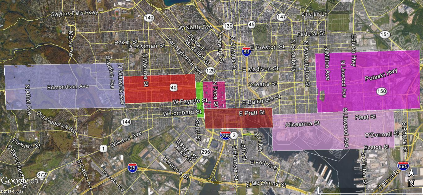 |
| SEVEN AREAS, west to east (left to right): 1-Edmondson Village to Rosemont, 2-"Highway to Nowhere", 3-MLK Boulevard, 4-Metro West/Lexington Market 5-Pratt St./Inner Harbor, 6-Southeast Waterfront, 7-Hopkins Health Corridor to Bayview |
Red Line planning can be divided into seven city areas, each with a different status and context for how change can take place. A primary reason the Red Line died was because it was an all-at-once project. Area plans were expected to serve the Red Line project, when it should be vice-versa.
To proceed forward, here's a review of where the seven planning areas stand, west to east. (Anyone looking for my proposals can find them everywhere else in this blog.)
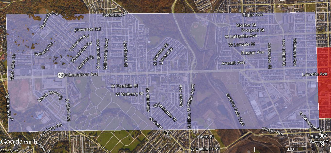
1- Edmondson Village Corridor
 |
| AREA 1 |
Along Edmondson Avenue (US 40) and westward into the suburbs, the Red Line plan has no fatal flaws. The basic design work has been completed. There are indeed flaws, many significant but none fatal, so all that's needed are tweaks. The alignment is also amenable to being built in phases to match the fiscal and political conditions.
Various plans for the area, most notably the new Uplands neighborhood, are not contingent or waiting on the Red Line. More housing challenges also await. The neighborhoods are generally attractive, but the housing facing Edmondson Avenue, cheek-by-jowl with its extremely heavy traffic, is deteriorating badly. Cramming in the Red Line would only make this worse. A solution must be found, because this housing is what most people see, and results in a bad community image from passers-by.
Various plans for the area, most notably the new Uplands neighborhood, are not contingent or waiting on the Red Line. More housing challenges also await. The neighborhoods are generally attractive, but the housing facing Edmondson Avenue, cheek-by-jowl with its extremely heavy traffic, is deteriorating badly. Cramming in the Red Line would only make this worse. A solution must be found, because this housing is what most people see, and results in a bad community image from passers-by.
2- "Highway to Nowhere"
 |
| AREA 2 in red / AREA 3 in green / AREA 4 in mauve. |
This desolate and devastated area is a blank canvas. The Red Line design in the highway median is close to completed, but the surrounding area is virtually free of constraints. Tweaks won't help much, like the city's recently announced Fulton Avenue bike loop along the top rim of the highway (The Sun, April 29, page 2). Something much bigger must be done - so big that it needs to dwarf the Red Line plan itself, which would only play a significant but supporting role.
The basic problem with the "Highway to Nowhere" is that it is what Jane Jacobs described as a "border vacuum" - a "no-man's land" that is not amenable to any new growth or development. A mediocre regional rail line like the Red Line would not make it any better or more attractive.
The basic problem with the "Highway to Nowhere" is that it is what Jane Jacobs described as a "border vacuum" - a "no-man's land" that is not amenable to any new growth or development. A mediocre regional rail line like the Red Line would not make it any better or more attractive.
Throughout the long Red Line process, the city was adamant about keeping the "Highway to Nowhere" open, even as they repeatedly closed it for months at a time for various construction activities, without significant adverse impacts. The highway hypocrisy seems endless. Get rid of it!
3- MLK Boulevard Corridor
The Red Line's "Locally Preferred Alternative" - the favored plan resulting from the federal alternatives analysis - was originally supposed to locate the line along Martin Luther King Boulevard, southeast between the "Highway to Nowhere" and downtown. Then the Red Line's engineering phase determined that the portal to the downtown tunnel could not be built along this route, and the alignment was moved to extend the downtown tunnel under Fremont Avenue.
Now that the downtown tunnel is dead, it is a simple matter to move the Red Line alignment back to MLK Boulevard, where it was in the first place.
This would be an impetus to redesign MLK Boulevard in order to re-integrate areas which are now divided between downtown and West Baltimore, most notably the University of Maryland downtown campus and biotech park. MLK Boulevard was originally designed more like a mini-expressway that divides the communities rather than like a classic grand boulevard which unifies them. The University and its medical center lost both of their stations during the Red Line planning process, and this is an opportunity to replace them.
4- Metro West/Lexington Market Area
 |
| AREA 3 in green / AREA 4 in mauve / AREA 5 in brown. |
The Lexington Market Metro Station was the planned termination point for the west rail line from the 1960s through the 1990s, until the 2002 regional rail plan which originated the Red Line.
The original plans were based on the common assertion that all successful modern urban rail transit systems have a central hub. At first, this was supposed to happen at the Charles Center Metro Station.
Now it increasingly appears that this hub must be at the Lexington Market Metro Station instead. Events since the 1980s have conspired for this. First, the central north-south light rail line was built on Howard Street, only a block away. Then the Red Line was conceived as a disconnected east-west through line instead of west-only.
In the last two decades, downtown itself has drifted eastward along the waterfront, most notably to the "new downtown" at Harbor East. Then within just the past few months, the Port Covington light rail spur from the central line was announced (after I proposed it). So not only is downtown drifting, it is also dispersing.
The need for a tight efficient downtown rail hub is as important as ever to integrate the transit system, but locating that hub at the center of downtown is no longer very relevant, because there is no longer really a "center of downtown" anymore.
The west side of downtown urgently needs attention. The massive six-square block Metro West office complex formerly occupied by the Social Security Administration is now empty, the "superblock" project has been officially pronounced a failure, and yet another new attempt to arrest the long decline of the Howard/Lexington area has begun.
The west side of downtown urgently needs attention. The massive six-square block Metro West office complex formerly occupied by the Social Security Administration is now empty, the "superblock" project has been officially pronounced a failure, and yet another new attempt to arrest the long decline of the Howard/Lexington area has begun.
The Lexington Market Metro Station is only four blocks east of MLK Boulevard. Many alternatives are possible, on the surface or in a short tunnel, terminating or continuing, wherever and whenever.
5- Downtown and Inner Harbor Surface Streets
The Red Line Draft Environmental Impact Statement studied many alternative variations using downtown surface streets. As a group, the cost-effectiveness scores of these alternatives were far better than the "preferred" tunnel plan, which was seemingly chosen only for political reasons that somehow made sense to someone at the time.
The basic surface alignment concept was to use Pratt and Lombard Street between MLK Boulevard and Market Place, then proceed eastward on Piers 5 and 6 in the Inner Harbor to Harbor East. It would be a simple matter to dust off, revive and refine these plans.
What the Red Line plans never really recognized was that such a surface light rail plan could essentially become the core of a streetcar system, which could then be extended in any or all directions. Thus this plan would have value far beyond just serving the Red Line. At the time, the many streetcar advocates were torn between promoting this fact and promoting the underground Red Line plan, which would essentially preclude such a surface plan.
Surface rail transit has many obvious advantages. It is highly visible, it can be integrated into its urban environment and can have more convenient stations.
Surface rail transit has many obvious advantages. It is highly visible, it can be integrated into its urban environment and can have more convenient stations.
6- Harbor East to Canton Waterfront
 |
| AREA 6 |
Streetcar lines such as this, as well as in other areas such as Charles Street and the Mount Clare Corridor, would use the light rail Red Line as a central trunk, and proceed from there.
As such, it should be studied as part of a comprehensive streetcar system planning process that would pick up where the Red Line leaves off. Various streetcar corridors were compete with each other for priority (such as a North Avenue line recently touted by Republican mayoral nominee Alan Walden).
Careful attention in streetcar planning must be paid to the traffic and street environment of the lines. Streetcars emphasize shorter trips rather than longer regional trips, where there slow speeds are less of an issue. They are also as much of an urban design and community planning solution as they are a transportation solution.
Careful attention in streetcar planning must be paid to the traffic and street environment of the lines. Streetcars emphasize shorter trips rather than longer regional trips, where there slow speeds are less of an issue. They are also as much of an urban design and community planning solution as they are a transportation solution.
The transportation role of streetcars is very similar to that of circulator buses, which can be easier to implement for the shorter term.
7- Hopkins Health Corridor to Bayview
 |
| AREA 7 |
In the recently completed 2040 regional transportation plan prepared by the Baltimore Metropolitan Council, the Red Line is gone, but a one-mile extension of the Metro underneath Broadway from Hopkins Hospital to North Avenue remains an active part of the plan.
A Metro extension beyond Hopkins Hospital should indeed be a top priority because the Metro is Baltimore's fastest, highest capacity and highest quality transit line, and urgently needs a viable terminal station which can serve as a feeder hub for the bus system.
But this Broadway Metro extension has three serious fatal flaws: (1) The state already engaged in a full federal environmental impact study process for this line and found it was not even close to being cost-effective, (2) It can't be extended beyond North Avenue, at least not in the even remotely foreseeable future beyond 2040, and (3) It wouldn't connect to the MARC commuter rail system, the plan having been quietly scuttled for a station at Broadway which is in an extremely constrained segment of the Amtrak corridor.
So it's back to the drawing board. A far more promising alignment for a Metro extension beyond Hopkins Hospital would be eastward along the Amtrak corridor, eventually toward Bayview, Dundalk, Middle River and White Marsh.
This area, between the main Hopkins Hospital campus, biotech park, and Hopkins Bayview - where redevelopment is already moving fast - could be dubbed the Hopkins Health Corridor.
In Sum...
That's it. Mix or match. These area plans are the building blocks for a new workable Red Line plan. It could include some or all of Area #1, along with plans for Area #3 or Area #4, with Area #2 serving to link them together. The rest can be weaved in over time.
It's not a matter of one plan versus another. The MTA's Red Line plans can be salvaged in smaller phases. Let's get to work.