
THE INTERCHANGE THAT NEEDS TO BE MADE INTO A NEIGHBORHOOD
The biggest problem with planning in Baltimore is that people are always obsessing and fighting over the same old pieces of land while huge swaths remain unclaimed wastelands. We’re still trying to get things exactly right in places like the Inner Harbor, Fells Point and Roland Park, constantly revisiting plans that were realized decades ago, instead of moving on to other places that are quietly crying for attention.
The transit Red Line, billed as Baltimore’s biggest project ever, typifies this. The biggest and most expensive fights are brewing in the established areas of Fells Point and Edmondson Avenue, while the forlorn Franklin-Mulberry corridor is merely seen as the “easy” part - the path of least resistance.
And even in the Franklin-Mulberry corridor, the worst and most neglected parts are not located in the infamous “ditch”, the linear eleven block area between Schroeder and Pulaski Streets where the highway remnant is surrounded by giant retaining walls that separate the communities. The rawest, most untreated and infected scars are the areas just beyond the ditch where retaining walls do not and cannot physically contain the blighting influence.
The biggest, most imposing and most treatable of the urban cancers infecting an area just beyond the “ditch” is the horrible interchange of Martin Luther King Boulevard and the Franklin-Mulberry Expressway (FMX). This is the single largest remnant of the huge proposed urban expressway system proposed in the 1960s and 70s that was actually built. Everyone seems to have put it out of their minds, but it is still out there, larger than life, and is still thwarting urban progress everywhere around it.
The Franklin-Mulberry Corridor - Consisting of the eleven block “ditch” between Pulaski and Schroeder, the MARC station on the west (left) end and the MLK Interchange on the east (right) end. Downtown is just beyond the photo to the right.

The Franklin-Mulberry Corridor - Consisting of the eleven block “ditch” between Pulaski and Schroeder, the MARC station on the west (left) end and the MLK Interchange on the east (right) end. Downtown is just beyond the photo to the right.
The most insidious problem with the MLK/FMX interchange is that we’ve learned to live with it, like a sleeping giant that we don‘t dare to wake up. Just to the north, we’ve built the lovely Heritage Crossing community of incongruously low density semi-detached homes on large leafy lots. Heritage Crossing has a giant green earth berm separating it from the interchange. A plausible case was made for the very low density housing of Heritage Crossing, because it created a very desirable yet economically viable community in a location where hardly anyone had previously wanted to live. This was done despite the outspoken objections of low income housing advocates who pointed to the dire need for more rather than less housing in the inner city.
So the low density of housing in Heritage Crossing can perhaps be justified, but the huge earth berm that insulates the community from the interchange has no value for housing, recreation or any other use. It is a horribly unjustifiable waste of valuable inner city land, which serves only to cut off the community from its surroundings.

The FMX interchange from MLK Boulevard. The Franklin-Mulberry expressway is above. The housing and gazebo of Heritage Crossing are barely seen behind it.

The FMX interchange from MLK Boulevard. The Franklin-Mulberry expressway is above. The housing and gazebo of Heritage Crossing are barely seen behind it.

Heritage Crossing - This ought to be a downtown neighborhood
Seen from Heritage Crossing, the masterful way that the urban designers related the community to the earth berm lulls us away from realizing the incongruity of it all. The interchange is totally invisible behind the berm in the photo above, which illustrates the relationship between the housing and the community’s focal point, a lovely gazebo park. Just a small piece of the earth berm is visible behind the gazebo and to the right of the housing. This photo, with its skyline overlook, makes Heritage Crossing look like it should be a community on the edge of downtown, with million dollar homes for top downtown executives. But Heritage Crossing has had no catalyst effect. There are still hundreds of bombed out rowhouse carcasses just a few blocks away. The community's isolation is ironically caused by the same freeway interchange earth berm that makes it livable.
The tall downtown building in the background is governed by the same need to isolate the interchange. This is part of the huge downtown Social Security Administration complex that encompasses four square blocks bounded by MLK Boulevard and Franklin, Greene and Saratoga Streets - a footprint that is larger than any other single downtown development site, including the arena and convention center, and which rivals Oriole Park at Camden Yards.

Downtown Social Security Administration's huge secret "courtyard"
The downtown Social Security complex was designed to be a giant barrier to cut downtown Baltimore off from the MLK/FMX interchange, which in effect also cuts off downtown from the rest of northwest Baltimore. There is a huge vacant lot behind the high rise building, encompassing well over a square block, which is land locked by the east and westbound lanes of the Franklin-Mulberry expressway. This apparently useless lot is as dead as a doornail. The photo above was taken up against the concrete wall that hides the lot from MLK Boulevard. There are also walls separating the lot from Franklin and Mulberry Streets behind the landscaping on the left and right sides of this photo. It is hard to believe that such a vast secret place could exist right in the midst of downtown Baltimore.
Across Mulberry Street is a large fenced daycare playground for the kids of Social Security workers, flanked by large fenced parking lots with security guards. (Yes, I was given the third degree by the guard who strongly implied that taking photos was illegal and could land me in some place like Gitmo.)
All this has the effect of severely interrupting the flow of downtown activity. The only active uses supported from this part of MLK Boulevard are a freestanding Rite Aid drugstore southwest of Mulberry and a large self-contained garden apartment complex northeast of Franklin, both of which look virtually indistinguishable from their counterparts in the most sprawled-out sectors of outer suburbia.
This resemblance to outer suburbia is the only thing that makes sense in this area. Unfortunately, the rest of Baltimore’s inner northwest neighborhoods, including Lafayette Square, Harlem Park and Upton, are not so easy to adapt. These communities are cut off from downtown by the interchange, leaving them vulnerable and struggling.
TRAVEL PATTERNS
TRAVEL PATTERNS
The Maryland Transit Administration can’t be blamed for avoiding putting a transit station on their proposed Red Line at this dead location, but the City should not be so quick to write it off and accept death. There is great opportunity here.
The most striking aspect of the travel patterns at the MLK/FMX interchange is that they are oriented almost totally to through rather than local traffic. This is just a small bad sample of what could have happened around the entire perimeter of downtown Baltimore, especially along the waterfront in the Inner Harbor, if the full 1960s expressway system had ever been built. Whew… disaster averted.
But the City still hasn’t fully faced the fact that there are simply no viable routes for predominately through traffic anywhere within the city limits - except for the two harbor crossings, Interstate 95 and 895. The short 1.5 mile Franklin-Mulberry Expressway is part of U.S. Route 40, which extends all the way from New Jersey to Utah. However, this traffic has been increasingly displaced by local traffic within the city limits, most recently by the massive expansion of the Hopkins Hospital complex along Route 40 in East Baltimore, which is being built with major new monster parking garages but absolutely no increase in roadway capacity.
Martin Luther King Boulevard was originally envisioned as a large north-south bypass for through traffic around the western perimeter of downtown, but this is also a myth. While parts of it (such as this segment at Franklin-Mulberry) are extremely wide, with enough condemned land to have built a full-fledged freeway, many design corners were cut which resulted in traffic flow bottlenecks. It is virtually impossible to coordinate the traffic signals efficiently at the major MLK intersections, which have complex conflicts between the various queues and turning movements. The north end of MLK Boulevard near Howard Street is particularly intractable.
The City still has a plan on the books, documented in the Long Range Regional Plan of the Baltimore Metropolitan Council, to extend MLK northward all the way to the Jones Falls Expressway. However, this has never seemed to be feasible with respect to either traffic operations or politics, and now looks to be virtually impossible with the University of Baltimore expansion now underway onto the Mount Royal/Bolton Yards site which flanks the JFX.
So the current MLK/FMX interchange was designed for a highway system that does not exist and never will, and has turned that section of the City into something that we don‘t want. The best thing to do would be to try to redirect as much through traffic as possible to Interstate 95 and the Fort McHenry Tunnel. Of course, there is a limit to this, as there is for any route, but the current interchange force feeds bad traffic patterns.
The segment of MLK Boulevard south of Franklin-Mulberry, feeding into I-95 and the Baltimore-Washington Parkway, could take advantage of a higher capacity, but the segment to the north cannot. The FMX itself, alias “the road to nowhere” or “the ditch”, has a gigantic traffic capacity, and would have more than enough even if it was narrowed from six to four lanes to make more room for new development and the Red Line. Any free flow traffic lane is capable of carrying twice as many vehicles or more relative to a normal surface street controlled by traffic signals. So narrower expressways can carry more traffic than much wider surface streets. Tight interchanges, with ramps located close to the mainline, are also efficient because they do not take a long time to clear the traffic between intersections. Expressways do not need to be wide to be efficient.
MLK Boulevard south of Mulberry could be reconfigured to take advantage of this. Express lanes could be located on the west side of the right-of-way, away from downtown and the University of Maryland, while a local service road could be located on the east side. The road is already set up this way south of Pratt Street adjacent to Ridgely’s Delight. It may also be desirable and warranted to build underpasses for the express lanes underneath the major east-west streets, especially Pratt and Lombard. This was seriously considered as part of the original plans back in the 1970s, and its time may have finally come. Segregating and isolating the through traffic would be good for pedestrians, the transit orientation and the street environment.
In sum, the MLK/FMX interchange should be wiped out and replaced with something that suits the desired traffic patterns, creates far less impact on development patterns, and takes up a lot less space.
CREATING A NEW DOWNTOWN NEIGHBORHOOD
The most important objective is to wipe out the nasty interchange of MLK Boulevard and the Franklin-Mulberry Expressway, and replace it with a brand new transit-oriented neighborhood that allows the northwest part of downtown to flow seamlessly from the University of Maryland into Heritage Crossing.
The most likely MTA Red Line plan is to run the line from “the ditch” west of MLK, then toward the south on MLK. It thus makes sense to create a new highway alignment parallel to this Red Line alignment, creating a new west-to-south corridor serving both.

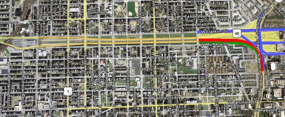
The New Neighborhood - between Heritage Crossing to the north, and the Red Line and Franklin-Mulberry Expressway to the south.
In the aerial photo above, such a corridor is shown as a red line for the Red Line (that makes sense, right?) and a parallel green line for a narrowed four lane expressway which would channel through traffic between the Route 40 West corridor and MLK to the south, toward I-95. This new alignment would cut through the lot to the southwest of the existing interchange which would take out the free-standing Rite Aid drug store, which could easily be relocated.
A tight new partial or full FMX interchange could be built at the Schroeder Street bridge over the ditch, located at the west (left) end of the photo. Franklin Street, the straight east-west blue line just north of that, could be made into a two-way street to connect to MLK Boulevard to the north. Saratoga Street would connect to the diagonal street shown, also creating an easy way to connect to the eastbound downtown street, Mulberry Street. This diagonal street would also be oriented directly to the Red Line, which would be a great spot for a transit station.
Best of all, this configuration would enable the city to get rid of that awful interchange. By doing this, all of the land shown in yellow, well over six square blocks, would be opened up to create a great new transit oriented community. And as if to cater to anyone with a flat imagination, the land created here would be mostly flat, unlike the infamous ditch to the west.
This new urban district would have no shortage of great identities. To the north of Franklin Street, the Olmsteadian identity would be established by Heritage Crossing. The earth berm would no longer be needed to buffer the quiet low density neighborhood, so it could be replaced by higher density, more appropriately scaled urban development to achieve a transition between the existing and the new. Heritage Crossing would become something it urgently needs to become - a downtown neighborhood.
To the southwest of Saratoga Street, this new district would be contiguous with the University of Maryland’s downtown campus. So the new district would be a college town. I’m feeling smarter already.

Pine Street - Looking north from the University of Maryland to the New Neighborhood north of Saratoga Street
This college linkage is depicted in the photo above, taken from Pine Street looking northward toward Saratoga. Pine Street serves as a service drive for MLK Boulevard through the University of Maryland campus. The beautiful campus police building - historic and oozing-with-character - sets the tone for how the street system could look throughout the new neighborhood. Pine Street would then extend northward from Saratoga to Mulberry and Franklin via the new diagonal street that would run adjacent to the Red Line. Another new north-south street could be created through the landlocked Social Security complex, to fill in the downtown street grid and eliminate the oppression of the unmanageable “superblocks” that now isolate this complex.
Most fortuitously, the Social Security Administration has announced that it plans to vacate this giant complex. According to the federal General Services Administration, as reported in the October 14th Sun, this facility has been deemed “obsolete”. Automation has reduced the Social Security workforce at this site to less than half its previous maximum. The Feds could sell or lease these buildings to a multitude of tenants who would establish a much more varied and vital daytime population, and the kiddie playground could be made part of a normal park instead of a fenced security compound.
The residents of Heritage Crossing could then even feel free to use the playground, and in return, the new residents, students and office workers could take a nice occasional stroll over to the Heritage Crossing gazebo.
This entire new downtown neighborhood would become the eastern anchor for the vitalization of the entire Franklin-Mulberry corridor, and indeed, the badly needed anchor of the corridor radiating outward from downtown into all of northwest Baltimore. If this area was transformed from an interchange to a neighborhood, we should even be able to convince some downtown executives and college professors to live there.
I'm hoping the buildings and parking garages are torn down. In its place could be an extension of this neighborhood you're proposing. Not only will it help the neighborhoods to the west but the Westside of Downtown to the east. It could be another State Center type project.
ReplyDeleteThank you so much for taking the time for you personally to share such a nice info. I definitely enjoying every little bit of it. It is a great website and nice share. Inbloom Design is one of Sydney's Retaining wall, retaining walls landscape design specialists throughout Sydney.
ReplyDeleteHey, It really is incredibly fantastic and informative website. Good to discover your site Very well article! I’m simply in love with it. Ashwini Homoeopathy is leading homeopathic clinic in India, Specialising in treatment of Advanced diseases as Cancer.
ReplyDelete--------------------
Homoeopathy Center in Vashi