WESTPORT: PROTOTYPE FOR BALTIMORE'S FUTURE EDGE CITIES

Patrick Turner's billion dollar-plus Westport project should be fundamentally different from other recent mega-developments in Baltimore, and not just because of its size and its planned 65 story anchor, but because of the way it points out how things will need to be done in the future.
The fundamental difference is that Westport will absolutely need to be fully oriented to its adjacent station on the central light rail line, and not just because its there, but because the development will simply be too large and dense to provide sufficient access from its limited network of narrow local streets. New Westport residents, workers and visitors will need to rely on the light rail line to get them to and from the airport, downtown and Camden Station, to provide them with their lifeline to the world.
 Looking west on Wenburn Street from underneath the light rail line toward the Baltimore-Washington Parkway. Narrow little Wenburn is the only street which connects directly from the future edge city of Westport to the B-W Parkway.
This points to a little recognized transit truth. Most people do not use transit because they want to. They use transit because they need to. Most New Yorkers and Londoners would not use their local subways if they had easy highway access to work and subsidized free parking. They would become like Baltimoreans and stay in their cars.
Transit advocates like to soft-peddle transit as providing an "option" or a "choice". But when transit really is a mere matter of choice, it is usually a choice not taken. And when transit is merely a choice, there is no thundering demand from the travelling public to make it a GOOD choice, so it becomes the travel mode of last resort by folks whose lives have gotten down to last resorts.
That is the current situation in Baltimore. It is commonly accepted that we have a lousy transit system, and everyone either grins and bears it, shakes their fist at whomever, or else stays as far away from transit as they can, whenever they can.
But the denizens of the new Westport will demand that their transit be good, because it will not be a choice. And the developers of the new Westport will demand that their transit be good, because if it isn't, they won't be able to sell their community. Westport will be like Manhattan.
 Part of the future edge city of Westport as seen from the Westport light rail station. Port Covington and the Hanover Street Bridge are shown in the background beyond the Middle Branch.
This is in marked contrast to other major recent developments around Baltimore. It is ironic that the areas of Baltimore that are truly booming are the areas that have the poorest transit. Harbor East, Fells Point, Canton and the Key Highway corridor all have wretched transit access, but they have ample and mostly free parking, and this has carried them to success. Key Highway has excellent access to Interstate 95 and downtown. Canton has also excellent access to I-95 as well as I-895. Harbor East and Fells Point are becoming congested messes, but it is still far better to shuttle from your easy parking space up President Street to I-83 in air conditioned stereophonic splendor than to consider riding a bus.
On the other hand, the west side of downtown has more bus and rail transit than any other place in the region, but its redevelopment has been slow and tedious. All that transit looks like a strong asset on paper, but not where the rubber hits the road.
The whole recently identified concept of a "greater downtown" which extends all the way around the harbor and up to Charles Village is very much a response to the greater automobile orientation of downtown, which is no longer a compact place because collectively we want to drive there.
Westport must be different. Westport must use transit. There is no choice.
CHANGING THE WAY WE PLAN
Planning for Westport should be a model for future planning, and expose the deficiencies in the way we conduct transit planning to bring it more into alignment with reality as normal people see it.
Building rail transit is actually a highly regarded endeavor among taxpayers in the Baltimore region. Most people seem to like the idea of building snazzy new non-polluting rail transit systems. But Joe Taxpayer wants to build transit so that it can be used by "the other guy", not himself. He wants to build transit so that other people will get out of their cars and leave the roads, gasoline supply and carbon allotments free for him.
This is not hypocrisy. It's rational freedom of choice - the very virtue that transit advocates extol. But the transit advocates have not translated this very rational attitude into transit planning. Transit advocates still try to sell transit as something that everyone everywhere should use. We should all jump on the bandwagon of the "transit lifestyle".
The Maryland Transit Administration's 2002 rail plan introduction in the first paragraph illustrates just how little resonance this concept really has: "Imagine being able to go just about everywhere you really need to go... on the train. 21 colleges, 18 hospitals, 16 museums, 13 malls, 8 theaters, 8 parks, 2 stadiums, and one fabulous inner harbor."
This statement exploits the wishful thinking that somehow if we had ENOUGH rail transit woven throughout our entire city, that people everywhere would spontaneously liberate themselves from their cars and dedicate themselves to the transit lifestyle. But it just hasn't worked and there is no reason to believe there is a critical mass transit "tipping point" whence it will work.
For example, take the three malls that just happen to be located along the existing Metro Green Line. Mondawmin is at the point in the region's transit system that has the very best transit access of any non-downtown location, and yet its degree of transit orientation has barely been an issue in its recent major redevelopment, which will include a Target, Marshall's and many other new stores. Reisterstown Plaza has undergone similar redevelopment, and yet is as disoriented to the transit line as ever. Owings Mills was developed in tandem with the Metro from the outset, with Rouse Company's successful goal to intentionally keep the mall as isolated from the transit line as possible. There is no way these three malls are going to be anything but automobile-oriented. Because they can.
Similarly, how can a Metro extension be any kind of agent for change to the north of Hopkins Hospital toward Morgan State and/or the Good Samaritan Hospital? Being heavy rail, this line would have to be either underground, which would be expensive out of all proportion to its use, or elevated, which would be a major blight on the community. At the same time, there is no evidence that the established communities along such a line would be at all willing to undergo the necessary transformation to greater transit orientation. Where could new high density development be located in the Harford/Hillen/Perring/Loch Raven corridor? The Morgan State University campus? The little Northwood Shopping Center? The vacant woodland around Good Samaritan Hospital?
Rail transit needs Westport-type developments to ensure that the transit service is indispensable. There is no place for a Westport-style development along a Metro extension from Hopkins Hospital toward Morgan State. So this corridor will not be transit oriented. Most of the people who live, work, shop, visit and go to school there will continue to drive, even if we spend a huge amount of money and attempt to turn the community upside down to build a Metro extension.
Meanwhile, regional growth has not just stood around and waited for us during the half century that we have spent talking about building a comprehensive rail transit system, and the region will not wait for us during the coming decades either. The Baltimore region now extends far outside the Beltway, and just about all of it was built by and for the automobile.
The good news is that it is much easier to build a transit system that is focused on the areas where the majority of people will really use it. All we need to do is identify those areas.
To summarize: It is futile to plan a transit system that attempts to be all things to all people, because that will simply give more people the ability to ignore it. We must plan the transit system for major new developments like Westport, where people will use it because otherwise, there will be no Westport.
CHANGING THE TRANSIT PLAN
Here's some good news: It is much easier and less expensive to plan a rail transit system around edge cities than it is to attempt to build the kind of comprehensive system that we have failed to build (or even specifically plan for) in the past fifty years.
Attempting to successfully weave a rail transit system into existing communities is extremely difficult. In contrast, planning a rail transit system around new communities, that can be oriented to the transit system from the start, is a much more straight forward task.
In Westport, the light rail station will be the front door to the community, just as surely as the front door on a house. There is no agonizing over how to design a house to get inside it. You need a front doorway. Even in the auto-oriented post-modern world where people enter their houses intravenously though the garage and seldom have contact with their surrounding neighbors, the front door is still a very important ceremonial element. Even if two-thirds of the trips to Westport still take place via the automobile, a one-third mode share for transit would still be a quantum leap over other new developments.
Compare this to the existing communities along the MTA's two high priority rail transit lines. Route 40 (Edmondson Avenue) suffers from a major identity crisis as it cuts through the Red Line neighborhoods. It carries an ungodly amount of traffic, making the houses upon which it impinges the least least desirable in the neighborhood. Rognel Heights, Edmondson Village and the other neighborhoods in the Route 40 West corridor are actually very attractive, but you would never know it by the front that is presented on Route 40. Its like a very nice house with a very repugnant front doorway.
Building an attractive rail transit line along Route 40 through such a community is almost impossible. Most obviously, with seven lanes devoted to overwhelming traffic, there simply isn't enough room to fit it in and build it right. The plan will probably call for widening the street still more, placing it even closer to the houses that are already far too close to the road for comfort. The transit line would then be stuck into the median strip, where riders would have to confront the traffic to get there, and then feel like they are drowning on a tiny lifeboat in a sea of traffic while waiting for the train.
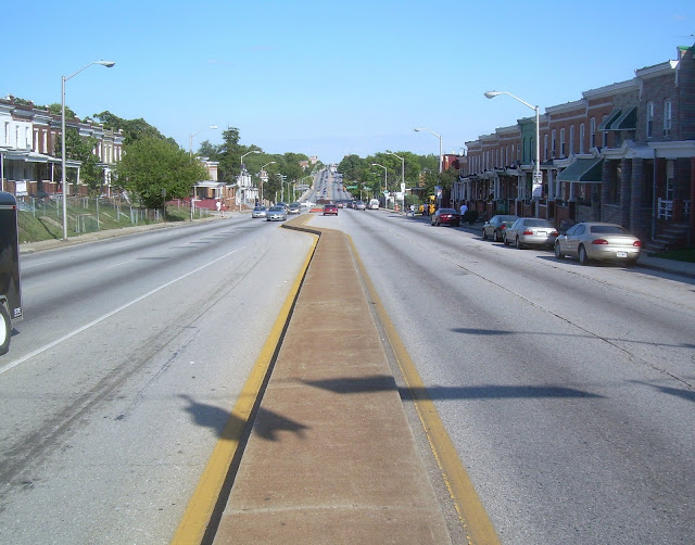 Edmondson Avenue (Route 40) looking east, proposed MTA location for the Red Line. Obviously, the four foot median strip is not wide enough for a rail transit line, so widening would have to take place. The houses to the right are right on the sidewalk, so the widening would have to cut into the small hill on the left which separates those houses from the seven lanes full of traffic. The current relationship between the houses and the congested traffic is bad, and adding a rail transit line wouldn't make it any better.
The existing situation is actually much better for residents, most of whom live on the side streets away from Route 40. They can at least wait for the bus along the sidewalk where there is at least a tenuous connection to the community. Many of the buses turn off of Route 40 onto Wildwood, Woodington, Old Frederick and Caton Avenue, where patrons are able to wait for the bus in quieter, more civilized and more convenient locations. Or, for those residents with access to a car, the preferred alternative is simply to drive.
Many residents of the Route 40 neighborhoods believe that the Red Line is being planned for "somebody else", not for them. As previously discussed, this is common to transit planning - let the other guy take transit, not me.
The situation is even worse in the Green Line corridor extension north of Hopkins Hospital. Here the transit planners must deal with the straitjacket imposed by the fact that the line must be heavy rail, with absolutely no contact with its surrounding environment. Heavy rail employs an electric "third rail" which must be kept away from everyone at all times, necessitating that the transit line be either underground (unthinkably expensive and disruptive), fully fenced off (impossibly impractical, especially at intersections), or elevated (very ugly and inconvenient).
No one has come out and promoted any these bad alternatives.
Meanwhile, we are talking about a community that has already existed without a rail transit line for about 60 to 70 years and has already fully developed all its ways of moving around without rail transit. Sure, there will be some people who will embrace the new "choice". But like any other choice, rail transit will be a "take it or leave it" proposition, and most people will leave it, because they can and already have.
Transit planning around new edge cities is far easier and more straightforward. There is no imperative to provide transit everywhere, because development can be focused on the "front doorway" that is the transit station. In contrast, there will be pressure to maintain the existing costly bus service on Red Line streets like Wildwood Parkway and Green Line streets like Loch Raven Boulevard, thus creating redundant service that will undermine the ridership and efficiency of the new rail line.
Development can be organized and designed in such a manner to strengthen the front door transit station. Unlike the Red Line's Edmondson Avenue, which is home to the least desirable housing, and the Green Line's Hillen Road, where most of the houses and Morgan State campus turn inward away from the street, edge cities along transit lines can be oriented with a "clean slate" to create the optimum relationship between development and transit.
View Larger Map Click on this web link or on the controls above to zoom and pan on this map to see details of this rail transit plan and its satellite image.Here is a Google Map showing a very modest expansion of the regional rail transit system, much less than what the MTA proposed in their 2002 plan as being "high priority". This plan is oriented around two more major new edge cities in Baltimore City, along with intimate new connections to the rest of the regional rail and MARC commuter rail systems, as described below.
CANTON-BAYVIEW: EDGE CITY #2
The Canton-Bayview corridor in East Baltimore is already booming with new construction, although right now it is almost totally automobile oriented, with easy access to I-95 and I-895 and huge acreages for parking reclaimed from former industrial wastelands. If we want to make sure that the future is oriented to transit and not cars, we'd better act fast. If we do not act soon, the future will be limited to the amount of traffic that can be accommodated on the local streets and much of the growth potential will be used to maintain the space for cars instead of people.
The southern and northern anchors of Canton-Bayview are already in place, but there is a huge amount of development potential in between. Anchoring the south end, we have the First Mariner Tower on Boston Street in Canton Crossing. At the north end, we have the National Institute of Health on Lombard Street in the Hopkins Bayview Research Park. In between is a huge swath of developable land and three extremely charming neighborhoods - Brewers Hill, Highlandtown and Greektown. Lots is already happening, the Brewers Hill Natty Boh complex being the most significant. The Crown Cork and Seal Building appears to have the most architectural potential. It is located right next to Ed Hale's trucking company which is already slated for high density housing.
Another key parcel is the Maryland Transit Administration bus storage and maintenance facility, located squarely between Greektown and Bayview on Oldham Street. What could be more fitting than putting transit-oriented development on a parcel of land owned by the transit company?
Running along the entire north-south length of the Canton-Bayview edge city is an unused railroad right of way that would be perfectly suitable for an extension of the Green Line Metro from Hopkins Hospital. At the north end of this right of way, a MARC commuter rail station could be built to connect to the Green Line for commuting to and from Washington, DC, Aberdeen, Fort Meade and points in between.
But planning for such a Metro extension needs to begin very quickly so that development of the edge city does not get too far ahead of the transit planning. Once too much of the new development becomes tailored to automobile access, it will be very difficult to retrofit it for a transit orientation.
 The very begining of the skyline of the future Canton-Bayview edge city, looking west from the Hopkins Bayview Research Park. In the left background is the First Mariner Tower at Boston and Conkling Streets, proposed terminus of the Green Line Metro extension from Hopkins Hospital. In the center background is the Natty Boh Tower in Brewers Hill. The more horizontal building to the right of that is the Crown Building. The Highlandtown Metro Station would be just behind that. Greektown is in the foreground, with a small bit of the MTA bus storage yard on the right.
Unfortunately, the MTA seems to think this whole idea of a Metro Green Line extension to Canton-Bayview is dumb. They prefer an extension to Morgan State and/or Good Samaritan, which would be far more expensive, far more physically disruptive, and have a much lower ridership potential. The MTA appears to be oblivious to the potential in Canton-Bayview for billions of dollars in new development tailored specifically to transit, and they prefer the idea of building a transit line to Canton on slow local surface streets amid all the existing traffic congestion.
FRANKLIN-MULBERRY:
EDGE CITY #3
While the proposed Red Line is fraught with problems along and beyond the Edmondson Avenue corridor as discussed above, it can work perfectly in the Franklin-Mulberry Corridor between downtown and the West Baltimore MARC station. This is where it would intimately serve the proposed Franklin-Mulberry edge city.
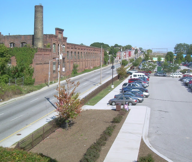 Looking east from the West Baltimore MARC Station along Franklin Street. The Franklin-Mulberry edge city would extend for approximately 1.4 miles eastward from this point. All the Route 40 expressway traffic could be consolidated to the south edge (toward the right in this photo) of this corridor, in the area now used only for the eastbound expressway lanes, without any overall decrease in traffic capacity or increase in delay. This would leave plenty of room for the new transit line connected directly to transit-oriented development in what is now the westbound expressway lanes, connected to Franklin Street. The building shown to the left is the Ice House, a perfect structure for adaptive re-use once the MARC station is upgraded and Franklin is converted into a local street.
Building only this portion of the Red Line which serves the 1.4 mile long edge city would have numerous benefits. The edge city would essentially be an extension of downtown and provide a huge anchor for the greatly needed redevelopment of the west side. The new development would also be extremely accessible to the MARC line for connections to and from Washington, DC, the military base relocations at Aberdeen and Fort Meade and intervening points.
Concentrating the dense new development in the Franklin-Mulberry corridor would also allow the surrounding communities such as Lafayette Square, Harlem Park, Rosemont, Penrose and Franklin Square to attain stability based on retaining and renovating the existing housing stock.
The MARC Station and Red Line terminus would also be an ideal location for a comprehensive transit hub serving all the bus routes in the west side of the region.
A very short rail transit line would thus have very large benefits, in creating development opportunities and organizing the structure of the regional transit system. The success of the Franklin-Mulberry edge city could demonstrate the power of transit-oriented development in an area that has seen very little development for decades, and provide an impetus for further extensions of the transit system and more transit-oriented edge cities.


