TRAFFIC PLANNING 101I think it's time for a little lesson in elementary traffic planning. I hope you find this useful.
The following does not address the tools of so-called "traffic calming" such as speed humps, rumble strips, chokers and
diverters, that tend to harass drivers into submission. They may have their role, but if we get the basics right, their role will be much less.
The big lesson is that there is no need for big confrontations between traffic and people. What is best for traffic conforms very nicely to what is best for people.
Here's what Baltimore needs to do:
KEY #1 - MAKE THE BUSY STREETS AND HIGHWAYS AS BUSY AS POSSIBLE
Some roads should be assigned to carry as much of the total traffic load as possible, so as to give the rest of the street system as much relief as possible. The roads at the top of the hierarchy should do it by attracting the traffic that is travelling the longest distances and by providing relatively little access to adjacent land. This is a dirty job, but some roads need to do it.
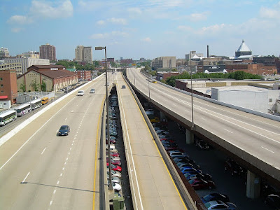
A clear-cut example of this is the Jones Falls Expressway (
JFX) and adjacent
Guilford Avenue and
Fallsway (photo above). The expressway's status at the top of the hierarchy is pretty obvious. It carries mostly longer distance traffic and provides access only at interchange ramps.
Busyness is expressed in terms of the flow rate - vehicles per hour. On highways like the
JFX, the more vehicles the better. Flow rate is NOT a measure of congestion. When highways are congested, they carry much less traffic flow than when they are steadily moving. The flow rate of the
JFX is generally highest north of 29
th Street. It is much lower nearer to downtown, as shown in the above photo, which indicates a failure of traffic planning to optimize traffic patterns.
Guilford Avenue and
Fallsway should be one step down in the hierarchy (respectively to the left and right of the expressway in the photo above). These streets are oriented to serve the expressway ramps and other
thru traffic much more than the adjacent buildings, such as the prisons (to the right on
Fallsway) and the rears of the
Sunpapers, Downtown Athletic Club, State Highway Administration and other buildings beyond (to the left on
Guilford), which are all oriented away from the street.
The street hierarchy proceeds downward from there. While it is important that the expressway and the adjacent
Guilford and
Fallsway carry as much traffic as possible to relieve nearby parallel streets such as Calvert, St. Paul, Charles, Cathedral and Park of this burden, all of these streets need to be slotted in the hierarchy.
Charles Street needs to carry a very high traffic load simply because there are many big important buildings directly oriented to it, and also many buses that cannot use the higher hierarchy streets like
Guilford because that would be very inconvenient and unattractive for the transit patrons.
Streets like Charles must perform a very careful balancing act, whereby they simultaneously serve a lot of cars, a lot of buses and a lot of pedestrians. Every piece of pavement must be accounted for and serve maximum duty in this balancing act, both in space (street lanes) and in time (traffic signal timing).
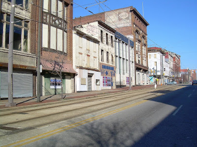
If any of these three groups - cars, buses or pedestrians - is not well accommodated, a very important street like Charles would lose a lot of its vitality. This is what has happened on Howard Street, as sadly shown above. Once upon a time, planners decided that Howard Street would be better off if cars were banned from part of it, first for a bus mall and later for light rail. The retail district still hasn't recovered from the consequent loss of vitality and exposure.
KEY #2 - MAKE LOCAL RESIDENTIAL STREETS AS QUIET AS POSSIBLE
When busy streets are made as busy as possible by attracting the maximum share of the traffic load, local streets can be made as quiet as possible. Such streets should have definite cues to alert motorists that they are not in the realm of maximum traffic flow, but are instead guests in
somebody's neighborhood. Local streets should serve as the calm foreground and backdrop of urban life. Unfortunately, inner city Baltimore has precious few of these streets.
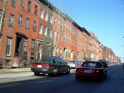
This lack of true local streets is a direct result of inefficient traffic planning: The more traffic that can be carried on the streets which ought to be busy, like
Guilford and
Fallsway, the less traffic needs to use the parallel residential streets like Calvert, which is only one block away (shown above). Unfortunately, the City has not done this. Residential Calvert Street currently carries much more traffic than non-residential
Fallsway. The blank impenetrable prison walls on
Fallsway enjoy more solitude from traffic than do the Victorian front doorways on Calvert Street.
KEY #3 - GET TRAFFIC TO GO ABOUT 30 MPH
Traffic should not be encouraged to go as fast as possible. Contrary to popular belief, more vehicles are NOT accommodated when they are free to go as fast as they want. On most streets and expressways, the speed at which the most traffic can be accommodated is about 30 miles per hour.
When speeds are either much faster or much slower than 30 mph, motorists find that they must maintain longer gaps between their vehicles, measured in seconds. At about 30 mph, gaps of about 2 seconds between vehicles can usually be safely maintained. At either higher or lower speeds, the gaps must become longer than that, and in either case it can get very unstable. It is not uncommon for gap times between vehicles to be similar at 10 mph to what they are at 60 mph - say, 3 seconds. It is physically impossible for any street or expressway to carry a flow of 1800 vehicles per hour per lane with gaps as long as 3 seconds between vehicles (3600 seconds in an hour divided by 3 seconds per vehicle equals a flow rate of only 1200 vehicles per hour). The result? Traffic slams to a halt. The gap time thus becomes infinite, and the resultant traffic flow rate becomes zero. That is not good for anybody.
The great philosopher Yogi Berra may have said it more eloquently: "No one goes there anymore because it's too crowded." When there is congestion, there is less flow despite bumper to bumper traffic, so no one can go there anymore.
Under heavy traffic conditions, motorists should be encouraged to deviate as little as possible from about 30 mph.
(Clarification 3/1/07: 30 mph is an approximation. Local conditions are still the most important determinant in setting traffic speeds. 25 mph is often more suitable than 30 mph, especially on streets where very heavy traffic loads should not be carried. Thank you Richard Layman, for calling attention to this.)
KEY #4 - TIME THE TRAFFIC SIGNALS FOR SHORT GREENS AND SHORT REDS
Traffic signals are necessary wherever there are major conflicting vehicle and/or pedestrian movements. Traffic signals almost always reduce the capacity or maximum flow rate of an intersection compared with locations without traffic signals. The easiest capacity losses to quantify are those caused by signals changing from green to yellow to red and back to green, but these are not the worst capacity losses.
What's worse is when traffic backs up from one intersection to the next. This is generally caused by excessively long red lights. A capacity loss also occurs when a signal is green but the next one upstream is not feeding traffic, so the green time is wasted. This is caused by excessively long green lights.
You know there is too much green time when you look down a street and see a long string of green lights at successive intersections. The only way traffic can benefit from that kind of pattern is to go fast enough to get through all the intersections on green. But we know that capacity is wasted whenever traffic goes faster than 30 mph (Key #3), in addition to the fact that speeding traffic is a hazard and a nuisance.
A long string of green lights also tend to turn red in quick succession, so only a small minority of the vehicles can get through all the lights on green. That translates to even more loss of traffic capacity.
Finally, long green lights simply require longer red lights, which means longer delays and longer backups that block the upstream intersections, which causes still more capacity loss.
So whatever might be gained from having fewer green-to-yellow-to-red-to-green signal transitions is more than offset by the delays, blockages, speeding and capacity losses of those long greens and reds.
Baltimore has some of the longest greens and red lights in the entire country. The average red light at a intersection in the inner city grid in peak periods is 55 seconds or more (calculated from half the 110 second
systemwide signal cycle length). In some cities like Philadelphia and Portland, the average red light is 30 seconds or less.
KEY #5 - TAKE ADVANTAGE OF NARROW STREETS
It's amazing but true: Narrow streets can actually work better than wider streets. This is fortunate for Baltimore because we have lots of narrow streets, including some very major ones.
Most obviously, making a street narrower is the best way to help pedestrians. Crossing wide streets like President and MLK Boulevard can be downright scary, despite the belief of some fancypants urban designers that wide avenues can all be imbued with the grandiosity of the Champs Elysees.
Since pedestrians can cross a street en masse (pretty much all at once), they don't benefit much from having a "Walk" signal that is any longer than it needs to be. So a brief "Walk" signal across a narrow street is far preferable to a long "Walk" signal across a wide street. Brief "Don't Walk" times are also beneficial, of course. When a "Don't Walk" signal seems to last forever, pedestrians tend to get antsy and jaywalk. So the advantages of short green and red signals for vehicles correlate nicely with the advantages for pedestrians. Everyone benefits.
The specific traffic patterns which are more often used on narrow streets are also beneficial. It's odd that many of the people who are the most outspoken about "taming the automobile" are often the same people who do not want to restrict their most harmful movements. Chaos may have a certain "je ne sais quois" on grand boulevards like the Champs Elysees, but it quickly loses its charm on narrower streets.
The easiest is to prohibit left turns. Left turning vehicles have a far more deleterious effect on street capacity than an equal number of thru or right turns. On wide streets, one expects to have a left turn lane carved out of the median strip or a continuous left turn lane. Either one wastes valuable urban people space and requires most other traffic to freeze to accommodate a relatively small trickle of left turners. Without separate left-turn lanes, things are even worse because left turners block the cars behind them.
Better yet are one-way streets. Yes, one-way streets have understandably gotten a very bad reputation in Baltimore because they are almost always accompanied by traffic signals that are timed to encourage cars to go 50 to 100 miles per hour. (I'm not kidding - take the distance between two signalized intersections and divide it by the offset time between when they turn green or red, and it will often yield 100 mph or more !!!!!)
But traffic signals on one-way streets are actually much easier to time properly than on two-way streets, because two opposing traffic directions do not need to be optimized simultaneously. It is fairly straightforward to adjust the offset time between green (and red) traffic signal phases at adjacent intersections for 30 mph (distance between intersections divided by 44 feet per second equals the signal offset time).
One-way streets are also better for pedestrians because they have only half as many traffic movements to watch out for. They also cause no additional problems for left-turns.
Of course, if a street has too many lanes to carry enough traffic to justify being one-way, then it should be two-way. In a wise move, the City recently restored two-way flow on East Pratt and Lombard near Patterson Park because they each had carried essentially one lane worth of traffic spread out over two lanes.
KEY #6 - PROVIDE ON-STREET PARKING WHEREVER POSSIBLE
Full-time on-street parking is the best way to make a street narrower and more vital. Curb parking is the perfect buffer to cushion the impacts between pedestrians and traffic, while orienting urban addresses to the street and vice-versa. When parking is not allowed, the curb divides the street into two separate unrelated spheres, one for traffic and the other an isolated island. Parking brings these two worlds together.
At intersections, full-time on-street parking allows the construction of curb extensions which have many strong attributes: they reduce the street crossing distance for pedestrians, they allow buses to stay in the street lanes instead of weaving in and out to the curb, they provide more room for bus stops and they make a street look visibly narrower and less auto-dominated.
So there you have it - the six keys to good urban traffic planning. These are the tools to evaluate any street or highway in Baltimore's urbanized area. By following these rules, just about any place can be made better for both traffic and pedestrians, although in some cases opportunities have been lost. But many more opportunities are still open. Baltimore should be able to do much better.


