February 24, 2016

Carroll Park: A golf course for Under Armour

Under Armour is making plans for virtually every major sport at its new Port Covington corporate campus - except golf. But to compete, Under Armour needs golf - the sport of maximum mental dexterity and optimum demographics, played by many of society's top achievers. Golf is the sport where power players bond while making multi-million dollar business deals. 

Inner city golf courses in dense old cities are rare, but there just happens to be one waiting for Under Armour less than two miles away from its new Port Covington home.
Carroll Park golf course with the gigantic Montgomery Park office building in the background.
The course needs some landscape screening from its industrial neighbor and its sand traps are more like mud puddles, but the potential is all there.

Yes, Baltimore has the Carroll Park municipal golf course, and it's waiting to share in Under Armour's urban renaissance. Its fantastic location is part of the city's most historic park, Carroll Park. It sits right next to the city's largest office building, the fully rehabbed 1.3 million square foot Montgomery Park. The setting does have a few urban interruptions and typical Baltimore squalor, but is mostly as bucolic and peaceful as one could imagine - something that could not be created from scratch for any amount of money.

Along with the even closer Westport neighborhood, which Under Armour's Kevin Plank has also bought into with its large waterfront property, the Carroll Park golf course is a key link to making the Port Covington development work for all of West Baltimore.

History of Carroll Park and it's golf course


The key to turning around the golf course's not-so stellar image is to create a strong linkage to the rest of Carroll Park and to southwest Baltimore as a whole, something which has never actually been done in the park's entire history spanning parts of four centuries.

In the 18th century, Carroll Park was the country estate of the Mount Clare mansion, Baltimore's oldest and most historic free-standing house, which still sits just across what is now Monroe Street from the golf course. Then in the early 19th century, America's first railroad was built along what became the north barrier of the estate and later the park. Subsequently, a through railroad connection was built right through the estate, which cut off what is now the golf course - a barrier which exists to this very day. The early 20th century Olmsted park plan called for building an underpass under this railroad track, but this was never done.

Finally in the 1920s, a large swath of the park was sold to Montgomery Ward to build its massive retail distribution facility and department store. The golf course was developed at about the same time, so it never had the park connection it needed.

The golf course suffered other major indignities. Blacks were long barred from playing there. Interstate 95 was built along the otherwise scenic Gwynns Falls valley and the golf course's Washington Boulevard entrance on its western flank. Just in the last several years, the city and state came up with a half-baked plan for a truck terminal along the railroad tracks which would have solidified the barrier and increased its disruption. Despite that plan having been killed, the Southwest Partnership is still promoting the construction of a large security wall in a futile and misguided attempt to further cut off the north side of the park from the adjacent struggling neighborhoods.

Unifying the golf course and the park


There is currently no legitimate way to get to the golf course from the main part of Carroll Park or the surrounding communities. The parkland has become an overgrown impenetrable jungle, allowed to persist because of the active freight railroad which prevents passage anyway.

The rail underpass in the hundred year old Olmsted park plan still needs to be built. This could be used to transform the adjacent park area off Monroe Street into the main entrance to the golf course and to create important linkages to the historic park, the urban communities and ultimately to Westport, Port Covington and the Under Armour campus.

Proposed Carroll Park Golf Course Clubhouse near Monroe Street - incorporating an entrance under the CSX railroad track
 to link the course to the remainder of Carroll Park - as envisioned by Marc Szarkowski.

To give the golf course a real urban presence and identity, a new clubhouse should be built at this location, just north of the huge Montgomery Park building on Monroe Street. A design such as Mac Szarkowski's illustrated here would befit Under Armour's support for golf in a struggling inner city community and in the city's most historic corridor.

The "Under Armour Performance Golf Clubhouse" has a nice resonance to it, doesn't it? A nice place for a retreat or a power lunch away from the office.

Golf course view from the proposed Clubhouse location in Carroll Park near Monroe Street.
 The nine holes could be renumbered to put Hole #1 and Hole #9 right here.

The Port Covington connection


Until the 1980s, Port Covington was the harborside rail yard at the terminus of the Western Maryland railroad, which became expendable after CSX bought it out.

Now the massive size of the 13 million square foot Under Armour plan for Port Covington calls for an emphasis on mass transit to provide the necessary access. Too much development is planned to allow automobiles to be the predominate mode of access. The plan calls for a new rail transit spur to the existing Central Light Rail Line which serves Downtown, Westport, BWI-Marshall Airport, Hunt Valley and other points in between.

Relationship of Port Covington to the Inner Harbor, Carroll Park and the Central Light Rail Line in blue.
A proposed light rail spur is shown in orange, which could be continued westward in the Monroe Street corridor to Carroll Park and the golf course,
then along the B&O Railroad Mount Clare corridor back to downtown, creating great redevelopment opportunities for Southwest Baltimore.

This plan could easily be expanded to serve the old Western Maryland corridor to Carroll Park and the golf course. Port Covington denizens could easily hop on a train for a two-mile ride to the golf course to play a quick nine-holes in the middle of their ambitious 14 hour work day (work hard, play hard!) And Carroll Park is only a nine-hole course anyway.

West of Westport, since the old Western Maryland track is still being used by CSX freight trains, the rail transit line would be much more feasibly be built to streetcar standards on Monroe Street.

This line would be part of a whole new compatible streetcar system, optimized for shorter trips and designed so that the same rail vehicles could be used on-street or off-street. The system would serve a new dispersed crosstown urban development pattern away from downtown, of which Port Covington is the leading example. A downsized Red Line would be the trunk line and prototype for this new integrated rail system.

There are special opportunities for streetcars in the Carroll Park area. Monroe Street is adjacent to the MTA's historic streetcar barn (now used for buses), part of which could easily be reverted back to a streetcar storage and maintenance facility as well as a museum. Thus, modern and vintage streetcars could share the same tracks.

The vintage streetcars could travel from the historic streetcar barn around Carroll Park to the "First Mile" Mount Clare B&O Railroad corridor and then to the B&O Railroad Museum, and thus be an integral part of its story of American railroading. The modern streetcars could proceed in a larger crosstown arc to the Inner Harbor or the Lexington Market transit hub which it would share with the revised and downsized Red Line.

Southwest spin-off development


With these connections, Port Covington is poised to encourage west-side spin-off development in a way that the waterfront development on the east-side cannot do. On the east side, Harbor East and Harbor Point were last steps after redevelopment of the Fells Point and Canton waterfront. Similarly on the South Baltimore peninsula, Port Covington is a last step after Federal Hill, Locust Point and Riverside. All this has come largely at the expense of the west side, as the city's economic energy has gravitated toward the waterfront. But a last step for South Baltimore's redevelopment can become a first step for West Baltimore.

Southwest Baltimore can be the yang to Port Covington's yin. Since Under Armour's Port Covington will exude nonstop newness, an adjacent area steeped in history will be a welcome contrast.

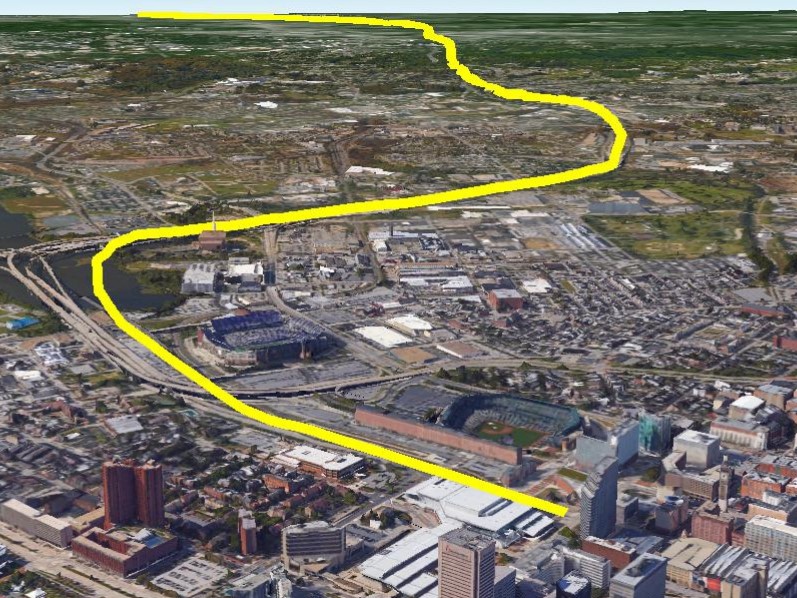
Six mile greenway loop for walking, running or cycling through historic West Baltimore from Carroll Park
 and its golf course in blue) around to the Gwynns Falls Valley (in green) and Downtown (in purple).

But while the new and old would be the complementary contrasting themes, a commitment to active recreation would be the overarching common theme.

The unifying element in West Baltimore would be a six-mile greenway loop. It would share much of the right-of-way of the proposed streetcar line in the B&O Railroad "First Mile" corridor, as well as the Red Line right-of-way in the "Highway to Nowhere" corridor, with many opportunities for transit oriented development.

This greenway loop would do for West Baltimore what the proposed waterfront promenade would do for Port Covington, each taking maximum advantage of its attributes - new waterfront development in Port Covington and two and a half centuries of history in West Baltimore.

In sum, Under Armour's Port Covington would be positioned not merely as the southern tip of the South Baltimore peninsula but as an anchor for the revitalization of West Baltimore. And golf at the Carroll Park course would be the attraction that leads the way.

February 10, 2016

MagLev for the Masses! ----- (5 basic rules)

Sorry - no spiffy futuristic pictures of MagLev trains in this article. Nobody knows what an American Magnetic Levitation system would look like yet. The whole point is that America offers a clean slate to reinvent high speed rail for the 21st century, without having to conform to expectations.

So the $28 million federal grant which the state recently received to study a MagLev line between Baltimore and Washington is very welcome. Throw away the preconceptions and open your mind. Don't make the same mistakes as China or Germany or the Maryland Transit Administration's 1990s study, and don't make new mistakes overreacting to the old ones.

Don't construe MagLev as a threat to Amtrak in the Northeast U.S. Corridor. No matter what happens, that line needs billions in improvements, and sooner rather than later.

But a fifteen minute ride at up to 300 mph from Baltimore to Washington, part of the world's most powerful urban corridor, would certainly be a "game changer" - that often abused term would certainly apply. So let's REALLY change the game.

A MagLev alignment in the I-95 corridor?

Five Basic Guidelines:


1 - Connecting to BWI-M Airport should not be a "given" - Airports are soooo 20th century! What's the point in getting to the airport in ten minutes so you can wait an hour in a security line? And how often do most people fly anyway? The purpose of MagLev should be to reinvent inter-urban travel, not to enable slightly quicker trips to Dubai, LA or Tokyo for which there's no competition anyway. In the 1990s study, this became a trap where the whole MagLev line became narrowly focused on affluent expense-accounted business travelers - an Amtrak Acela on steroids or a short-hop Concorde.

The airport area is devoted to supporting air travel, not overall urban activity like housing and jobs. Besides, linking to BWI-M would not be easy. There is no suitable right of way, and the cost and impact of tunneling is what killed the 1990s MagLev study, politically and otherwise.

2 - Don't assume maximum tunneling - After the 1990s MTA MagLev debacle, it's easy to just throw up our hands and say the whole thing needs to be all tunneled. Out of sight, out of mind. The 1990s study attempted to use an aerial alignment within the Interstate 95 corridor, but the deviations to serve the airport made it not worth the trouble, in cost, impact or in the extra travel time to slow down for the curves.

I-95 is straight and wide enough that an elevated line designed for sufficiently high speeds is possible, at a fraction of the cost of tunneling. And wouldn't it be cool to look out through your windshield and see MagLev trains whizzing by above you as you drive? Or look down from the MagLev above and see those old-school motorists like they're standing still? Both groups would then instantly know their place in the new travel paradigm.

It may not be as cool as the now-classic MagLev scene with Mount Fuji in the background, but BaltWash megalopolitans will identify with it.

3 - Plan for a whole new kind of "transit oriented development" -  For an intermediate station between the two cities, all previous rules and expectations should be thrown to the wind. What kind of community would grow up around the station for a 300 mph transit line that could whisk you to Baltimore or Washington in less than ten minutes, and ultimately to New York in well under an hour? Who knows??? The only thing we do know is that it would be unlike any community that has ever existed before, and that it would not look like a 20th century airport. And since it would be unique, it would be extremely valuable for living, working and visiting.

The station should probably be built on a simple platform over Interstate 95 with provisions for adjacent high density "air rights" development - possibly located next to the Konterra office park near Laurel or perhaps next to the UMBC research campus in Baltimore County, especially if access to BWI-M airport is still considered a priority. Or maybe both.

The station areas in Downtown Baltimore and Washington would also be profoundly affected, with the additional factor that unlike suburbia, our cities are the accumulations of all our past history and culture and continuing evolutions.

4 - Plan for convergent technologies that take advantage of MagLev's unique characteristics - The digital revolution is not just one invention with one technology. It has had profound spin-offs that affect everything from telecommunications to controlling "the internet of things". The two fundamental transportation differences involved with MagLev are: (1) The propulsion is in the guideway, not the vehicles, and (2) All systems must be automated to work in a coordinated manner.

These differences should cause secondary revolutions. All the old rules about driver reactions and vehicle spacings will be gone. Pre-determined schedules will be irrelevant and vehicles can be dispatched in real-time based solely on travel demand at any given moment. Trains would no longer have to be a certain length and size to achieve economies of scale, and could consist of smaller single driverless vehicles. Many of the ramifications of driverless automobiles currently being studied would apply more and sooner with MagLev. Stations and guideways could then be appropriately downsized as well, resulting in less cost and impact.

5 - Maximize expansion capacity! - This is the transportation revolution for the 21st century. All aspects of it should be optimized to allow maximum capacity expansion. All stations should have bypass tracks so that vehicles only need to stop as necessary, and vehicles can be readily brought on and off line as needed. The guideway should be designed as a "trunk line" with provisions for future branch lines to Columbia or Annapolis or wherever.

MagLev for the Masses!


In sum, MagLev should be planned and designed for the masses. Automobile and air travel were once the exclusive province for the rich, but inevitably they got to the mass market. Computers were once klunky things that cost many thousands of dollars. Now they're far more powerful and we put them in our pockets.

If anyone should have seen this, it was China with its billion-plus population, but they made the mistake of orienting their MagLev line to Shanghai Airport. What percentage of Chinese are air travellers? Not much.

Of course, it is America, not China, that's known for its freedom, innovation and personal upward mobility. Europe and Japan are known for their conventional high speed rail which has become part of their highly organized lifestyles. But America is now a blank slate for high speed transportation. That's why world investors and capital are becoming attracted to America for MagLev. Americans should be ready for anything.

February 3, 2016

Metro West speculation on the "Highway to Nowhere"

It's gratifying that the federal government was able to attract bids from reputable developers to buy its vacant former Social Security Administration Metro West complex at the west downtown end of the "Highway to Nowhere".

But it's obvious that the bids, which topped out at $7.1 million, are based purely on speculative value. With 1.1 million square feet of office space, that comes out to less than $6.50 per square foot. (Note: That's equivalent to $13,000 to buy a 2000 square foot  house - you could spend that much just for new floors.) And with about 12 acres over roughly 6 square blocks, there's enough land for much more development than that.

The top offer from Caves Valley Partners is based instead on their anticipation of how much concession of development incentives, tax breaks and infrastructure they might be able to cajole out of the public sector to make any redevelopment happen.

Seldom scene - The view from the westbound "Highway to Nowhere"  looking back eastward
 at the huge Metro West complex, which the eastbound highway splits in two.
This view is dominated by part of the site's vast open space which is landlocked in the middle of the highway. 

Also part of this speculation is how the city's real estate climate will be affected by all the developer deals the city has been making elsewhere, with Kevin Plank in Port Covington and Westport, plus Harbor East, Harbor Point, Canton Crossing, Old Town, State Center, La Cite in Poppleton, and the list goes on...

The city has been giving top dollar subsidies to the very best waterfront development sites, so that makes all the less desirable sites all that much less attractive and valuable. At Harbor Point, the city even gave big subsides to Exelon Corporation to locate there, when they already had to locate in the city by law. And this was after the city's politically powerful Downtown Partnership had already opposed the deal.

It's about as opaque and lumpy an economic "playing field" as one could imagine, with political acumen counting for much more than development acumen.

So it's not real value. Baltimore's real estate market is too dysfunctional for that. The recently concluded "auction" is actually the second attempt for the property, the first one ending with no winning bid.

This auction should also conclude with no winner. Instead, the city or state government should move in and acquire the land in accordance with federal procedures, so that the public sector can decide what investment is in the public's best interests, since the tax breaks and infrastructure will no doubt be financed with public money anyway.

At that point, a true developer solicitation can take place, based on real value, not speculative value.

But the public sector must decide what that real value can be. The nearby impoverished West Baltimore neighborhoods urgently need real help and a real connection to the economic energy of downtown. The issues are too large to leave it to a developer to set the agenda.

Inaction so far


The adjacent University of Maryland has rejected the site, instead proceeding with their ambitious building program elsewhere within their campus and neighborhoods.

The city and state have spent the past fifteen years analyzing the area with regard to the now-rejected $3 Billion Red Line light rail project. Their final plan failed to serve this site or the rest of the university campus. For various defunct reasons, the alignment and stations were located elsewhere.

Also, as part of that long process, the city steadfastly maintained that the "Highway to Nowhere" should stay. This highway splits the site, going right through a hole in the buildings. The city maintained this stance despite the fact that the state closed the highway for months to do prep work for the Red Line by demolishing a huge retaining wall at the west end of the highway, with minimal adverse impact on traffic patterns.

Metro West in the background from the vast landlocked wasteland inside the "Highway to Nowhere",
as seen from near where Fremont Avenue once was. 

The $3 Billion Red Line is now dead, so that a smaller and more viable Red Line plan can now be developed in its place, with more focus on supporting true transit-oriented development. As part of this plan, one or more stations can now be placed adjacent to or even inside the Metro West property.

The state's huge State Center government office redevelopment program, also over a decade old, is also in limbo. It may be seen that Metro West is a better location for some of this office space than State Center.

Planning questions to be answered


The Metro West site has terrific development potential, but it is far too hazy at this point. The property should be secured by the public sector, then the important planning decisions should be made:

Get rid of the "Highway to Nowhere"?

Build a viable downsized Red Line?

Develop a linear park in the Martin Luther King Boulevard corridor?

Create a traffic conflict-free development and greenway plan inside the Highway to Nowhere ditch?

Rehabilitate Upton, Lafayette Square and Harlem Park?

Expand the Heritage Crossing neighborhood?

Create an actually viable State Center plan?

Create an actually viable Lexington Market/Howard Street area plan?

More ideas?